


|
Getting your Trinity Audio player ready...
|
Colorado boasts an abundance of thrilling outdoor experiences, beckoning to those planning a road trip. Our comprehensive guide breaks down the state into 14 uniquely exhilarating regions, providing the perfect month-long itinerary for the ultimate adventure seeker.
Introduction
Ah, the centennial state. Home to over 3,000 stunning mountains, and the highest average elevation of any state in the Union, the “Roof of the US” has a ton to offer. From gnarly backcountry ski lines to intense mountaineering objectives, anyone with a heart that beats for the outdoors will find something to do here.
However, not all of us have free reign to pursue immersive outdoor activities. Given the stress of work and the limits of PTO, sometimes, a road trip is the best way to string together a series of fantastic destinations.
Because of how large Colorado is, I’ve divided the state up into bite-sized chunks that you can work through at your leisure. For those of you with remote schedules or an adventure van and a month of time, I’ve also included what I would consider a prime candidate for the ultimate Colorado road trip at the bottom.
Let’s get to it!

The iconic Twilight Peaks, a part of the massive San Juan mountains in southwest Colorado.
Table of Contents:
Article Navigation: Click on any of the listed items in the table of contents below to jump to that section of the article. Similarly, clicking on any large, white section header will jump you back to the Table of Contents.
- Introduction
- What’s In, What’s Out
- Seasonality
- Areas of Colorado
- 1 Front Range Foothills – Boulder
- 2 Rocky Mountain National Park
- 3 The Indian Peaks
- 4 James Peak Wilderness and Berthoud Pass
- 5 Far North
- 6 NW Corners
- 7 Pikes Peak
- 8 The I-70 Mountain Corridor
- 9 West-Central Colorado
- 10 The Aspen Pocket
- 11 The Crested Butte Pocket
- 12 Top of the Rockies
- 13 The San Juans
- 14 Dunes, Sangres, and Spanish Peaks Country
- One Crazy Colorado Itinerary
- Final Thoughts
What’s In, What’s Out
As with any list covering wide swathes of terrain, some areas will inevitably be excluded. Since this is a hiking, skiing, and mountaineering site, the expansive eastern plains of Colorado are largely ignored. That doesn’t mean there aren’t great things to explore there, though!
If you’re interested in what the plains can offer, research these great areas:
In addition to the eastern plains, a few mountain areas aren’t mentioned in much detail, including:
- La Plata Mountains
- The South San Juans
- The Raggeds
- La Garita Mountains
- Trinidad Area
- The Sangres south of La Veta Pass and west of the Highway of the Legends. A lot of private property here makes exploration tricky.
- Wet Mountains
- Buffalo Peaks Wilderness
- Castle Rock area and the Palmer Divide
- Rabbit Ears Range
- Fort Collins foothills. Stellar hikes like Horsetooth Rock, Lory State Park, and Greyrock are there for the taking.
- Red Feather Lakes

Longs Peak and Mt. Meeker in Rocky Mountain National Park.
Seasonality
The alpine is great and full of wondrous adventures, but Colorado seasons work a little differently than calendar seasons. Seasons here are super affected by seasonal snowpack, location, and elevation. Let’s compare:
- Calendar Winter: Dec. 21 – March 20
- Calendar Spring: March 20 – June 1
- Calendar Summer: June 1 – Sept. 22
- Calendar Autumn: Sept. 23 – Dec. 21
Colorado Seasons in the Front Range Urban Corridor (with large seasonal variations)
- Winter: mid-November to mid-April
- Spring: Late April to early-June
- Summer: June to late-September
- Autumn: October-mid November
Colorado Alpine Seasons: ( ~10,000-14,000 ft.)
- Snow: Mid-October-June/July
- Not snow: Late June/early July-September.
Again, these ranges can be affected by more intense snow years. For example, there was accumulating snow along the Front Range in mid-may 2019 for large portions of Denver, Boulder, and Fort Collins. When I worked as a trail builder in the San Juans, there was accumulating snowfall in August.
For a more in-depth analysis, please visit our article on where the snow falls in the great Centennial State.
In general, the higher and farther north and west you go, the more snow you’ll find. Ranges like the Flattops, Parks, San Juans, Elks, and West Elks can haul in snow from early autumn through late spring. The Front Range mountains near the cities tend to accumulate less (with the exception of the Far North areas like Cameron Pass). Ranges like the Sangres are very hit or miss; some years, they can be bone dry.

The snowy and appropriately named Never Summer Mountains near Cameron Pass.
Areas of Colorado
There are many mountainous areas in Colorado. Below, I’ve tried breaking them down into bite-sized chunks with useful information and at least a few adventures within them. Not all areas are covered (and certainly not all adventures, there are literally thousands!!), but if you mix and match the regions below, you’ll be able to create a stellar road trip worth repeating.
There are 14 total zones, which are numbered below. Use this map to reference their relative locations as you read on.
Please keep in mind that MANY areas in Colorado have poor or non-existent cell service. Plan accordingly.

1 Front Range Foothills – Boulder/Denver Region
The Front Range means different things to different people. It can be referred to as every range on and east of the Continental Divide, the Front Range Urban Corridor, or the first line of mountains encountered when traveling west from the Plains. For the purposes of this article, we’ll simplify the Front Range to the foothills and ranges west of the major urban corridors of the state.
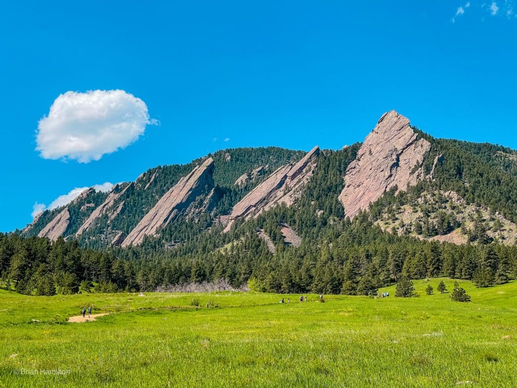
The Flatirons from Chautauqua Park in Boulder, Colorado.
- Adventure towns: Boulder, Denver, Golden
- Best hikes within an hour of Boulder, Colorado
- Great Boulder Hikes: Bear Peak, Walker Ranch Loop, Mt. Sanitas, Eldorado Canyon Trail, Green Mountain, and the Boulder 5-Peak Challenge
- Great Denver Hikes: Green Mountain, Mt. Morrison
- Great Golden Hikes: North Table Mt. and Golden Gate Canyon
Things to note:
- Trails here are VERY busy because they’re easy to access. Get to trailheads early and expect to pay parking fees at many of them.
- While beautiful (especially anything with views of the Flatirons), these trails won’t give off a secluded mountain atmosphere on weekends, be prepared to share the trail.
- Try adventuring at odd hours, like the later afternoons, weekdays, and as early as you can to help create a better experience.
Drive time from Denver
- 30 min to 1 hour
2 Rocky Mountain National Park
Rocky Mountain National Park (RMNP) is one of the crown jewels of northern Colorado. Spread over a quarter of a million acres, this hiker-centric park has over 400 named destinations to visit. Check out some of our favorite hikes below. Keep in mind that RMNP requires fees to enter.
Additionally, there are distinct east and western sides, with the eastern side being more immediately dramatic and closer to cities. It’s unsurprising then that this part of the park is by far the busiest. During the summer months, the two sides are connected by Trail Ridge Road, the highest continuous road in the US. However, during the long winter months, the road is closed, effectively splitting the park into separate regions.

The cliffs below Chiefs Head Peak from the Spearhead: Rocky Mountain National Park.
Or: source a picture
- Adventure Towns: Grand Lake, Estes Park
- Great Hikes: The Best Hiking Trails in RMNP
- Great Lakes: Best Lake Hikes in RMNP
- Backpacking: 5 Excellent Backpacking Routes in RMNP
- Waterfalls: Best Waterfall Hikes In RMNP
- Scrambles: Best Alpine Scrambles in RMNP
- Backcountry Skiing: Hidden Valley, Bear Lake Area, Mummy Ranges & Never Summers
- Scenic Drives: Trail Ridge Road, Bear Lake Road, Peak to Peak Highway
Drive time from Denver:
- 1 hour (Eastern side of the Park)
- 2-2.5 hours (Western side of the Park)
3 The Indian Peaks (IPW)
While much smaller than RMNP, the Indian Peaks is loaded with just as many adventures, which makes it worth a detailed exploration. The mountains here, like RMNP, are divided into an eastern and western portion. Unlike RMNP, there’s no road that connects them, so they are really two different sections unless you hike over the Continental Divide. The Eastern section is by far the most popular, with Brainard Lake Recreation Area and Hessie Trailhead likely the busiest access points.
Not only is this area dramatic and challenging, but there are also large glacial remnants here, similar to RMNP. Isabelle Glacier is the easiest to get to, but Fair Glacier, Navajo Snowfield, and Arapaho Glacier are obvious as well.

On the shores of Crater Lake in the western Indian Peaks Wilderness.
Or source own
- Adventure Towns: Nederland, Grand Lake, Granby
- Scrambles: Best IPW Scrambles
- Day Hikes: Isabelle Lake, snowshoe Niwot Mt., best hikes near Boulder, Mt. Irving Hale, Crater Lake, Gourd Lake,
- Backcountry Skiing: Brainard Lake Recreation Area, St. Vrain Area
- Ski Resorts: Eldora Ski Resort
- Scenic Drives: Peak-to-Peak Highway
- Overlanding Routes: Middle St. Vrain Trail
Drive time from Denver:
- 45 min – 1 hour (Eatsern Side)
- 1.5 – 2.5 hrs. (Western Side)
4 James Peaks and Berthould Pass
Just south of the Indian Peaks, the James Peak Wilderness and Berthoud Pass area are very popular because of their ease of access from both Boulder and Denver. There are miles of trails to explore, the popular St. Mary’s Glacier, backcountry skiing near Berthoud Pass, and resort skiing at Winter Park. The road up Berthoud Pass is paved, provides great access to the area, and when Trail Ridge is closed, is the closest alternative route to get to the western side of both Rocky Mountain National Park and the Indian Peaks Wilderness.

Rogers Peak Lake in the James Peak Wilderness, Colorado.
- Nearby Adventure Towns: Winter Park, Fraser, Idaho Springs, Blackhawk
- Great Hikes: Rogers Pass and Heart Lakes, Forest Lakes, Broome Hut, James Peak
- Off-roading: Rollins Pass (east side), Corona Pass (western side), Kingston Peak, Jones Pass
- Rafting: Clear Creek
- Scenic Drives: Peak-to-Peak Scenic Highway, Berthoud Pass
- Backcountry Skiing: St. Marys Glacier, Berthoud Pass
Drive time from Denver
- 45 min. – 1 hour (Eastern Side)
- 1 – 1.5 hours (Western Side)
5 Far North
The far northern mountains of Colorado are less tall and much less visited than other parts of the state. That doesn’t mean they aren’t stunning, though. One drive through Cameron Pass should drive that notion right out the window.
In this region, you have the northern and western Never Summer Mountains (a good chunk of the eastern side is in RMNP), the Medicine Bow Range (sometimes called the Rawahs to avoid confusion with Medicine Bow Peak in Wyoming), the remote Rabbit Ears Range, Park Range, and Elkhead Mountains. Between the major ranges is a massive high-elevation plateau called North Park.
Keep in mind that trails within Colorado State Forest State Park and Steamboat Lake State Park require an entrance fee.

The Medicine Bow Mountain Range from Parkview Mountain in the Rabbit Ears Range.
- Access towns: Steamboat Springs (Park Range and Elkhead Mountains), Walden (Rawahs, Cameron Pass, Rabbit Ears Range).
- Great Hikes: Lake Agnes, American Lakes, Ruby Jewel Lake, Hahns Peak, Gilpin Lake, Parkview Mountain, Fish Creek Falls
- Great Scrambles: Big Agnes
- Great Lakes: Steamboat Lake
- Rivers: Cache la Poudre
- Backcountry Skiing: Cameron Pass Backcountry Skiing
- Hot Springs: Strawberry Hot Springs
Drive time from Denver:
- Steamboat Springs (~3 hours)
- Cameron Pass (~2 hrs. 45 min.)
6 NW Corners
The northwest corner of Colorado has a distinctly desert feel, although sporadic steep ridges, canyons, and plateaus break up the monotony. This area, more than other, has a remote and “out there” feel to it, with few towns in the vicinity. The trade-off? Solitude, plenty of camping options, and some of the best star-gazing in the whole state.

Steamboat Rock at the confluence of the Green River and Yampa River in Dinosaur National Monument
- Access towns: Yampa, Meeker, Vernal (Utah), Craig
- Great hikes: Devils Causeway, Sand Creek Trail, Dinosaur National Monument
- Great lakes: Trappers Lake
- Rafting: Green River, Yampa River
- Scenic Drives: Flat Tops Trail
Drive time from Denver:
- Dinosaur National Monument: ~5 hrs.
- Yampa (Flattops): ~2 hrs. 45 min.
7 Pikes Peak
America’s mountain has been in the hearts and minds of many since being used as a Western landmark for wagon trains in the 1800s. This behemoth of a peak commands attention for a hundred miles and sticks out like a sore thumb. While it’s largely on its own, the uplift that created it also created a series of smaller peaks that support the varied topography of the area. Collectively, this bubble of mountains is known as the Pikes Peak massif.

Sunrise at the Garden of the Gods in Colorado Springs, Colorado.
- Access towns: Colorado Springs, Monument, Woodland Park
- Great hikes: Austin Bluffs, Crags Trail, Crags Campground to Pikes Peak, Barr Trail, Manitou Incline, Garden of the Gods, Cheyenne Mountain State Park
- Great Lakes: Crystal Creek Reservoir, Rampart Reservoir
- Off-roading: Mount Baldy Road, Rampart Range Road, Gold Camp Road, Eagle Rock
- Scenic Drives: Pikes Peak Road
Drive time from Denver:
- Colorado Springs: ~1 hr. 15 min.
- Woodland Park: ~1 hr. 35 min.
8 The I-70 Mountain Corridor
The highest highway in the continental US is also one of the main off-loading points for a lot of Denver’s metro area. And while the weekend traffic can be brutal, it’s such a central component of the road system in Colorado that it’s nearly impossible to avoid it. Thankfully, within a few miles of the highway are some of the easiest access mountains for those who want to get away but don’t want to stray too far from mountain towns and well-traveled areas.
Because I-70 is an east-west highway, there are three distinct sections of the mountain corridor. From east to west, they are Clear Creek County, Summit County, and Eagle County. Once you get through Glenwood Canyon, the physiology of the state changes enough to be called a separate area.
The ranges along I-70 are bulky, rugged, and beautiful. The corridor also contains a massive blob of some of the most popular ski resorts in the state. Additionally, there are a handful of 14,000 mountains to sink your teeth into. If you’re new to the state, chances are, one of your first hikes is going to be along the I-70 mountain corridor.

Tenmile mountain range with Lake Dillon
- Great Hikes: Grays and Torreys Peaks, Quandary Peak, Mohawk Lakes, Shrine Ridge, Herman Gulch, Mt. Royal, Willow Lakes, Piney Lake, Notch Mountain, Hanging Lake
- Great Lakes: Dillon Reservoir, Green Mountain Reservoir
- Great Scrambles: The Citadel and Hagar, 10-Mile Traverse (Peaks 1-5), Father-Dyer & Pacific Peak.
- Hot Springs: Glenwood Hot Springs, Iron Mountain Hot Springs, Indian Hot Springs
- Bike Paths: Frisco to Vail Pass, Glenwood Canyon Recreation Path
- Rafting: Glenwood Canyon, Clear Creek
- Ski Resorts: Loveland Ski Area, Echo Mountain, Arapahoe Basin, Keystone Ski Resort, Breckenridge Ski Resort, Copper Mountain, Vail Ski Resort, and Beaver Creek Ski Resort
- Backcountry Skiing: The Minturn Mile, Herman Gulch Backcountry Skiing Area, Vail Pass East
Drive time from Denver:
- Idaho Springs: ~40 min.
- Breckenridge: ~1 hr. 30 min.
- Frisco: ~1 hr. 20 min.
- Vail: ~1 hr. 40 min.
- Glenwood Springs ~2 hrs. 40 min.
9 West-Central Colorado
This broad area of Colorado covers a wide range of topographic and physiological landscapes. From desert lowlands around the Colorado River to Battlement Mesa, Grand Mesa, Roan Cliffs, and the Uncompahgre Plateau, there’s a lot to see! Generally seen as a thru-route to get to other mountainous regions like Crested Butte and the San Juans, this region is worth a closer look.
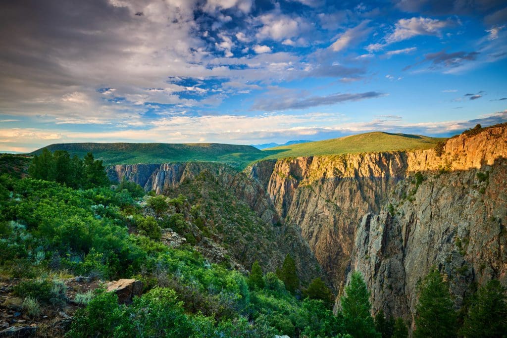
Black Canyon of the Gunnison.
- Access Towns: Grand Junction, Fruita, Montrose, Delta, Rifle, Glenwood Springs
- Great Hikes: Crag Crest Trail, Cedar Point Trail, Roan Cliffs Chaos, Rifle Arch Trail, Black Canyon of the Gunnison NP
- Wine Trail: Grand Junction Area Wineries
- Mountain Biking: Fruita area trails
- Rivers: Rafting/tubing adventures near Grand Junction
- Great multi-use area (off-roading, hiking, rivers, camping): Dominguez-Escalante NCA
- Scenic Drives: Unaweep-Tabeguache
- Resort Skiing: Powderhorn
Drive time from Denver:
- Glenwood Springs: ~2 hrs. 40 min.
- Grand Junction: ~4 hrs.
- Fruita: ~ 4 hrs.
- Montrose: ~5 hrs.
10 The Aspen Pocket
Everyone and their mother has heard of Aspen. This sleepy mountain town is also one of the richest areas in the Rocky Mountains (similar to Jackson Hole). Despite its unaffordable reputation (move over millionaires), it’s the terrain around it that makes it a 4-season playground. Bookended by the western Sawatch Range and the rugged Elk Mountains, the Aspen pocket is a spectacular place to launch countless outdoor adventures from.

The rugged Capitol Peak from near the trailhead to Capitol Lake.
- Access Towns: Aspen, Basalt, Carbondale, Glenwood Springs
- Great hikes: Crater Lake/Maroon Bells, Capitol Lake, Mt. Sopris, The Ute Trail, Sunnyside Trail
- Backpacking: 4 Pass Loop
- Hot Springs: Conundrum Hot Springs, Glenwood Springs, Iron Mountain Hot Springs
- Resort Skiing: Aspen Mountain, Aspen Highlands, Buttermilk, Snowmass, Sunlight Mountain Resort
- Water holes: Devil’s Punchbowl
- Scenic Drives: Independence Pass Road, McClure Pass (part of the West Elk Scenic Byway)
- Off-roading: Cottonwood Pass (not the one near Buena Vista)
Drive time from Denver:
- Aspen: ~3 hrs. 30 min.
- Carbondale: ~3 hrs.
11 The Crested Butte Pocket
Similar to the Aspen Pocket, Crested Butte sits near the head of a valley. The main way in and out is through Gunnison, which gives Crested Butte a lost-world type of atmosphere. The mountains here are big and lumpy and accessed through a network of old logging roads or snowmobile trails in the winter.
A high mountain pass through the Elk Mountains separates the Crested Butte Pocket from the Aspen Pocket, although the distance isn’t very far. It is possible to hike between them.

Crested Butte, Colorado.
- Access Towns: Montrose, Gunnison, Crested Butte
- Great Hikes: Cinnamon Mountain, Frigid Air Pass, Rustlers Gulch, Storm Pass
- Great Lakes: Taylor Park Reservoir, Blue Mesa Reservoir
- Off-roading: Crystal Mill, Tin Cup Pass
- Scenic Drives: West Elk Loop
Drive time from Denver:
- Crested Butte: ~4 hrs. 15 min.
- Gunnison: ~3 hrs. 45 min.
- Montrose: ~5 hrs.
12 Top of the Rockies
This section’s named after one of the scenic roads that bisect the area and for its access to the biggest (and largest) concentration of 14,000-foot mountains in the state. The bulk of the section centers on the Upper Arkansas River Valley, with adventures present in both the Sawatch Range and the Tenmile/Mosquito Range, including the Buffalo Peaks Wilderness.

Hikers at 12,000 feet on Colorado’s Lost Man Trail near Independence Pass.
- Adventure Towns: Leadville, Salida/BV (Buena Vista)
- Great Hikes: Interlaken, Mt. Elbert, Mt. Massive, La Plata Peak, Mt. Yale, Mt. Harvard, Mt. Princeton, Huron Peak
- Great Lakes: Turquoise Lake, Twin Lakes, Clear Creek Reservoir
- Hot Springs: Mt. Princeton Hot Springs
- Off-roading: Hagerman Pass Road, Weston Pass, Red Cone (farther away and on its own)
- Rafting: Arkansas River (multiple sections)
- Ski Resorts: Ski Cooper, Monarch Mountain
- Backcountry Skiing: The 10th mountain Huts near Tennessee Pass (The Sangree M. Froelicher Hut, The Emmelyn Hut, Vance’s Cabin, Continental Divide Cabin, Point Breeze Cabin, 10th Mountain Division Hut, Uncle Bud’s Hut, Skinner Hut)
- Scenic Drives: Top of the Rockies, Cottonwood Pass, Monarch Pass
Drive time from Denver:
- Leadville: ~ 1hr. 45 min.
- BV: ~ 2 hrs. 15 min.
- Salida: ~2 hrs. 35 min.
13 The San Juans
This region is not only the most mountainous in the state, but it’s also home to some of the most stunning scenery. Created from long-forgotten volcanic activity, the San Juans are a perfect hiking destination with jaw-dropping views and a smattering of hot springs as well.
While it’s easy to find a hike near well-traveled roads, the largest wilderness in the state, the Weminuche access half a million acres of roadless terrain. The opportunity for a massive and remote backpacking trip exists.

Little Molas Lake, San Juan Mountains, Colorado.
- Aventure Towns: Ouray, Telluride, Durango, Pagosa Springs, Lake City, Montrose
- Great Hikes: Courthouse Mountain, Columbine Lake, Ice Lake, Mt. Sneffels, Cliff Dwellings at Mesa Verde National Park, Chicago Basin
- Great Lakes: Lake Nighthorse, Vallecito Reservoir, Vallecito Lake, Rio Grande Reservoir
- Hot Springs: Pagosa Springs, Dunton, Ouray Hot Springs, Rainbow Hot Springs, Piedra River Hot Springs, Orvis Hot Springs
- Off-roading: Imogene Pass, Cinnamon Pass, Pagosa Peak Road, Alpine Loop, Ophir Pass
- Rafting: Animas River, Dolores River, Uncompahgre River
- Ski Resorts: Purgatory Ski Resort, Telluride Ski Resort, Silverton Mountain, Wolf Creek Ski Area
- Scenic Drives: San Juan Skyway, Wolf Creek Pass, Slumgullion Pass
Drive time from Denver:
- Ouray: ~5 hrs. 30 min.
- Telluride: ~6 hrs. 10 min.
- Durango: ~ 6 hrs. 5 min.
- Pagosa Springs: ~5 hrs.
- Lake City: ~4 hrs. 45 min.
14 Dunes, Sangres, and Spanish Peaks Country
This sprawling area is both unique and historically relevant. The Great Sand Dunes are the most popular area and are absolutely spectacular. Behind them, the rugged and intimidating Sangre De Cristo Mountains reign supreme over south-central Colorado. Farther east, the Spanish Peaks sport a wonderfully unique environment, complete with radial magma dikes that harken back to Colorado’s volcanic history. Punctuated by hot springs, and funky towns, this is a cool and underutilized part of the state.

Sunset view of sand waves at the top of Great Sand Dunes, Great Sand Dunes National Park & Preserve, Colorado.
- Access Towns: Alamosa, Walsenberg, Westcliffe, Pueblo, Cañon City, Crestone
- Great Hikes: Willow Lake, Kit Carson Peak, South Colony Lakes, Blanca Peak, Star Dune (Great Sanddunes National Park), West Spanish Peak, Cordova Pass
- Great Lakes: Lake Pueblo (State Park)
- Unique things to do: Sandboard at Sand Dunes NP, visit Bishops Castle, visit Royal Gorge Bridge
- Hot Springs: Valley View Hot Springs, Splashland
- Off-roading: South Colony Lakes Road, Lake Como Road (commonly cited as one of the toughest roads in the state)
- Scenic Drives: Highway of Legends
Drive time from Denver:
- Alamosa: ~3 hrs. 50 min.
- Westcliffe: ~2 hrs. 50 min.
- Cañon City: ~2 hrs. 10 min.
- Pueblo: ~2 hrs.
One Crazy Colorado Itinerary
What if you had a month and wanted to hit all of those places? Well, you’re in luck!
Below is an itinerary that crisscrosses the state in a way that hits a ton of pretty destinations and tries to avoid bottlenecks like I-70 and some Front Range areas. It won’t cover everything, but it will give you a better understanding of how many cool places exist in Colorado.
It’s a perfect itinerary for an adventure van and remote workers or those that have built up some wild PTO. In either case, you’ll get so much Colorado you won’t know what to do with it. Let’s take a look!
Please keep in mind that this itinerary assumes minimal snow on the ground, so it’s best appreciated from July-mid September.
First, start in the Front Range, ideally in Denver, Boulder, Fort Collins, or Colorado Springs.

Colorful Sunset at Sloan’s Lake in Denver, Colorado
Day 1: Make your way to Brainard Lake Recreation Area, where a plethora of hikes in the IPW await with paved access. If you can’t score a reservation permit, alter the plan to hit up Hessie, 4th of July Trailheads, or the East Portal, which are free to access but are super popular. Don’t show up on a weekend and expect to park even close to the trailhead. There is a shuttle that runs from Eldora highschool to Hessie. End the day in Estes Park.
Day 2: Get those RMNP passes early and head to the Bear Lake Trailhead, where the iconic Emerald Lake, Dream Lake, and Odessa Lake await. Then, take a leisurely drive up Trail Ridge Road, which crosses the park and offers stellar mountain views, along with plenty of pull-offs to get out and stretch your legs at. End the day in Grand Lake.
Day 3-4: Visit the iconic Grand Lake Lodge, and grab a pontoon boat on either Grand Lake, Shadow Mountain Lake, or Lake Granby. A ton of great camping exist close by, so this is a perfect place to camp out for a day or two.
When you’ve had your fill, drive south on US 40 to a three-way intersection outside of Granby. Follow signs for 40 West (take a right) and head to Kremmling, eventually crossing over the Continental Divide at Rabbit Ears Pass. Make your way to Steamboat Springs and enjoy the town, along with a dip in Strawberry Hot Springs. Be aware that the hot springs are clothing optional after dark.

Rabbit Ears Pass near Highway 40, Colorado.
Day 5: Spend a day exploring the Mt. Zirkel Wilderness north of Steamboat and head to the beautiful Gilpin Lake. If you want a shorter but just as dramatic excursion, try Hahns Peak. Return to Steamboat and relax.
Day 6-7: Head north and west to the remote and beautiful Dinosaur National Monument, where you could spend anywhere from a few hours to a few days.
Day 7-8: Pick up the Flattops Trail scenic highway and cross this lightly populated but gorgeous part of the state. Trappers Lake is particularly impressive. End the adventure in Grand Junction.
Day 9: Explore this laid-back area by checking out some nearby wineries and the biking mecca of Fruita, or perhaps take a scenic drive up the Grand Mesa to the Land’s End Observatory. Spend another night in the Grand Junction area.
Day 10: From here, drive toward the West Elks, passing a few wineries en route, and drive over McClure Pass. On the other side, grab a beer in the funky mountain town of Carbondale before heading through Aspen. You can stay in the area, but places like the Maroon Bells are exceptionally popular, so make sure to plan ahead, whether it’s camping or an Airbnb.

Majestic Maroon Bells peaks and Maroon Lake near Aspen, Colorado.
Alternatively, you can blow through Aspen and head up Independence Pass. There are secret swimming holes and scenes galore as you head into the Sawatch mountains. Get out and stretch your legs on top of the pass before descending down to Twin Lakes. There are numerous camping spots here to enjoy. If you want to spend a night indoors, head to Leadville.
Day 11: Spend the morning checking out Leadville and its storied wild-west history, all in the shadow of Mount Massive. You can hike Mt. Elbert, the tallest in Colorado, from a base camp near Leadville. Turquoise Lake has many campsites.
Day 12: This day is all about the Arkansas River. You’ll drive alongside it as you cruise down to Buena Vista. Get a rafting tour down Browns Canyon, or stop into Eddyline Brewing for a fresh beer. If you have the time, check out Mt. Princeton Hot Springs. Spend the night in Salida.
Day 13: Enjoy the morning in Salida before heading up to Monarch Pass, where more views await. One of the best mountain biking routes in the state, the Monarch Crest Trail, is here, which could convince you to hang around the area a bit longer. In either case, you’re next destination is Gunnison.
Day 14-15: You can stay in Gunnison or Crested Butte, but you should head up to the ‘butte’ and check out the stunning scenery. Stay and recreate in the Gunnison or Crested Butte area.

Crested Butte, Colorado town cityscape high angle view from Snodgrass hiking trail in summer with alpine meadows and aspent trees forest grove
Day 15: From Crested Butte or Gunnison, head to Ridgway. From there, head west for stunning views of the Dallas Divide and the imposing Mt. Sneffels. Continue on to the picturesque town of Telluride. Telluride is in a box canyon and boasts some of the best town views in the state.
Day 16: Today’s a mountain-to-desert day. Head south and west to Mesa Verde National Park, where Native American ruins and cliff dwellings await. Camp near or in the National Park. Other local towns like Mancas have decent camping nearby.
Day 17-18: Continue to Durango and enjoy the laid-back atmosphere along the Animas River. Breweries, restaurants, and trails abound. There are also a few great horseback riding options on some of the ranches around town. When you’re satisfied, continue east to Pagosa Springs and find camping or a hotel to stay in. The Springs has, unsurprisingly, hot springs! Take a soak and let stress slide away.
Day 18-19: Backtrack briefly to Durango before heading north on US 550. This stretch goes right through the heart of the San Juans and is probably the pretties stretch of road in the state. You’ll cross Coal Bank Pass, Molas Pass, and Red Mountain Pass, all of which have hiking options. My pick, however, would be to take a hike to Ice Lakes or Columbine Lake. Spend the night in or near the iconic town of Ouray.

Mt. Sneffels and the Dallas Divide in the San Juan Mountains, Colorado.
Day 20: From Ouray, you can access Yankee Boy Basin and take a shot at scrambling up Mt. Sneffels. If that doesn’t sound fun, head north to Black Canyon of the Gunnison National Park. Not only is the canyon deep and dramatic, but the whole area is also a dark sky park and, like Dinosaur National Monument, will have amazing star gazing opportunities.
Day 21: Back south! From the canyon, take the road to Lake City (US 50 east and then south on CO 149). While “city” is a stretch, this town is perfectly situated to grant access to gorgeous mountain terrain. If you want to climb a big mountain with less effort, try Handies or Redcloud. If you want a taste of scrambling, string together a combination of Uncompahgre and Wetterhorn. Spend the night camping in the area.
Day 22: Head south over Slumgullion Pass and enter one of the more remote stretches of the state. There are lakes and hikes a plenty. For hardier folks, I’d recommend Rio Grande Pyramid because it’s on its own with plenty of prominence and killer long-range views. However, it is an 18-mile hike, so come prepared. If you don’t want a hike, continue to Del Norte, or, if you’re dedicated, cut across the San Luis Valley and book it to the Great Sand Dunes National Park.
Day 23: Camp and spend at least a day here. Splash around in Medano Creek, climb the highest dunes, or give sandboarding a try! This is also a reservation area for camping, make sure to jump on campsite options fast, or settle for lodging at nearby trailheads or the town of Alamosa. The elusive clothing-optional Valley View hot springs are north of the park, along with the always interesting hippy town of Crestone.
Day 24: Head south and east over La Veta Pass to enter Spanish Peaks Country. Be aware, a fire has impacted the immediate area around the pass. This is a great and often ignored area of the state. The Spanish Peaks, like Pikes Peak, were used as markers for wagon trains heading west in the 1800s. They are large, lumpy peaks with a large amount of prominence. Highway of the Legends, a Colorado Scenic Byway, is the best way to circle around and enjoy the area. Don’t forget to check out the magma dikes that ring the area and provide wonderful backdrops.
Spend the night near Westcliffe.

The Great Dikes rock formations in the Spanish Peaks of Colorado.
Day 25: Continue driving north until you hit US 50, then take it east to Cañon City. Check out the touristy but still very impressive Royal Gorge Bridge, which spans a dramatic canyon that the Arkansas River cuts through. There are also many trails along the canyon walls. From here, head briefly west on US 50 and then north on US 9 into the high plateaus of South Park.
You have some options here. The quick and dirty version is to bust up through Fairplay, Alma, and over Hoosier Pass to get into Breckenridge where you can spend a couple of nights. Or, head to the Lost Creek Wilderness and camp. If you opt for the latter, check out Bison Peak, this 9-mile hike leads to a prominent summit dotted with enormous boulders. It’s unlike any summit in the state.
Head to Breckenridge via 285 and 9 afterward.

Lower Mohawk Lake Breckenridge, Colorado.
Day 26-28: Summit County is a mountain playground, and you’ll have no trouble finding activities here. Breck is a funky town with hostels, hotels, and Airbnbs. Classic area hikes include Mohawk Lakes, Quandary Peak, the ten-mile range around Frisco, and Willow Lakes in the Gore Range. Lake Dillon is also here, offering another chance to get out onto the water on a pontoon.
Whenever you’ve had your fill (or you run out of money), take I-70 from summit county east over the Continental Divide. The road will dip east toward Denver. If you have any time left over, stop in Idaho Springs for great pizza at Beaujeaus, or pop into Golden, whose revived downtown and Coors factory always draw interest.
Once you’re back in Denver, make your way home or back to the airport.
Final Thoughts
Colorado is a massive state. There are so many hikes and adventures that you won’t be able to do them all in one lifetime. However, breaking up the state into manageable chunks and stringing together some epic roadtrips can give you an intimate look at the most beautiful locations in the state. Have fun out there!

