


|
Getting your Trinity Audio player ready...
|
The beloved Hidden Valley Ski Area in Rocky Mountain National Park boasted a steep 2,000-foot vertical drop and was popular for its proximity to residents. Nevertheless, these pathways still provide easy access to the wilderness for contemporary backcountry skiers, Sledders and snowshoers.
As time moves forward, fewer and fewer people remember the ski resort in Rocky Mountain National Park. The Hidden Valley Ski Area was a beloved spot for locals, offering a quick drive of only 45 minutes to get there, much less than the lengthy trek required to reach the ski resorts of U.S. Interstate 70. Unfortunately, the area closed in 1991 after 36 years of operation.
Hidden Valley ski area boasted a steep 2,000-foot vertical drop from 11,400 to 9,400 feet, which made it an ideal spot for skiers of all levels—30 percent beginner, 30 percent intermediate, and 30 percent expert. On top of that, there was a base lodge with cafeteria and gift shop, ski patrol headquarters, and a large parking lot. In 1971, the area added a double chairlift, and the area became known as the go-to spot for Northern Colorado residents to ski without having to travel along Interstate 70 to the larger resorts. In 1984, a season pass was $100 while a daily lift ticket for an adult cost $10.
With less-than-ideal snowfall on the ski runs, an adjustment of the park’s focus to prioritize recreational activities other than skiing, and wider management issues preventing Hidden Valley from competing with more popular Colorado resorts, the fate of the area was sealed.
Warning: For ANYONE traveling into avalanche territory, consider enrolling in an Avalanche training course by AIARE; it absolutely save lives.
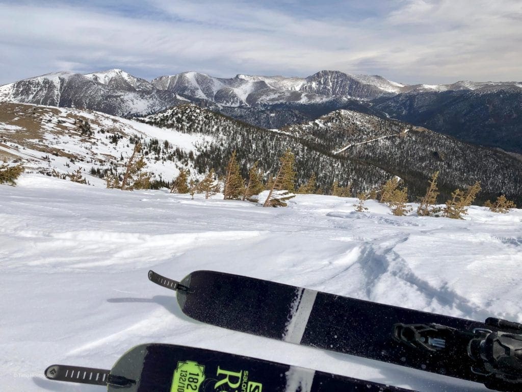
Photo of the Mummy Range from Hidden Valley. Photo by Timo Holmquist.
Nestled between Lower and Upper Hidden Valley, along Trail Ridge Road, the resort boasted a lodge, ski school, and a parking lot that fit 500 cars. It also had ski lifts and rope tows, as well as a small ice-skating pond close to the parking lot.
When the resort closed, all of its grandeur was stripped away, leaving behind only a parking lot and a hut that had been constructed using some of the old lodge’s materials. The ski runs, however, still slice through the lush subalpine forest that surrounded Hidden Valley.
Despite being around for more than three decades since the ski resort shut down, many of the trails are finally starting to be filled with native vegetation once again. Nevertheless, these pathways still provide easy access to the wilderness for contemporary backcountry skiers and snowshoers.
It’s just 1.1 miles from the shelter at the west end of the lot to Trail Ridge Road’s high point, and snow-lovers may be tempted to take on this trail for a quick winter adventure. However, be aware that in this short distance, this path rises over 1,066 feet with some sections as steep as 40%.
Hidden Valley brings the goods from March-May. It is possible to ski before then, but avalanche danger is noticeably higher. It is always advisable to wait for snowpack consolidation. Hidden Valley doesn’t usually slide, but it has in the past, so as always, never go into the backcountry without checking the weather and avalanche conditions.
If you’re ready to tackle the steep ascent up Hidden Valley, begin your journey in the parking lot 7 miles west of the Beaver Meadows Entrance on Trail Ridge Road.
Make your way to the western side of the warming hut and then go straight up through the valley. The path increases in elevation from its beginning elevation of 9,412 feet, and passes by a picnic area to the left. You can also spot some abandoned ski trails. Further ahead lies the snow play area, which is the only part of the park where you’re allowed to use plastic sleds.
Climb through the snow, following pre-existing footprints, as the path is not marked. Use our nearby interactive 3d map to help you find your way around. OnX Backcountry, the GPS navigation app, is very useful, especially if the wind whips up and covers up the trail with new snow.
Around half a mile ahead, the path gets steep and goes up from 10% to 45% in the next half mile. Despite the aching in your calves, you have only 0.1 mile to cover until you reach Trail Ridge Road, which stands at 10,498 feet. So, it’s best if you press on.
For a gear guide and introduction to all essential backcountry skiing items, please visit our Backcountry Ski Gear Article.
Hiking up the steep slope can seem like a never-ending slog, but take the time to pause and appreciate the scenery. If you look out eastward, you’ll be presented with a view of thick lodgepole trees. Patches of tundra peek through between the branches. The sounds of Hidden Valley Creek can be heard along the route, bubbling beneath a canopy of snow. You might even catch sight of some wildlife, like pine squirrels, mountain chickadees and snowshoe hares, skittering around in the trees.
To rejoin the trailhead, trace your steps back out of the valley. Maneuver cautiously on the more treacherous parts of the descent to avoid any runaway sliding down steep parts. Backcountry skiing is a common activity here, so watch for other trail users and make sure to steer clear of them, particularly in denser woodlands.
If you’re interested in other winter pursuits available at Rocky Mountain National Park, including sledding, skiing, and snowshoeing at Hidden Valley, visit nps.gov.
Sledding and Tubing
In the winter, this area has become a hotspot for various adventures. Topping the list of activities is still sledding down the slopes. It has become known as one of America’s best sledding hills. On snowy days, the hill is full of families trudging to the peak of the wide path with their sleds or tubes in tow, ready to make the swift descent. Some even link their tubes together, creating a group journey down the hill. (Sled rentals are available for $5 daily from Estes Park Mountain Shop.)
The Ultimate Offline GPS Hiking & Ski Maps
See why onX Backcountry is the ultimate GPS navigation app for your outdoor pursuits. Try Today for Free. No credit card required.

Backcountry Skiing
The ski slopes from decades ago, though narrower than today’s standards, are open for backcountry skiing and snowboarding. Those who are willing to make the journey can find plenty of powder stashes on the higher slopes with low angles. Before anyone starts their journey, they must come prepared with avalanche gear, like beacons and transceivers, as well as know how to use them. Since the old army truck that used to take people to Trail Ridge Road is no longer around, backcountry skiers and riders have to make the trek up on their own using skins or snowshoes. Though it may be an uphill battle, the panoramic views become more breathtaking the higher you climb.
For those looking to tip-toe into the area backcountry scene, Hidden Valley and Sundance Mountain are perfect places to run some laps, build skill and enjoy the possibilities of backcountry. Here’s our Hidden Valley and Sundance Mountain map with the ascent line shown in yellow and the backcountry lines shown in blue:
3D Map Navigation Instructions
On desktop: Hold the ctrl key while you drag to rotate the map. Use your mouse scroll to zoom in and out.
On mobile: Rotate and zoom on mobile by pinching and moving two fingers.
We recently published a series of four articles dedicated to skiing the more famous backcountry ski lines in Rocky Mountain National Park, Colorado. Skiers will be interested in our four part series dedicated to skiing the more famous backcountry lines in Rocky Mountain National Park including Hidden Valley and Sundance Mountain Area, Bear Lake Area, Longs Peak Area and the best of the remaining ski lines in the Mummy Range and the Never Summer Mountains.
Getting to Hidden Valley
Hidden valley is best accessed from the east. Enter the National Park on either US 34 or US 36 and drive west. Both roads pass some flat, high elevation grasslands before entering a pine forest. A little less than 2.8 miles from the intersection where US 34 and US 36 link-up, a sharp hairpin turn to the left marks the entrance to Hidden Valley. Signs are plentiful, though they can be obscured in blowing snow or blizzard conditions. Take a right onto the Hidden Valley access road and follow it for 0.4 miles until arriving at the parking area.
Remember, an entrance pass is required to visit Rocky Mountain National Park. These passes can be purchased online. Please visit the official National Park website to ascertain what passes and entrance fees are required. Fines will be administered to those without proper passes.
Even though Hidden Valley is open in the winter, during and right after heavy snowstorms, access may be temporarily closed until roads can be safely plowed. Plan accordingly.
Check out our Guide to Planning a Backcountry Ski Adventure for an in-depth analysis of the planning process. A good plan can separate success from disaster. No outdoor activity is worth your life.
Global Rescue is there whether you’re hiking, kayaking, snowmobiling, fishing or simply enjoying the outdoors and get ill or injured and you’re unable to get to safety on your own. Global Rescue is the red button you push in an emergency. Their team of medical and security experts come through for you when it matters most.
Global Rescue has also expanded services to include local field rescue within 100 miles of home.
Popular Articles:
Guide to Backcountry Skiing in Rocky Mountain National Park’s Hidden Valley and Sundance Mountain
Trek The Hidden Trails of the Icelandic Highlands In 2023
Adventure Talk: Discover the Hidden Trails of Iceland
Guide To Planning A Backcountry Ski Adventure
Support Skyblue Overland™ on Patreon!
If you’d like to support our efforts for a few dollars a month, please subscribe to our Patreon page. Every donation energizes our team to keep writing detailed trail reviews, gear reviews and adventure guides. Thank you!


