


|
Getting your Trinity Audio player ready...
|
The Indian Peaks Wilderness (IPW) in Colorado rivals Rocky Mountain National Park’s beauty, but only takes up a fraction of the space. 13,000 foot peaks, wildflowers, alpine lakes, and winter backcountry runs make it stunningly beautiful. Its rewards are plentiful, much like its national park neighbor to the north. This article details the most popular backcountry lines in the IPW.
Introduction
Tucked along the Continental Divide in northern Colorado is a wilderness that rivals the beauty of Rocky Mountain National Park at only a fraction of its size. The Indian Peaks Wilderness (or IPW) has long been a famous adventure destination for Front Range enthusiasts due to its prime location and stunning natural beauty. The wilderness is over 76,000 acres in size, straddling an uninterrupted section of the Continental Divide only an hour from the north Denver metro area. Peaks in the wilderness routinely pierce 13,000 feet, and the area is ripe with wildflowers and alpine lakes. During the winter months, the Indian Peaks host some of the most popular and epic backcountry runs in the northern half of the state. Like its national park neighbor to the north, the variety is astounding and the rewards plentiful.
Despite its smaller size, the incredible amount of adventure necessitates multiple focus points. This is the first of four articles attempting to detail the most popular backcountry lines in the IPW. The wilderness is interesting because it is sandwiched between Rocky Mountain National Park to the north and James Peak Wilderness to the south, with no roads bisecting the area from east to west. This unique position means the wilderness can be divided into two large components, the ultra-popular eastern side of the divide and the quieter, but no less dramatic, western portion. The first three articles in the series will break down the eastern side of the IPW and analyze the backcountry lines there, while the fourth article will attempt to organize the opportunities on the western side. This particular article will zero in on St. Vrain Mountain, arguably the best introduction to the IPW, and the more isolated Middle St. Vrain Drainage, which hosts some incredible backcountry lines and multiple glacial remnants.
Backcountry Skiing comes chock full of benefits and risks, almost in equal measure. It is a discipline that rewards methodical and purposeful learning with a deeper connection to nature. It can also be very dangerous for the uninitiated and seasoned veterans alike; avalanches don’t pick favorites. However, by arming yourself with the right gear and planning knowledge, backcountry skiing can satisfy the outdoor itch for multiple lifetimes.
Quick Navigation
Article Navigation: Click on any of the listed items in the table of contents below to jump to that section of the article. Similarly, clicking on any large, white section header will jump you back to the Table of Contents.
- Backcountry Gear
- Backcountry Planning
- Indian Peaks Wilderness Overview
- Indian Peaks Weather
- Access
- Places to Stay
- Our Ratings
- St. Vrain and Meadow Mountain
- East Ridge (St. Vrain)
- South Slopes (St. Vrain)
- North Face (St. Vrain)
- Meadow Mountain/Meadow Mountain Trees
- Middle St. Vrain Drainage
- Red Deer Mountain: East Slopes
- Red Deer Mountain: Red Deer Couloir
- Red Deer Mountain: Southeast Face
- Sawtooth Mountain: Northeast Face
- Sawtooth Mountain: Southeast Chute
(Please Note: Some of the parent lines listed above have add-ons and variations, which are also discussed)
Backcountry Gear
Before we begin, let’s lay out some quick backcountry gear knowledge (for a more comprehensive guide, check out our article, Backcountry Gear: Essentials for Human Powered Skiing). The list below is crucial, don’t skimp on gear when avalanches are in play.
- Skis/Helmet/Gloves/Goggles
- Winter Clothing: waterproof shells, thick ski socks, layers, puffy, beanie, hand warmers, etc.
- Skins
- AT Bindings (Frame or Tech)
- Avalanche Gear: Beacon, Shovel, Probe, and Radio
- Backcountry ski pack
- Food/Water/First-Aid Kit
- For multi-day adventures: 4-season tent, winter rated sleeping bag, avalanche airbag, orienteering equipment, batteries/rechargeable batteries
- Mountaineering Axe and Crampons. While there are hundreds of lines that do not require these tools, some of the most epic lines in the Indian Peaks Wilderness do. Research which crampons fit over your alpine or tech boots before buying! Generally speaking, you do not need an “Ice” axe unless you are climbing an ice wall; a mountaineering axe should work fine for most couloirs. However, some of the hardest ski mountaineering routes in the area demand more. Analyze your skill level and the route of choice BEFORE settling on gear options.
Remember, it isn’t enough to simply own gear; take the time to figure out how to use it before heading out. Speed is key, especially in a backcountry avalanche rescue. Visit Backcountry Gear: Essential for Human Powered Skiing to get comfortable with the necessary gear and how to use it.
Backcountry Planning
Once you have the gear and know how to use it, it’s time to start planning. We’ll briefly break down the central components below, but check out our Guide to Planning a Backcountry Ski Adventure for an in-depth analysis of the planning process. A good plan can separate success from disaster. No outdoor activity is worth your life.
- 1) Pre-Planning
-
-
- Learn how to Ski at an EXPERT level before heading outside ski resort boundaries. Find a squad. Start backcountry gear research. Hone your craft. Get in shape.
-
- 2) Long-Term Planning
-
- Geographic reduction: where are you skiing? Start big, get small.
- Weather and snowpack research.
- Research ski lines using books, online resources, and forums. Key data:
- Total distance, total climb, total descent, slope angle
- Local Emergency contacts
- Unique factors: trees, cornices, couloirs, avalanche history
- Get into the maps and apps, know the area like the back of your hand.
- 3) Short-Term Planning
- Managing Expectations
- Constantly check weather updates until the morning you leave. Remember, snow reflects light, if it’s a sunny day, bring sunscreen!
- Popularity of your backcountry line.
- Tell people where you’re going and who to call if things go wrong.
- Have a back-up plan.
- Who’s got the medical training?
- Go over the plan in detail with your squad. CHECK FOR UNDERSTANDING.
- Packing
- Make sure everything fits, and you can access your avalanche gear quickly. Time is critical in a burial situation.
- Managing Expectations
- 4) On-site Planning
- What do you see when you get there?
- Watch out for tree-wells, wind-loaded slopes, cornices, bergschrunds, and other topographical considerations.
- Timing and snow surface i.e. environmental factors. Not all snow skis the same.
- What do you see when you get there?
- 5) Post-Planning
- Analyze
- What worked well? What didn’t?
- Ease into the harder stuff.
- Analyze
The steps listed above are only a skeleton outline; see our Guide to Planning a Backcountry Ski Adventure to iron out the critical details. Remember, you can always take an avalanche safety course through AIARE; it can absolutely save lives.
IPW Overview
The IPW is one of the most popular wilderness areas in Colorado, and for good reason. Parking lots at high elevation access points like Brainard Lake Recreation Area, 4th of July Trailhead, and Hessie Trailhead are routinely full by seven AM or earlier on summer weekends. While that can be discouraging from a logistical perspective, the vast majority of visitors don’t travel more than five miles from whichever respective trailhead they start from, and it’s really the deeper part of the wilderness that holds the magic. Determination, alpine starts, and distances traveled reward the intrepid adventurer with hundred-mile vistas, pristine alpine lakes, and nature aplenty. This is especially true for late winter and into early spring when some of the most popular access roads remain closed due to excessive snow pileup.
Between Berthoud Pass and Trail Ridge, there is a 75-mile uninterrupted stretch of the Continental Divide with the Indian Peaks sitting right in the middle of it. The linear aspect of the wilderness and the ranges in this part of the state provide fantastic perspectives east all the way down to the plains, some eight thousand feet lower than the highest peaks. Similarly, the expansive views westward provide unique perspectives of Lake Granby and Winter Park Ski Resort. To the north, Longs Peak is dominant, its blocky summit profile visible from nearly every major summit on the Divide. For such a compact wilderness, the Indian Peaks continuously impresses.
IPW Weather
Like Rocky Mountain National Park to the north, the Indian Peaks can be subject to high rates of snowfall, especially later in the winter into early spring. The weather tends to slam into the western part of the wilderness before lifting over the divide; however, upslope storms (east to west) are fairly common and can produce up to 60 inches in a 2-3 day stretch. Checking the forecasts for the wilderness area is as important as any of the backcountry planning steps listed above.
Focusing on the St. Vrain area of the wilderness, there are a few essential forecasts worth checking. First is the forecast for the town of Allenspark, which sits just east of the wilderness boundary. Secondly, the mountain forecast for Mt. Audubon is beneficial for not only St. Vrain Mountain but the entire drainage covered in this article and covers weather at three separate elevation gradients. A little farther south, the mountain research branch of Colorado University has multiple weather stations atop Niwot Ridge, which can help illustrate alpine conditions for the eastern portion of the wilderness.
Keep in mind there are multiple components to the weather; it’s not just about precipitation. The temperature will dictate what layers to bring, and local weather patterns will help you figure out what’s important. For example, in the IPW and the larger Front Range in general, make sure to check the wind forecast. The Front Range is notorious for strong, blustery winds, and fighting your way up to a ski line in 50mph gusts is not fun.
There are also Snotel weather station sites scattered throughout the backcountry offering snowpack data. It can be a bit confusing to sort through the site, but here is the interactive map option. Use the menu on the right-hand side to create specific condition queries. The linked map will open with a window to the specific station at Niwot Ridge ~5 miles south of St. Vrain Mountain. Snowpack data is really important for backcountry skiing; not only will it tell you if there is even enough snow to ski on, but it will also show you whether or not the area is experiencing an average winter. Any significant deviation away from average is noteworthy. Deep winters create more pronounced avalanche conditions, but wimpy winters can as well, especially if a storm overloads weak and unstable snow. Snowpack science should be a critical component of planning.
As crucial as snowpack data is, the numbers would be incomplete without an avalanche forecast. This forecast is MANDATORY before heading out. In Colorado, we are lucky to have the CAIC (Colorado Avalanche Information Center). The information is easy to read, the maps are color-coded, and a flurry of explanations gives depth to the forecast. More specifically, Rocky Mountain is in the Front Range Zone; make sure you are checking the right area for the most accurate information. Do not go into the Colorado backcountry without checking CAIC.
Access
St. Vrain Mountain is accessed from the east. Feasibly, you could hike in from the west, but it would be a multi-day effort. The best access is to find your way to the CO-72 (part of the peak to peak scenic highway) and make your way to Allenspark. The town is quite small but well signed, roughly 25 minutes south of Estes Park and about 40 minutes north of Nederland.
From the major population centers of Fort Collins, Boulder, or Denver: navigate to either Nederland or Estes Park (whichever is closer), and then follow the directions below.
If approaching from the Nederland area, head north on CO-72 and in Allenspark, hunt for Ski Road; then, take a left on it. The road turns to dirt quickly and threads its way through town before heading into the hills. Eventually, you’ll enter the national forest and pass brown signs indicating where the St. Vrain summer trail is. Continue on the road you’re driving until descending towards Rock Creek. Park alongside the road as far as you can go before snow cover stops your advance.
If approaching from the north (i.e. Estes Park), head into Allenspark and take a right on ski road, following the above directions until snow stops your progress.
St. Vrain is best skied in the spring when melting allows deeper access along Ski Road to at least the Rock Creek drainage. In the middle of the winter, the road stops being plowed just outside Allenspark, and the extra distance can prove cumbersome. The ideal time to ski St. Vrain is late-March through early May.
Places to Stay
If you are staying in the Front Range, St. Vrain is an easy day excursion. If you’re visiting Rocky Mountain National Park, staying in Estes Park is the easiest option. Please visit the towns tourism site here to find appropriate lodging options. Other places in the vicinity include the Allenspark Lodge B&B, Sunshine Mountain Lodge and Cabins, the town of Nederland, and the town of Lyons. Airbnb also has a few prime mountain cabins located in the hills around the area.
Our Ratings
Below you’ll find route descriptions, maps, and ratings as they pertain to the lines we cover. These articles cover the most reported and referenced lines, not all possible lines you could ski. We utilize a four-tier rating system illustrated as follows:
- Beginner (Green)
- Intermediate (Blue)
- Difficult (Maroon)
- Very Difficult (Black)
Some areas covered only exhibit a few tiers; others exhibit all of them. Regardless, it is important to understand that each rating does not ONLY correspond to the steepest slope angle skied. Some lower-angle Difficult terrain is simply difficult to access and requires an immense amount of effort to attain, hence the harder rating. Take the ratings seriously as the separation between Difficult and Very Difficult often involves many of the hallmarks of true ski mountaineering, ropes, legitimate ice axes, mountaineering crampons, etc. It is incumbent upon each reader to understand their limits. Always start small.
St. Vrain And Meadow Mountain:
In this region of Colorado, the name St. Vrain appears often. Not only is it the name of the backcountry mountain, but it is also the name of a major mountain creek and three separate braids all named St. Vrain, along with a series of glacial remnants all collectively called the St. Vrain Glaciers. Thankfully, all of the features begin in the same area. St. Vrain Mountain sits on the border between Rocky Mountain National Park and the Indian Peaks wilderness. It is most commonly approached from the southeast, outside the Park, so its inclusion with the Indian Peaks feels more appropriate. To its north lies Wild Basin, and to the south lies the remote and difficult to reach Middle St. Vrain drainage, which begins at the St. Vrain Glaciers. With me so far? To help, please see the map below.
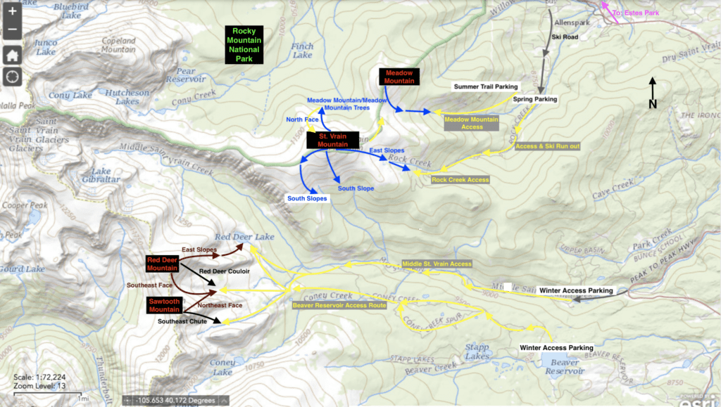
Overview map of St. Vrain Mountain’s backcountry ski lines
Ascent Lines:
As illustrated by the map above, there are no less than three access areas to the region, though the Rock Creek Access is by far the easiest for St. Vrain as it follows an old logging road to just below treeline. When covered in snow, the road is a fantastic way to skin up and ski back to your car.
Approach by taking Ski Road south out of Allenspark and driving it until you can’t. Do not take a right at the road junction to the St. Vrain summer trailhead. Once snow blocks your path, find a place to park (there are many opportunities just across Rock Creek), slap some skins on, and begin climbing.
The road will parallel the creek as it winds its way up to St. Vrain. Once it begins to switchback up a slope to the left of the creek, ~2.5 miles in, you’ll come to the most important decision of the ascent. Option one is to keep to the road as it winds its way higher, eventually ending on a shoulder of St. Vrain. From the shoulder, pick an ascending line through the trees, angling west-northwest and climbing past treeline to St. Vrain. Alternatively, when the road begins to veer away from the creek, head into the trees, maintaining the steeper drainage to your right until you break out of the trees at the bottom of the East Ridge run. From there, work your way as high as the snow coverage will let you.
St. Vrain Mountain Profile Picture. Photo by Timo Holmquist.
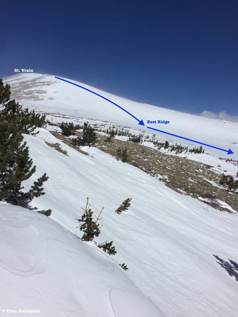
Photo of the backcountry ski line on St. Vrain Mountain’s East Ridge. Photo by Timo Holmquist.
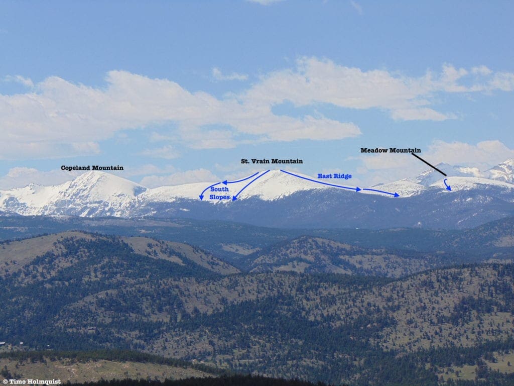
- St. Vrain: East Ridge
- Essentials: 3.7 miles, 3360 foot-vertical
- Status: Intermediate
- Steepest slope angle: 27 degrees
- Good for: A longer, albeit easy ascent on manageable terrain and a miles-long descent potential back to your car. This is a great, lower-risk environment for trying longer backcountry adventures.
- Accessed Via: Rock Creek Road, an approximately four-mile approach depending on how far you can drive up the valley.
- Halfway Variation: If the weather is threatening or the Front Range wind is particularly brutal, just navigate to the top of the road and ski it down. It’s still a long enough descent to get your legs pumping.
- At a Glance: 2.95 miles, ~2,000-foot vertical descent
- Steepest slope: 25 degrees
- Halfway Variation: If the weather is threatening or the Front Range wind is particularly brutal, just navigate to the top of the road and ski it down. It’s still a long enough descent to get your legs pumping.
- St. Vrain: South Slopes
- Essentials: 0.63 miles, ~1300-foot vertical
- Status: Intermediate
- Steepest slope angle: 35 degrees
- Good for: Skiing steeper lines on an open face. Easiest to combo with an East Ridge ascent for a longer day in the area. Increased avalanche risk due to steeper lines, though generally still low. Finding a line to skiers right of the summit will ease off the slope angle. Ski to treeline and hit pause. You have to re-ascend from the bottom to hit the East Ridge back to your car. In great conditions this line can provide another summit-direct descent. In later spring, coverage can be unreliable; if that’s the case, see the variation below.
- Accessed via: Rock Creek ascent route to St. Vrain summit. Turn south and sight an open slope below and slightly to the right (west) of the summit. Enjoy!
- South Shoulder Variation: If you’re looking for more variety, and a more consistent snowfield, ski west from the summit of St. Vrain to the top of the next broad shoulder. From here, turn left and ski down to treeline, enjoying a fresh take on the South Slopes route.
- At a glance: ~1 mile, 1240-foot vertical
- Steepest slope: 32-degrees
- South Shoulder Variation: If you’re looking for more variety, and a more consistent snowfield, ski west from the summit of St. Vrain to the top of the next broad shoulder. From here, turn left and ski down to treeline, enjoying a fresh take on the South Slopes route.
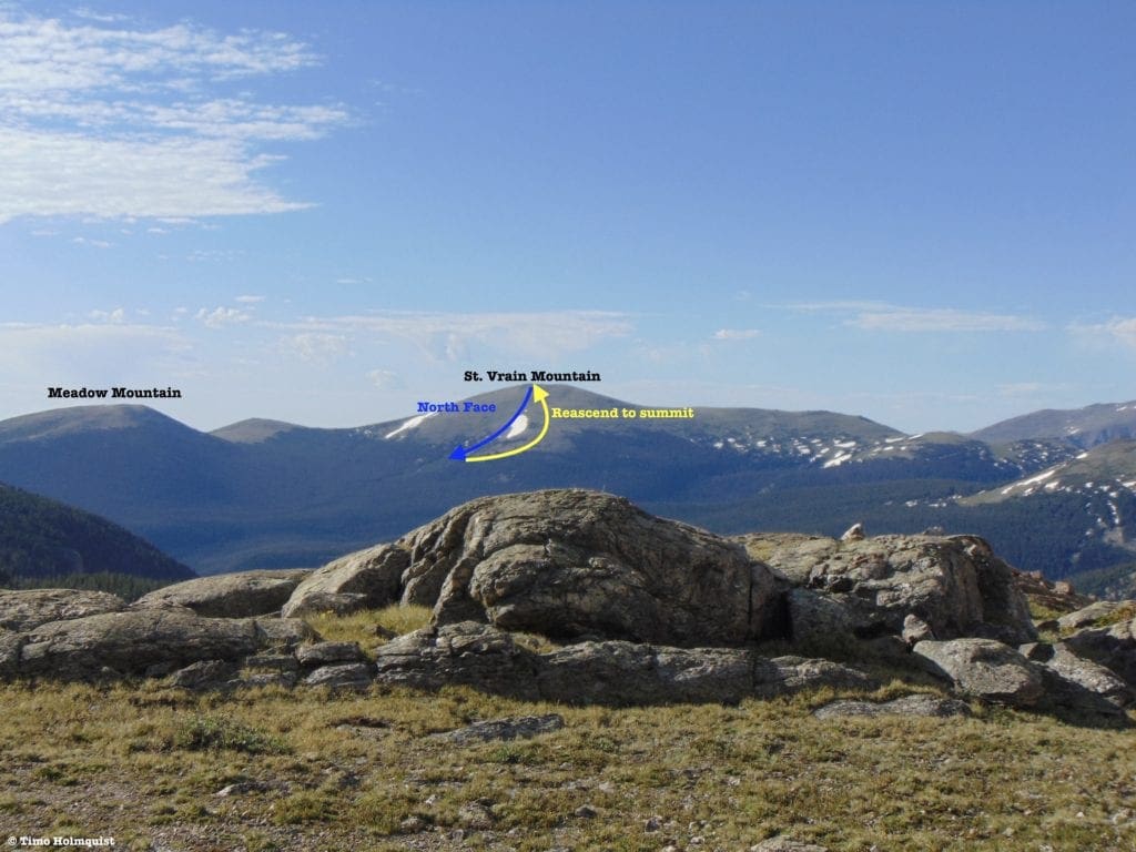
Photo of St. Vrain North Face from Wild Basin. Photo by Timo Holmquist.
- St. Vrain: North Face
- Essentials: 0.75 miles, 1500-foot vertical
- Status: Intermediate
- Steepest slope angle: 33-35 degrees
- Good for: Exploring the more isolated north side of St. Vrain. Absent the popular south side, north slope exploration lets you gaze into the mesmerizing Wild Basin. The slope is slightly steeper than the East Ridge and requires you to re-ascend a ridge to skiers left in order to regain the summit and your eventual descent back to your car.
- Accessed via: Rock Creek Road to treeline, East Ridge up to the summit, then a descent down an obvious and spacious face due north. Ski to treeline and then turn around to ascend. Keep in mind, the ascent statistics to St. Vrain’s summit are already ~3.7 miles and ~3600 feet climbed.
Ascent Lines cont.
As you drive down Ski Road from Allenspark, pay attention to the junction for the St. Vrain summer trailhead. If free of snow, take a right and make your way up to the parking lot. If covered, stop near the intersection and climb to the trailhead. This trail is a pleasant summer jaunt up to the bald summits of St. Vrain and Meadow Mountain. In the winter, it follows a creek drainage parallel to Rock Creek, eventually leading up to an open saddle with Meadow Mountain on the right, an unnamed lump to the left, and the larger summit of St. Vrain behind it. Due to its east and south-facing aspect, the top of Meadow Mountain is often patchy or free of snow, but the drainage you climbed up has some great powder stashes amongst the trees. Pick your starting line and descend the way you climbed.
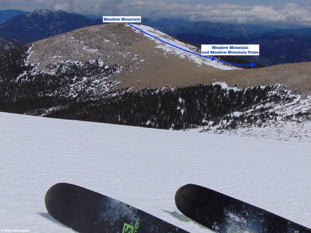
Photo of the backcountry ski line on Meadow Mountain from the East Ridge of St. Vrain. Photo by Timo Holmquist.
- Meadow Mountain/Meadow Mountain Trees
- Essentials: 2.6 miles, 2,700-foot vertical
- Status: Intermediate
- Steepest slope angle: 28 degrees
- Good for: Summit descent off Meadow Mountain in good conditions, well-spaced trees, and a well-traveled route back to your car. Watch out for tree-wells and as always, bring a friend.
- Accessed via: St. Vrain Summer Trailhead, or the signed junction before it if impassable to the trailhead. Take Ski Road south out of Allenspark and watch for St. Vrain trail signs. Skin up to the trailhead, find the trail start, and take it west to treeline and a Rocky Mountain National Park sign. Turn right and ascend to the top of Meadow Mountain. Ski down the way you climbed up.
Middle St. Vrain Drainage
The contrast between the Middle St. Vrain Drainage and the tame St. Vrain mountain is immediately apparent when looking at access routes. In many ways, it is better to make adventures into this isolated basin a multi-day effort. If determined to slam it in a day, be prepared for an alpine start and long haul back at the end of the day. Depending on the time of year, you may be out before sunrise and back to your car after sunset.
There are two approach routes though one has a few advantages. The first (and longer) option is accessed at a big curve on CO 72 at Peaceful Valley. Take road 92 west to Camp Dick. Here, if you don’t have a high clearance vehicle, stash your ride and begin a 3.6-mile journey to the Middle St. Vrain Trailhead. From there, connect with the Buchanan Pass Trail and make your way to Red Deer Lake to access some lines, or head south to connect with Coney Flats and access the rest of Red Deer Mountain and Sawtooth’s lines. This approach demands 5.3 miles and 1840 feet of elevation gain over rough terrain to Red Deer Lake (add another 2000 ft to the top of Red Deer Mountain). This approach is not recommended to Buchanan Pass.
The second and preferable approach (though still long) is to park at Beaver Reservoir. Off-road rigs can slowly proceed west, but it may be better to walk. Proceed from the reservoir for 3.2 miles to Coney Flats, then follow the summer route of Buchanan Pass until sighting your specified line. It is possible to access all of the lines on Red Deer and Sawtooth from Buchanan Pass. This approach will still cost you 6.5-7.5 miles and ~3373 feet of elevation gain to the top of Red Deer Mountain.
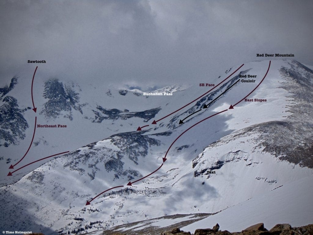
Photo of the backcountry ski lines on Red Deer Mountain. Photo by Timo Holmquist.
- Red Deer Mountain: East Slopes
- Essentials: 1.25 miles, 2000-foot vertical
- Status: Difficult
- Steepest slope angle: 35-37 degrees
- Good for: Long days in the backcountry with coherent skills, good company, and proficiency with avalanche mitigation gear.
- Accessed via: Beaver Reservoir to Coney Flats to Red Deer Lake. Ascend the East Slopes from the south side of Red Deer Lake. From Coney Flats, sight the long East Ridge of Red Deer Mountain and traverse towards it. The summer trail will be hard to find in this section: using the East Ridge as a marker is helpful. You’ll have to traverse around the ridge to find Red Deer Lake and the start of your slope climb.
- Red Deer Mountain: Red Deer Couloir
- Essentials: 0.65 miles, 1386-foot vertical (+ ~500 vertical feet for the runout to Coney Flats)
- Status: Very Difficult
- Steepest slope angle: 47 degrees
- Good for: A challenge deep in the heart of the North Indian Peaks. Bail-out options are few, but when filled, the couloir is an absolute treat. The apron at the bottom provides some relief but avalanche danger in the couloir is high, keep watch for cornices and crowning. NOT for beginners or intermediate skiers, backcountry skills, and avalanche mitigation gear necessary. Mountaineering gear necessary if climbing the couloir bottom to top, can be avoided by ascending from Buchanan Pass first.
- Accessed via: Beaver Reservoir to Coney Flats to Buchanan Pass. From Buchanan Pass head north to the top of Red Deer Mountain. Pass by the summit (heading east) and sight the couloir as it descends east-southeast towards your ascent route. Note: Buchanan Pass’s eastern side has some cornices, and the western side may be sparse, forcing a ski carry. However, it is much safer than the avalanche terrain below.
- Red Deer Mountain: Southeast Face
- Essentials: 0.87 miles, 1500-foot vertical (+ 500 vertical feet back to Coney Flats)
- Status: Difficult
- Steepest slope angle: 39-40 degrees
- Good for: An alternative to the mellower East Slopes and harder Red Deer Couloir. Coherent backcountry skills necessary, and avalanche gear is a must. NOT for beginners or intermediate skiers. Plan for a long day in the backcountry.
- Accessed via: Beaver Reservoir to Coney Flats to Buchanan Pass. As you approach the pass, look to Red Deer Mountain (north) and start sighting suitable descent lines off the ridge between the pass and the summit. There are MANY possible variations, generally trending more difficult the closer they get to Red Deer’s summit. Note: Buchanan Pass’s eastern side has some cornices, and the western side may be sparse, forcing a ski carry. However, it is much safer than the avalanche terrain below.
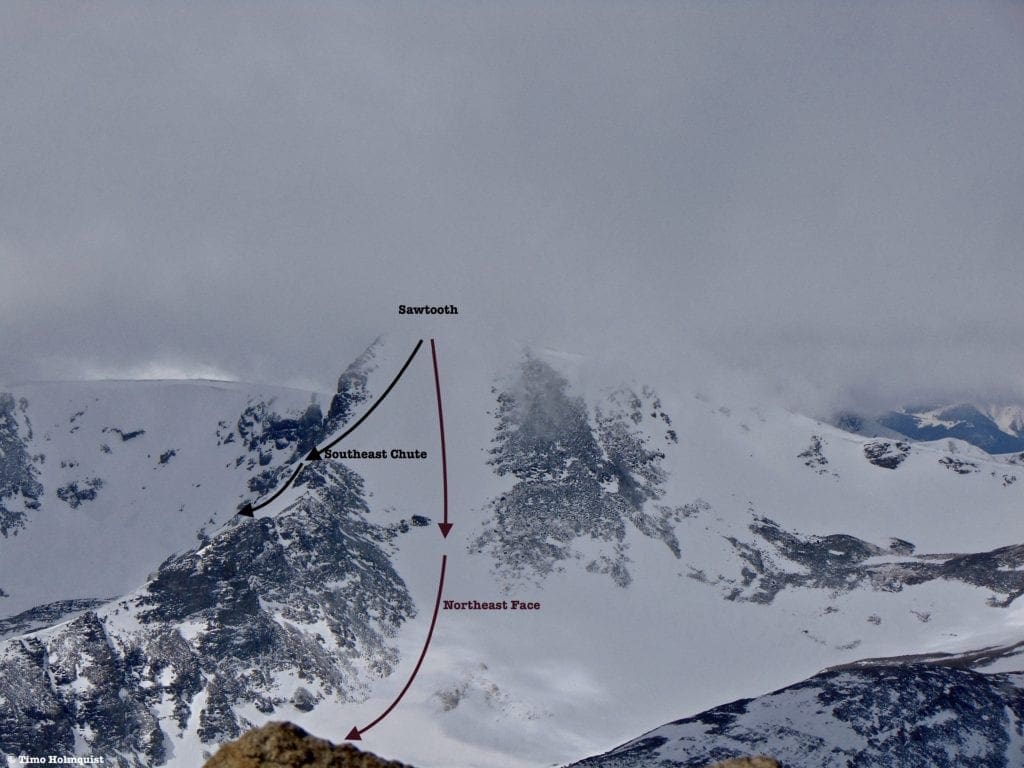
Photo of the backcountry ski lines on Sawtooth Mountain: Northeast Face. Photo by Timo Holmquist.
- Sawtooth Mountain: Northeast Face
- Essentials: 0.84 miles, 1500-foot vertical
- Status: Intermediate
- Steepest slope angle: 40 degrees (brief at the top before mellowing to a consistent low 30s-degree angled run)
- Good for: Skiing one of the classic Indian Peaks Lines. The effort to get back here is massive and may require long-distance ski carry’s. Coherent backcountry skills are necessary including a full complement of avalanche gear and a ski partner. NOT for beginners.
- Accessed via: Beaver Reservoir to Coney Flats to Buchanan Pass Trail. You can take the trail to Buchanan Pass and head south or climb the route from the bottom for additional beta on how it will ski.
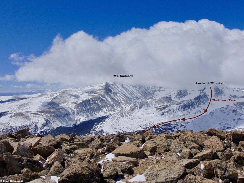
Photo of the backcountry ski lines on Sawtooth Mountain: Northeast Face. Photo by Timo Holmquist.
- Sawtooth Mountain: Southeast Chute
- Essentials: 1.5 miles, 2000-foot vertical
- Status: Very Difficult
- Steepest slope angle: 48 degrees
- Good for: A quick, tough challenge with two components that receive early morning sun. The best way to ski this line is to camp nearby and hit the line early before melting causes problems.
- Accessed via: Beaver Reservoir to Coney Flats. Begin by taking the Buchanan pass trail around a long low ridge after the Coney Flats area. On the other side of this ridge, you will cross two creeks. The area between these two creek crossings is where you need to leave the trail and head east-southeast into your target basin. While you can use Buchanan Pass to get to the top of the route, due to its sun exposure and the lack of visibility on the approach it is highly recommended you climb the route from bottom to top to accurately assess conditions. If it’s a mess, once you top out on Sawtooth, you can take the Northeast Face down Buchanan Pass Trail. Watch for thin coverage, rock exposure, and slushy conditions if attempting this line later in the day.
Quick Terminology Reference Guide
- Apron: An open section of a ski line, shaped roughly like an apron. It is generally shallower at the top, wider at the bottom.
- Bootpack: A way to gain elevation utilizing the tough exterior of ski boots, literally creating steps in the slope with your ski boots. Only effective in mid-winter conditions with softer snow. Once ice forms, crampons, and an axe are best.
- Buttress: A support structure in architecture. In mountain talk, it is a large, often steep set of rock walls that juts out from a mountain massif and acts as an impediment (or rock-climbing opportunity) on an ascent. A buttress does not have to be immediately connected to a summit but it is abrupt.
- Bergschrund: Unlike a crevasse, which tends to form in the middle of a glacier, a bergschrund, or “schrund” for short is a crack or separation that forms between the top of a glacier and the mountain slope or stagnant snow behind it.
- Chute: An inset area along a ridge that can hold great snow and presents like a natural ski run.
- Cirque: an amphitheater shaped head of a glacial valley, usually steep.
- Cornice: An overhung area of snow that typically forms at the crest of a ridge or cirque. While the corniced ice and snow looks compact, there is usually nothing holding it up underneath; your weight alone can collapse a cornice. A collapsed cornice may also lead to avalanches. Do not stand on the edge of a cornice or climb directly beneath one.
- Couloir: Originally a French alpinist term, a couloir is a thin skiable chute. They are typically a no fall zone and challenging to ski effectively.
- Crevasse: A large crack that usually forms on glaciers during warmer times of year as the compact ice shifts. Very dangerous if fallen into.
- Crown: The vertical fracture line that appears after a slab avalanche, indicative of unstable terrain.
- Crux: Typically, the most dangerous section of an ascent or descent. Difficult routes can have multiple cruxes. A NO FALL ZONE.
- Glade: A treed area of a particular slope or line.
- Headwall: A topographical term used to mark where a basin, gorge, or alpine valley ends. Headwalls are usually steep and can sport multiple couloir options.
- Line: The chosen path of skiers and snowboarders.
- Pillows: Created when deep snow buries boulders, super fun to bounce between.
- Runout: The bottom of a ski line, especially after a thin section or couloir, where the slope opens up. Similar to an apron.
- Skin track: The route you use to ascend a slope, very important for backcountry navigation.
- Terrain Trap: An area where snow from an avalanche can collect and bury a victim. More broadly an area where it is difficult to ski out of once entered.
- Wind-Slab: An area of compacted snow: formed by gusty winds. If near a steep slope, they can collapse and cause avalanches. Wind-slabs are often called wind-loaded slopes as well.
Final Thoughts
St. Vrain is an excellent test piece for the Indian Peaks. The long approach and wind-swept summit are great low-risk places to earn some turns, and with variations to the East, South, and North, multiple laps in the area can be made. While not as quick as Hidden Valley in Rocky Mountain National Park, the extra effort is worth the absolutely stunning summit views and long, casual descent back down Rock Creek.
Conversely, Red Deer and Sawtooth stand guard over a particularly lonely section of an exceptionally popular wilderness area. Parties that venture into the area will be gifted long runs and a good chance for solitude, a relative rarity considering the closeness to Denver and Boulder. Consider giving both areas a multi-day treatment to take full advantage of all the line possibilities between both peaks.
As always, tie your adventures to safety. If the local knowledge is lacking, weather is threatening, or you have an unfavorable avalanche forecast, consider venturing out at a different time. The mountains will still be there when you return, and successful risk management allows us to enjoy them year after year. Be safe and have a blast out there!
Additional Resources:
AIARE, Avalanche Research Education. (n.d.) Retrieved from https://avtraining.org/
Allenspark Lodge Bed and Breakfast. (2014) Retrieved from https://allensparklodgebnb.com/
Colorado Avalanche Information Center. (n.d.) Retrieved from https://www.avalanche.state.co.us/
Colorado University. Mountain Research Station. (n.d.) Retrieved from https://www.colorado.edu/mrs/
- Niwot Ridge Weather. (n.d.) Retrieved from https://www.colorado.edu/mrs/current-events/niwot-ridge-weather
Front Range Ski Mountaineering. (n.d.)
- Vrain Mountain. Retrieved from https://www.frontrangeskimo.com/saintvrainmountain/
- Red Deer Mountain. Retrieved from https://www.frontrangeskimo.com/red-deer/
- Sawtooth Mountain. Retrieved from https://www.frontrangeskimo.com/sawtooth/
LyonsColorado.com. (2021). Lodging. Retrieved from https://lyonscolorado.com/plan/lodging
Mountain Forecast. (n.d.) Mt. Audubon Forecast. Retrieved from https://www.mountain-forecast.com/peaks/Mount-Audubon/forecasts/4135
National Weather Service
- Allenspark Extended Forecast. (n.d.) Retrieved from https://forecast.weather.gov/MapClick.php?CityName=Allenspark&state=CO&site=BOU&textField1=40.2&textField2=-105.52&e=0#.YFIi9rRKjOQ
Powder Project. (n.d.)
Caprarella, Tcaprare. Meadow Mountain Trees. Retrieved from https://www.powderproject.com/trail/7000765/meadow-mountain
Sunshine Mountain Lodge. (2021) Retrieved from https://www.sunshinemtnlodge.com/
VisitEstesPark.com. (2021). Lodging. Retrieved from https://www.visitestespark.com/lodging/
USDA: Natural Resources Conservation Service, National Water and Climate Center. (n.d.) Snotel Interactive Map.
Written by Timo Holmquist.
Timo Holmquist is an outdoorsman, a creative writer, and a tourism industry professional based in Boulder, Colorado. Timo’s main writing topics include hiking, the outdoor lifestyle, skiing, tourism, and travel.
Best Options For Technical And High-Altitude Climbs During the Pandemic
Backcountry Ski Gear: Essentials for Human Powered Skiing
Guide To Planning A Backcountry Ski Adventure
Backcountry Skiing in Rocky Mountain National Park: Hidden Valley and Sundance Mountain Ski Lines
Backcountry Skiing in Rocky Mountain National Park: Bear Lake Area Ski Lines
Backcountry Skiing in Rocky Mountain National Park: Longs Peak Area Ski Lines
Best Places To Backcountry Ski in Rocky Mountain National Park, Colorado: Best of the Rest
Remote Backcountry Ski Lodges in British Columbia
SKYBLUEOVERLAND.com, should you choose to go backcountry skiing, do so at your own risk. Prior to setting out check current local weather, conditions, and land/road closures. While taking a trail, obey all public and private land use restrictions and rules, carry proper safety and navigational equipment, and of course, follow the #leavenotrace guidelines. The information found herein is simply a planning resource to be used as a point of inspiration in conjunction with your own due-diligence. In spite of the fact that this guide was prepared under diligent research by the specified contributor and/or contributors, the accuracy of such and judgement of the author is not guaranteed. SKYBLUE OVERLAND LLC, its partners, associates, and contributors are in no way liable for personal injury, damage to personal property, or any other such situation that might happen to individuals following this guide.


