


|
Getting your Trinity Audio player ready...
|
Introduction
Herman Gulch is a very popular summer hiking area with a convenient trailhead right off I-70 near the Loveland Ski Area in Colorado. It can also be a fantastic haven for backcountry skiing. In this article, we’ll dive into Herman Gulch and its neighbors, Watrous and Dry Gulch.
Sandwiched between the über popular Loveland and Berthoud Passes are a series of mountains on and adjacent to the Continental Divide that can provide exceptional backcountry turns. You don’t get a good look at all the options while traveling up I-70, although both US 6 over Loveland Pass and US 40 over Berthoud give glimpses of their massive potential. Some of the best lines require a little more commitment to get to, but that commitment is still miles less than comparable areas like the IPW before summer access opens up. Only an hour separates Herman Gulch from the Denver suburbs, and with that kind of convenience, it’s worth spending some time to get into the area.
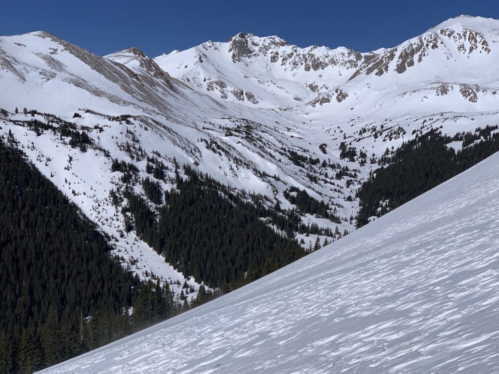
Looking up Herman Gulch.
Quick Navigation
Article Navigation: Click on any of the listed items in the table of contents below to jump to that section of the article. Similarly, clicking on any large, white section header will jump you back to the Table of Contents.
- Backcountry Gear
- Backcountry Planning
- Area Overview
- Watrous Gulch
- Lower Herman Gulch
- Upper Herman Gulch
- Dry Gulch
- Maps and Extras
- Additional Resources
Ridgelines above Dry Gulch.
Backcountry Gear
Let’s lay out some quick backcountry gear knowledge (for a more comprehensive guide, check out our article, Backcountry Gear: Essentials for Human Powered Skiing). The list below is crucial, don’t skimp on gear when avalanches are in play.
- Skis/Helmet/Gloves/Goggles
- Winter Clothing: waterproof shells, thick ski socks, layers, puffy, beanie, hand warmers, etc.
- Skins
- AT Bindings (Frame or Tech)
- Avalanche Gear: Beacon, Shovel, Probe, and Radio
- Backcountry ski pack
- Food/Water/First-Aid Kit
- For multi-day adventures: 4-season tent, winter rated sleeping bag, avalanche airbag, orienteering equipment, batteries/rechargeable batteries
- Mountaineering Axe and Crampons. While there are hundreds of lines that do not require these tools, some of the most epic lines do. Research which crampons fit over your alpine or tech boots before buying! Generally speaking, you do not need an “Ice” axe unless you are climbing an ice wall; a mountaineering axe should work fine for most couloirs. However, some of the hardest ski mountaineering routes in the area demand more. Analyze your skill level and the route of choice BEFORE settling on gear options.
Remember, it isn’t enough to simply own gear; take the time to figure out how to use it before heading out. Speed is key, especially in a backcountry avalanche rescue. Visit Backcountry Gear: Essential for Human Powered Skiing to get comfortable with the necessary gear and how to use it.
Looking south to Loveland Pass from the slopes of lower Herman Gulch.
Backcountry Planning
Once you have the gear and know how to use it, it’s time to start planning. We’ll briefly break down the central components below, but check out our Guide to Planning a Backcountry Ski Adventure for an in-depth analysis of the planning process. A good plan can separate success from disaster. No outdoor activity is worth your life.
- 1) Pre-Planning
-
-
- Learn how to Ski at an EXPERT level before heading outside ski resort boundaries. Find a squad. Start backcountry gear research. Hone your craft. Get in shape.
-
- 2) Long-Term Planning
-
- Geographic reduction: where are you skiing? Start big, get small.
- Weather and snowpack research.
- Research ski lines using books, online resources, and forums. Key data:
- Total distance, total climb, total descent, slope angle
- Local Emergency contacts
- Unique factors: trees, cornices, couloirs, avalanche history
- Get into the maps and apps, know the area like the back of your hand.
- 3) Short-Term Planning
- Managing Expectations
- Constantly check weather updates until the morning you leave. Remember, snow reflects light, if it’s a sunny day, bring sunscreen!
- Popularity of your backcountry line.
- Tell people where you’re going and who to call if things go wrong.
- Have a back-up plan.
- Who’s got the medical training?
- Go over the plan in detail with your squad. CHECK FOR UNDERSTANDING.
- Packing
- Make sure everything fits, and you can access your avalanche gear quickly. Time is critical in a burial situation.
- Managing Expectations
- 4) On-site Planning
- What do you see when you get there?
- Watch out for tree-wells, wind-loaded slopes, cornices, bergschrunds, and other topographical considerations.
- Timing and snow surface i.e. environmental factors. Not all snow skis the same.
- What do you see when you get there?
- 5) Post-Planning
- Analyze
- What worked well? What didn’t?
- Ease into the harder stuff.
- Analyze
The steps listed above are only a skeleton outline; see our Guide to Planning a Backcountry Ski Adventure to iron out the critical details. Remember, you can always take an avalanche safety course through AIARE; it can absolutely save lives.
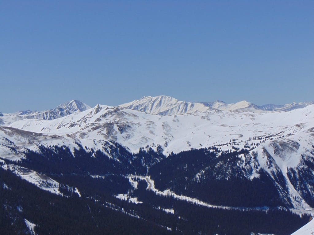
Fresh lines on Hagar Mt.
Area Overview
A compact area with plenty to offer, the Herman Gulch region is best accessed via the Herman Gulch Trailhead, exit 218 on I-70. From there, you can utilize two well-established trails to head into either Herman or Watrous Gulch. Dry Gulch, which lies on the southwest side of Herman, also has a few great skiing options. Between all three, you can spin laps for weeks without getting bored.
The Clear Creek drainage, which I-70 follows through this part of the mountains, tends to melt out a lot faster than the surrounding gulches and peaks. If it’s dry all the way up to the trailhead, don’t panic, there will be skiable snow in the gulches until early summer. With careful planning, some of the lines in this area can be skied mid-winter but be aware of avalanche danger and always check the weather before you go.
The wind really howls through this part of Colorado when winter storms roll through. Many western and some northern slopes remain wind stripped and bare throughout the winter, only filling in with spring upslope snow. Luckily, the wind throws the snow into dependable options on southern and eastern slopes, which provide the most consistent skiing.
Elevations near Herman Gulch range from 10,300 feet at the trailhead to 13,580-foot atop Mt. Parnassus.
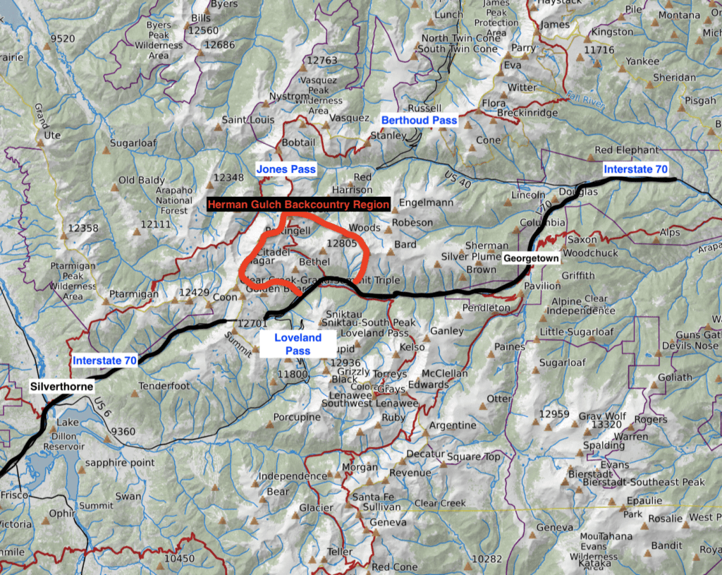
Herman Gulch area overview map.
Watrous Gulch
Smaller than Herman Gulch, Watrous Gulch is great for repeatable laps or a quick half-day ascent/descent. The options here contain mellow and moderate lines, which are perfect for beginner backcountry skiers. Please note that the Watrous Gulch trail breaks off from the Herman Gulch Trail about 0.2 miles from the parking lot. Due to beetle kill, the lower parts of Watrous Gulch are dry and sun-exposed; when you get into the actual gulch, snow should be deep and plentiful through mid-late May.
From the parking lot, find the main Herman Gulch kiosk and walk/ski up the trail. Once you find the junction with Watrous Gulch (evidenced by an obvious USFS sign), take a right. The next few points of a mile could be dry; be prepared to ski carry. After gaining a few hundred feet and a little more than a mile, the trail heads into Watrous Gulch. Once you connect with the gulch, the trail will likely disappear under the snow. There are usually other tracks for you to follow, but if not, you can traverse travel along the bottom of the gulch for easy skinning.
Take a second on the approach to note where you either lose the official trail, or where you connect with Watrous so as not to miss the connection on the return. Unless you’re in white out conditions, the massive bulk of Parnassus should be visible lining the eastern side of the gulch (your right side as you ascend).
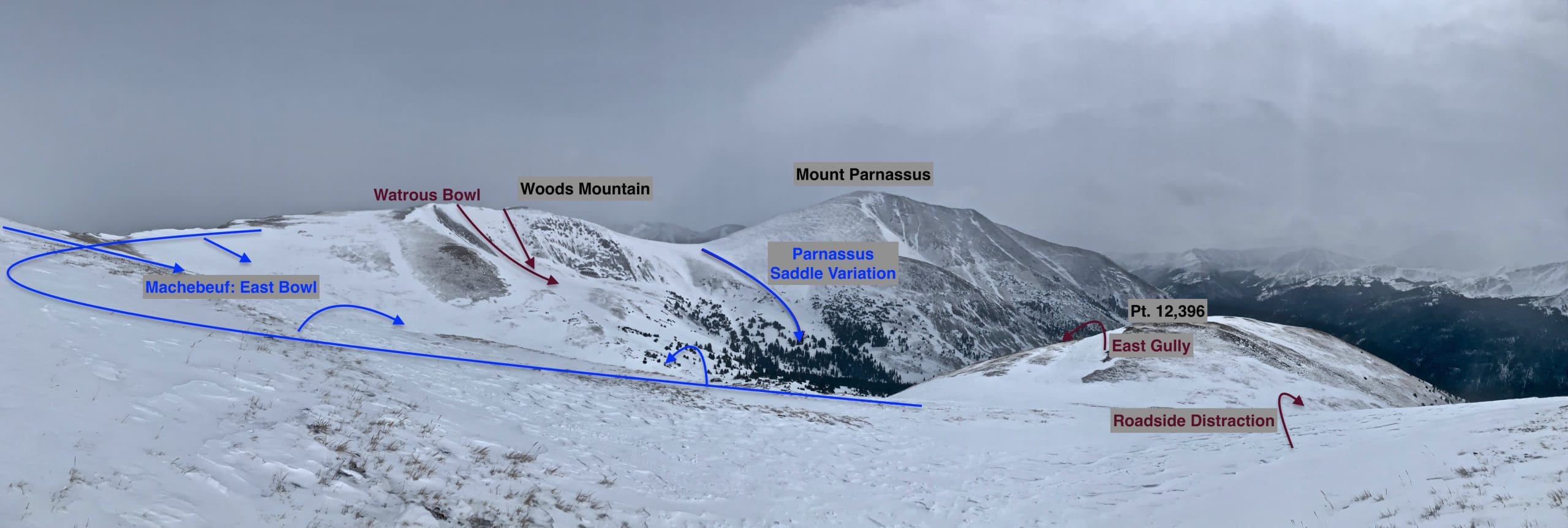
Watrous Gulch panorama.
- Pt. 12,396 East Gully
As you start ascending into Watrous, trees will block your view to the left. A GPS watch is helpful (or a detailed map) to help you determine when you reach an elevation around 11,400 ft. (39.71910, -105.84079). From there, begin ascending almost directly due west up the slopes. Once you break treeline, take stock of where you are.
Pt. 12,386 is really a shoulder of the larger Mt. Machebeuf but distinguishes itself from the latter via a small smattering of wind-loaded couloirs that drop into pleasant tree skiing all the way back down to Watrous. This area is steeper than the East Bowl of Machebeuf but faster to get to.
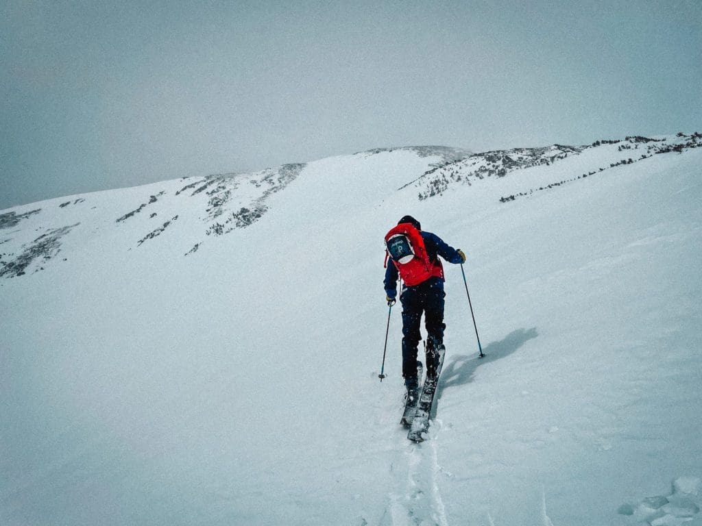
Skinning up with the East Gully looming behind.
There are two ways to climb to the start. You can climb the gully directly, which will involve either a boot pack or spikes, or you can sight the gully and traverse north to the ridge separating this area from the main East Bowls of Mt. Machebeuf. Locate the ridge by sighting a few rocky ridge highpoints interspersed with krummholz.
Skinning along the ridge crest, or just north of the crest if it’s windswept, should give you a much easier ascent.
- Essentials: 0.63 miles, ~1000 ft. vertical back to Watrous Gulch
- Status: Difficult (but quickly moderates)
- Steepest Slope Angle: ~36 degrees briefly
- Good for: Half-day excursions and as part of a larger Watrous Gulch exploration. The eastward orientation means this area can absolutely haul in wind-drifted powder, which makes it great to ski with fresh snow.
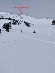
Looking up at the top portion of the Pt. 12,396’s East Gully.
- Mt. Machebeuf East bowl
Instead of ascending to reach Pt. 12,396, continue heading due north along the bottom of Watrous Gulch until reaching treeline. From here, a continuation north will bring you to Watrous Bowl on Woods Mt. What you’re looking for is the Machebeuf East Bowl, a large, friendly area northwest of you.
You can either follow the lower part of the drainage northwest into the expansive bowl (from roughly 39.71973, -105.84115) or copy the ridge ascent for Pt. 12,396, continuing up the ridge beyond the East Gully until reaching the highest point. Once reached, take your pick of dozens of line possibilities that all funnel east back down to Watrous Gulch.
- Essentials: ~0.9 miles, 1350 ft. vertical to Watrous Gulch
- Status: Moderate
- Steepest Slope Angle: 32-33 degrees (brief)
- Good for: Skiing an expansive bowl with no real topographical hazards until you get back toward treeline. Near the bottom of the run, make sure to note any windswept areas as they may be hiding sharp rocks that could mess up your skis.
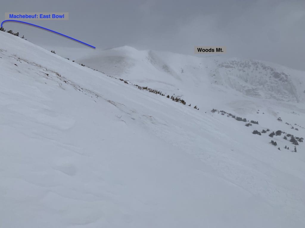
Showing the edge of the East Bowls from the ridge ascent.
- Woods Mountain-Watrous Bowl
Once you reach treeline in Watrous Gulch, stay on a largely northern trajectory and climb to a bench in front of Woods Mountain. Unobstructed views of the Watrous Bowl from here should help you pick your descent line. There are a few options to choose from. As with most new areas, it is always recommended to climb the route before skiing it; however, an ascent up the East Bowl of Machebeuf to the ridgeline and then traversing to the top of the bowl is not a bad alternative.
There are two reliable lines in Watrous, with more options depending on snowpack coverage. As previously indicated, this part of the Front Range experiences intense wind stripping, so you may be confined to the two suggested lines. The top few hundred feet are big mountain skiing but look steeper than they actually are. Short to medium turns are the way to go if wind stripping has left a lot of the face bare.
- Essentials: ~0.8 miles, ~1400-1500 ft. vertical to Watrous Gulch
- Status: Difficult
- Steepest Slope Angle: 35-37 degrees
- Good for: Skiing a big mountain line without it being face-meltingly steep. The line closest to the summit is the steeper of the two, and in-between the lines is only skiable after a large accumulation.
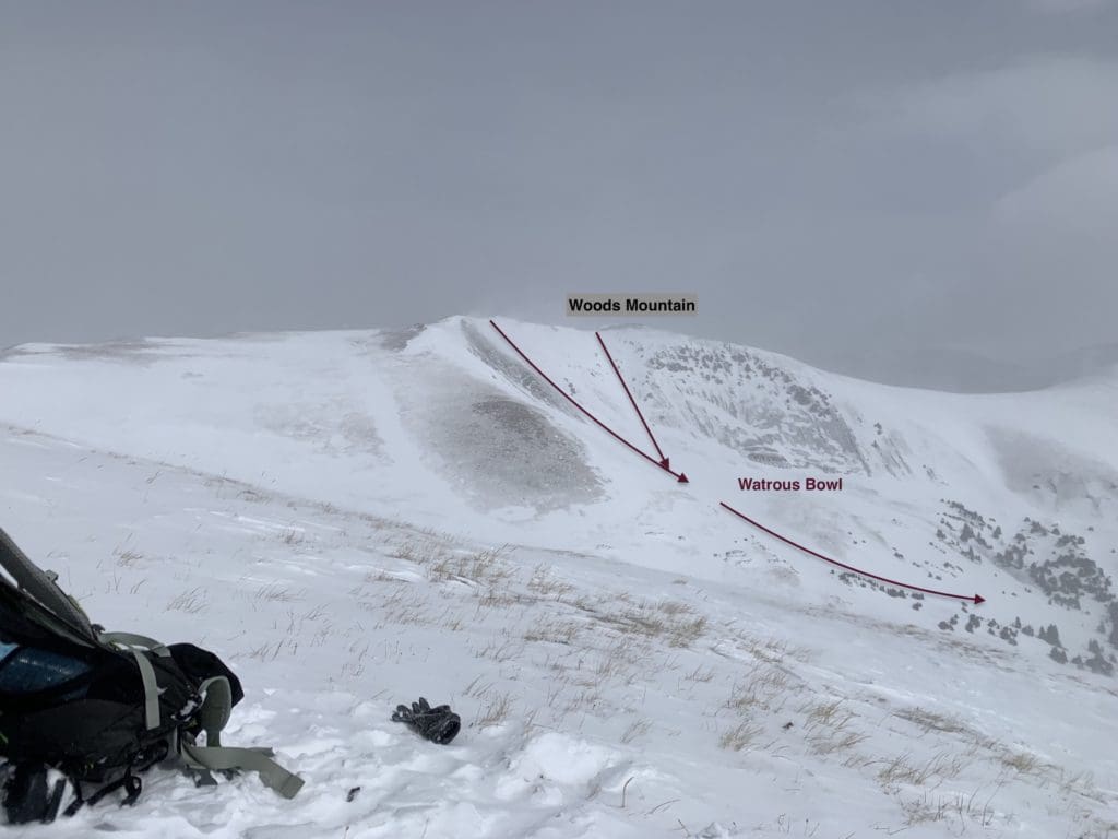
Watrous Bowl.
- Parnassus Saddle Variation
This line is an interesting take on a seldom-skied slope. There are significant wind-blasted areas around this saddle, so avoiding them is a priority. With a slope angle that never gets to 30 degrees (unless you hunt for steeper terrain), this line, coupled with Machebeufs East Bowls, can be a great introduction to backcountry skiing.
From Watrous Gulch, make your way toward treeline as you would for Watrous Bowl. Instead of continuing north, at around 11,400 ft. (39.71910, -105.84079), start ascending to the northeast through an initially thick and then increasingly sparse bit of trees. The trees end fairly quickly, allowing you (in good visibility) to see the bulk of Parnassus to your right and Woods Mountain to your left. Ascend the gradual slope to the saddle between the two, noting areas that have been wind-blasted, and ski down what you ascended.
- Essentials: ~0.65 miles, ~1000 ft. vertical to Watrous Gulch
- Status: Easy/Moderate
- Steepest Slope Angle: 26 degrees
- Good for: Beginner backcountry skiers trying out the discipline. Probably a little too mellow for veterans.
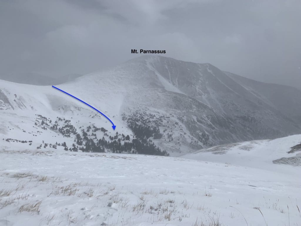
Parnassus saddle variation
Lower Herman Gulch
Surprisingly long, Herman Gulch contains a great set of ski lines that are fun and repeatable. Be aware that on weekends, especially in good spring weather, the parking lot will get full unless you arrive very early. Once you’re situated, find the kiosk and begin huffing it up the trail. When you hit the first trail junction, make sure to stay left to continue into Herman Gulch.
Like the Watrous approach, there may be some areas of the trail down low that do not have continuous snow. Once you get to roughly 10,800-11,000 ft., snow should be more continuous through early-mid May. The lower Herman Gulch area, including all three lines from Mt. Machebeuf (officially listed as Pt. 12,805), should be skied from March-late-April. The upper Herman Gulch area can remain skiable through May and sometimes June during above-average snowfall years.
Lower Herman Gulch and the bulk of Parnassus from Hagar Mt.
- Mt. Machebeuf: Roadside Distraction
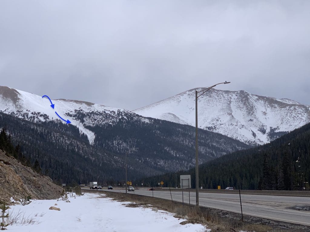
The southern and western slopes of Mt. Machebeuf (on the map as pt. 12,805) contain three excellent lines; the first one you run into is Roadside Distraction. The peculiar name is given because of the view you get driving eastward on I-70. Once you get through the tunnels and pass the exit for Loveland Pass, look ahead, and down the highway, you should see a broad strip of snow extending up to a high mountain shoulder above you and to the left.
Because of its southern orientation, this line can heat up and turn into a slushy mess on hot days. It is usually the first line to melt-out in Herman Gulch. It’s best to ski this one early in the day and earlier in the year. Because the avalanche path crosses the trail less than a mile into your journey, it should be easy to find. The bottom of the line is around 10,800 feet (39.70918, -105.85812).
If this is your first time in the area, its best to climb the slide path from the bottom. If you’re familiar with Watrous Gulch, you can use the approach to the top of Pt. 12,396 and the East Gully. Instead of skiing down the East Gully, move across the ridge crest to the west until you sight the avalanche path below you and ski it down to Herman Gulch.
- Essentials: 0.8 miles, ~1700 ft.
- Status: Moderate
- Steepest Slope Angle: 31-32 degrees
- Good for: Early spring laps when other aspects may be too dangerous to try. The bottom of this line melts out quicker than a lot of others in the area, so a window from March to early April is likely best for the most continuous skiing.
The Roadside Distraction line from the side of I-70.
- Mt. Machebeuf: Central Gully
This is likely the hardest of the three Machebeuf lines into Herman Gulch. The slope isn’t very recessed, so a series of wind storms can whisk away a lot of the fun powder. If you manage to hit it in good conditions (ideally a day or two after a storm with low avalanche potential), this can be a good challenge with easy access to Machebeufs summit from the top of the line.
Stay on the Herman Gulch trail as you pass the exit for the Roadside Distraction line. Soon after, you’ll pass a second avalanche path leading up and to the right. This is the Central Gully route. As with Roadside Distraction, the southern orientation is a mixed bag. It’s often more stable than other wind and cornice-loaded slopes but will melt out earlier than northern and eastern slope aspects. When it does start to melt, a series of small cliffs in a narrow part of the path, roughly 1/3 of the way up, present a logistical challenge. Again, a good timeframe is March to late April with low avalanche potential.
- Essentials: 0.65 miles, ~1770 vertical feet back to Herman Gulch
- Status: Difficult with additional rock hazards after a period of melting
- Steepest Slope Angle: 36-38 degrees
- Good for: Early, stable spring skiing down a thin couloir with killer views. NOT for beginners.
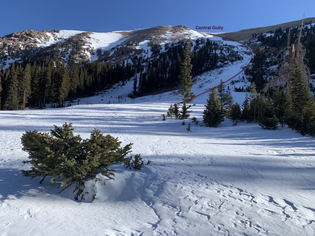
Central Gully from the bottom.
- Mt. Machebeuf: I.V. Drip
Of the three Machebeuf gullies, I had the most fun on this one. Like the other two, the bottom is thinner, but unlike the others, this one appears to hold snow better, allowing for relatively unencumbered turns all the way down to the Herman Gulch Trail. The best timeframe is still March through mid-April.
After passing the bottom of the Central Gully, continue along the base of Herman Gulch. A rocky ridge will make itself known to your right and blocks views into the route initially. Once you pass the ridge, an obvious avalanche chute (the third you’ll see from the trailhead) heads up to the right. This is your line.
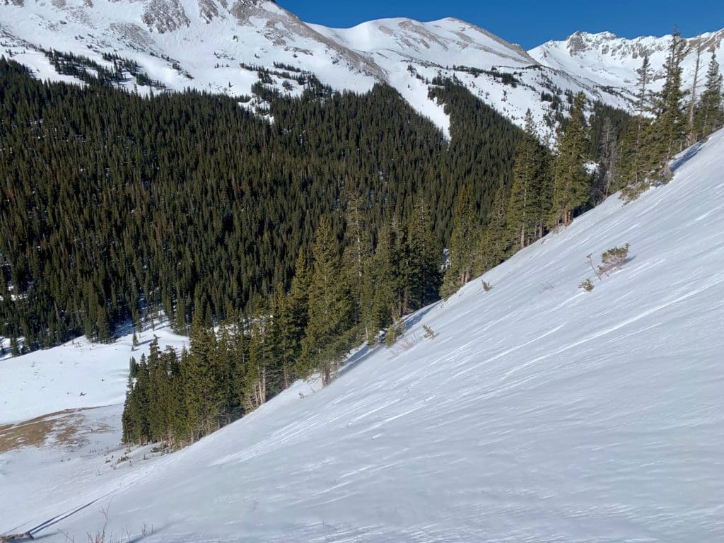
The steepest portion of the line is at the bottom.
It helps to boot pack or spike up the steeper, lower portion, where 250 vertical feet or so puts you into the mid-30s in terms of slop angle. Once you pass this, the slope balloons out in size and decreases in steepness. Be aware of sneaky cornices forming on the west (climbers left) as you head higher. Under a stable snowpack, these features would be fun to jump, but if the avalanche danger isn’t low, better to stick to the main face.
- Essentials: 0.54 miles, ~1400 vertical feet back to Herman Gulch
- Status: Difficult, slide potential on climbers left (skiers right)
- Steepest Slope Angle: 36 degrees
- Good for: Early, stable spring skiing down an aesthetically pleasing gully with killer views. NOT for beginners.
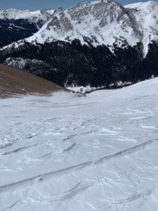
You’ll eventually end up where the circle is in the picture, some 1400 feet below you.
Upper Herman Gulch
The Upper Herman Gulch area covers ski lines on Pettingell Peak and the Citadel, although it should be noted that one particular line from the Citadel is best accessed via Dry Gulch and will be discussed in that section.
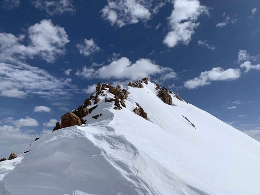
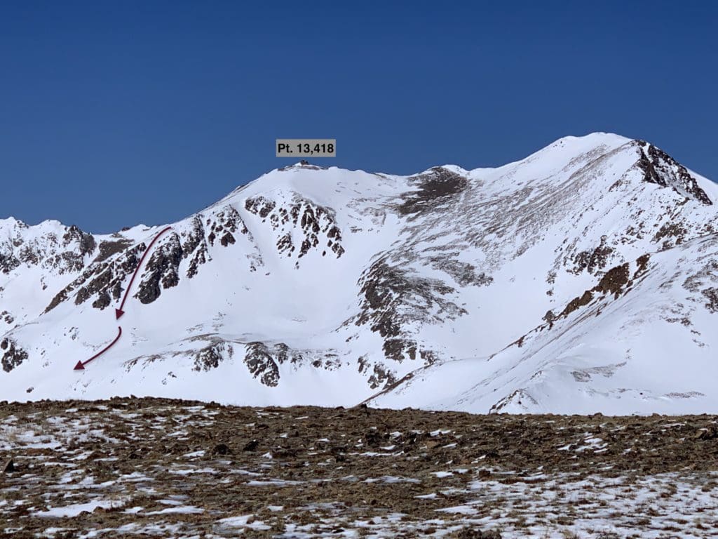
Pettingell Peak is the monarch of Herman Gulch and has a fantastic view from its summit. As far as ski lines are concerned, the upper part of the mountain only has one seasonal option that needs a good storm to make it skiable. Due to its variable nature, I’m going to focus on the most reliable skiing options on Pettingell, which all take off from a shoulder of the mountain called Pt. 13,418.
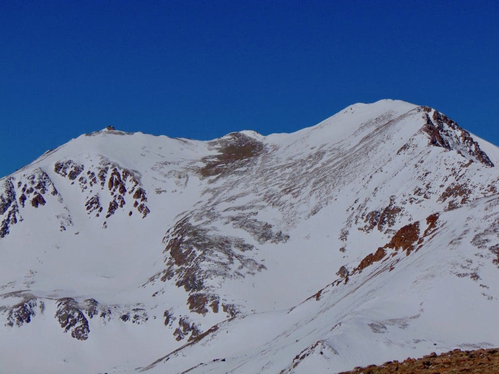
The upper, windswept part of Pettingell is not always in season, but its snowy shoulder to the left is reliable through the spring.
The Citadel may be smaller than Pettingell, but it is twice as dramatic, with duel rocky summits that demand a tough scramble in the summer to attain. The peak (along with Hagar Mountain) is very visible from various points at Loveland Ski Resort, most prominently around the Chet’s Dream Lift. From this vantage point, the mountain looks like Snoopy lying down on his house, with the western summit acting as his upturned nose and the eastern summit positioned as his belly. Therefore, the most prominent lines off of the Citadel have Snoopy in their name.
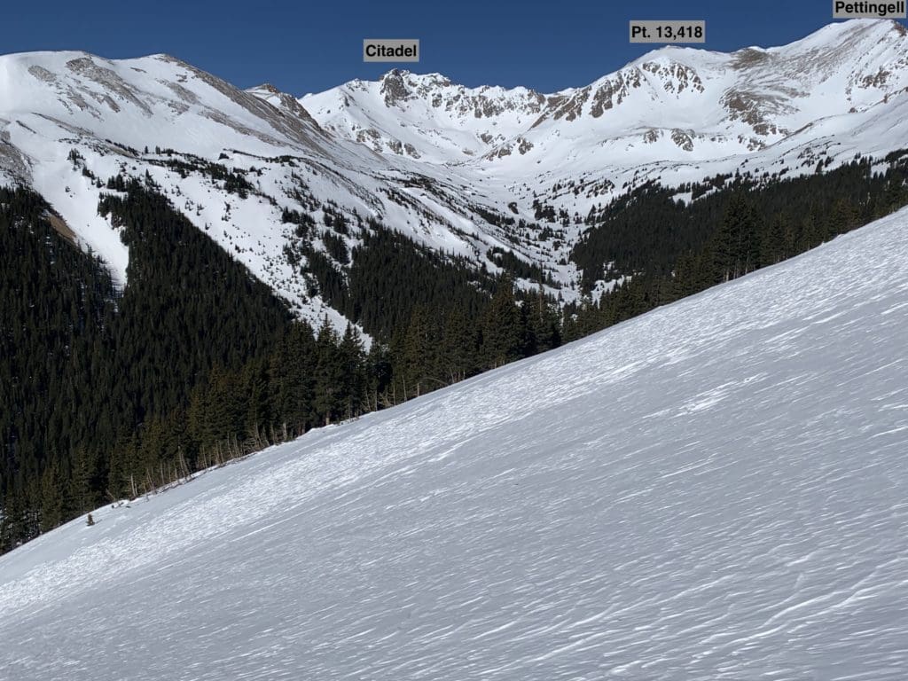
Upper Herman Gulch from down valley.
- Pt. 13,418 Bow-Leg
As indicated above, the most fun skiing is off of Pettingells shoulder (pt. 13,418), where two couloirs and a gentler face stay snowy for much longer than others. This route, the Bow-Leg, is the most moderate of all three and is generally the easiest ascent route. However, as mentioned previously, it is always in your best interest to climb anything you want to ski down, especially if you are unfamiliar with the area. Like the Couloir Central route listed below, the Bow-Leg ends at a bench above Herman Lake but can be connected to the lake (after a bit of traversing) for an additional ~400 feet of vertical skiing. GPS for Herman Lake (39.72265, -105.89586) and GPS for the bench where this line ends (39.72359, -105.90031).
- Essentials: 0.4 miles, ~1000 vertical feet (+400 to Herman Lake)
- Status: Difficult (can be made steeper by hugging the right side of the slope as you descend, or easier by traveling skiers left)
- Steepest Slope Angle: ~35 degrees
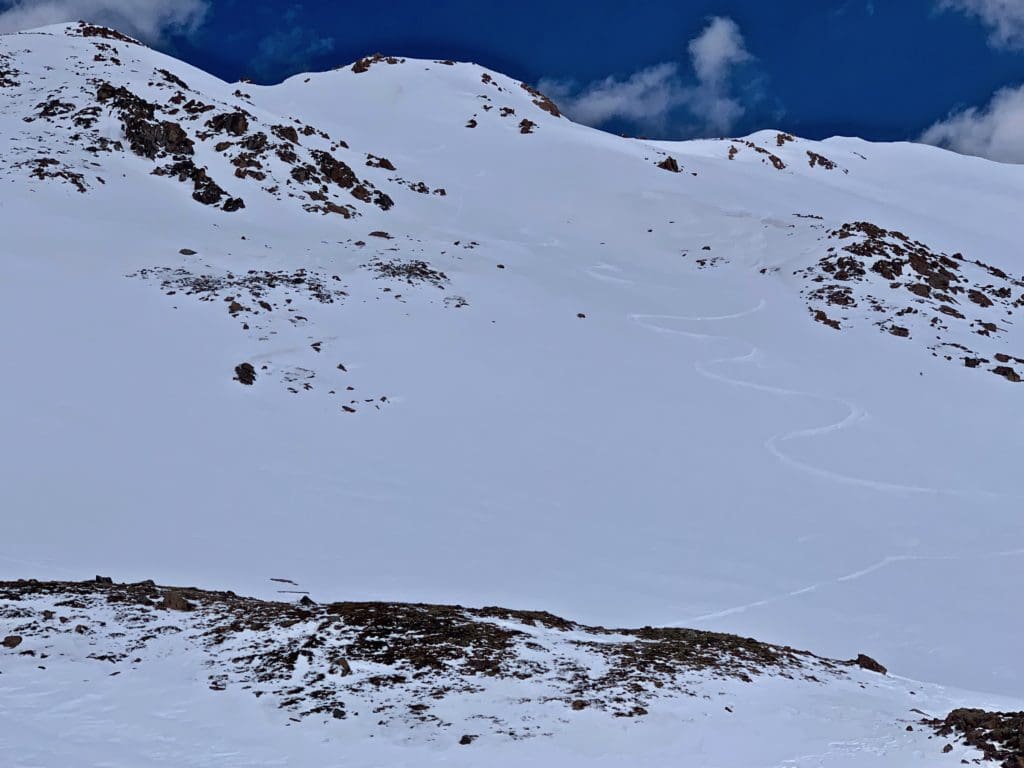
- Good for: Introduction to the area, the possibility to ski from the top of Pt. 13,418 and wider alpine turns with few hazards that are easy to identify.
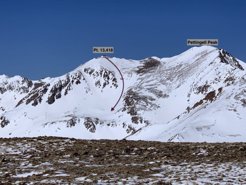
Bow-Leg route potential.
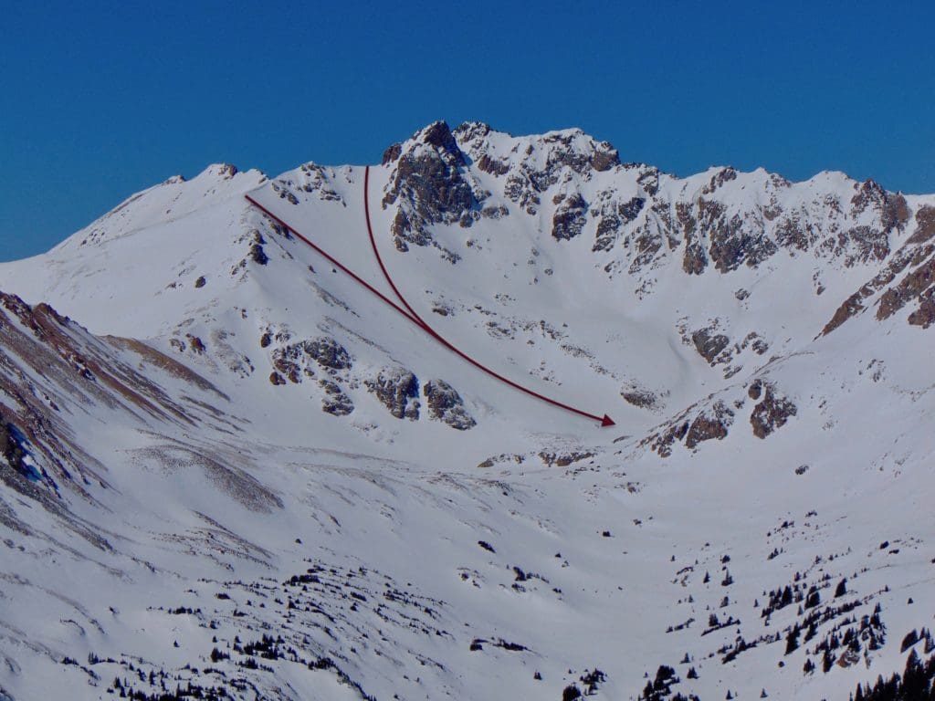
- Pt. 13,418: Couloir Central
Couloir Central is the most difficult of the main options from Pt. 13,418, respect the mountain and respect your risk threshold; this is unforgiving terrain. The easily identifiable couloir starts to the south (climbers left) of the Bow-Leg Line and dives into a steep and aesthetic couloir. There is a cornice to navigate at the top, which gives it an initially steep pitch before moderating slightly. This couloir is skiable into the early summer but shines best in the April-May timeframe. GPS for bottom of ski line (39.72359, -105.90031).
- Essentials: ~0.3 miles, ~750 vertical feet (+400 to Herman Lake AND, if conditions permit, +~230 from top of Pt. 13,418)
- Status: Very Difficult
- Steepest Slope Angle: 45 degrees or more (brief) depending on cornice size and snow loading at the top
- Good for: Big mountain couloir skiing with rock hazards on each side and later in the season. NOT for beginners.
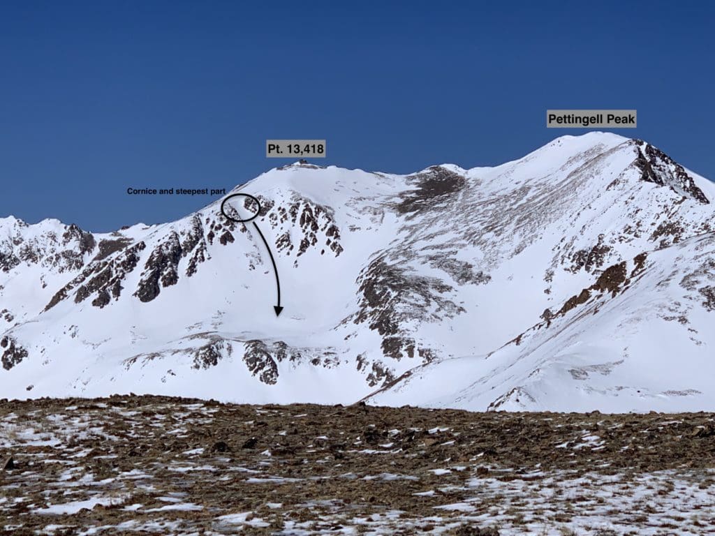
Couloir Central on Pt. 13,418.
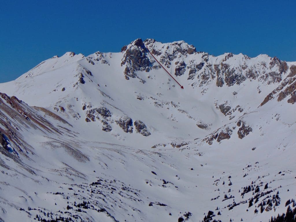
- Pt. 13,418: South Couloir
This aesthetic couloir is interesting for various reasons and can, in good conditions, offer some of the best skiing in Herman Gulch. Like the Couloir Central, this line exudes big mountain energy and should be taken very seriously. For the dedicated and experienced, it can offer a longer descent than the two other lines because you can avoid the flat bench and ski down to the base of Herman Gulch. If coverage is continuous from the top of Pt. 13,418, you can net ~1650 vertical feet. As always, better to climb the couloir first before descending, especially if you’re not entirely sure where the entrance is. GPS point from the bottom of South Couloir (39.71907, -105.89700).
- Essentials: ~0.4 miles, ~1230 vertical feet (if continuous snow from summit to Herman Gulch, ~0.7 miles, ~1650 vertical feet.)
- Status: Difficult
- Steepest Slope Angle: 42 degrees (brief)
- Good for: Big mountain couloir skiing with a longer runout potential than nearby lines. NOT for beginners.
Pt. 13,418: South Couloir.
- The Citadel: Snoopy’s Backside Chute
This is probably the most famous line on the Citadel and a target for many spring skiers. It is steep, aesthetic, and inspiring in the right conditions. If you do this on a low avalanche weekend, there will likely be others on the line, and it is critical that you climb from the bottom to assess the conditions before dropping in. GPS for the bottom of the line (39.71830, -105.90672).
- Essentials: 0.36 miles, ~1,000 vertical feet
- Status: Very Difficult
- Steepest Slope Angle: 45-50 degrees
- Good for: One of the classic Front Range ski descents in a stellar environment with a steep, thin start and a wide GS-friendly bowl at the bottom. ABSOLUTELY NOT FOR BEGINNERS.
Snoopy’s Backside Chute from Mt. Machebeuf.
- Citadel’s East Bowl
The wider and friendlier East Bowl of Citadel is a great alternative to Snoopy’s Backside but comes with its own set of challenges as well. The biggest hazards are a few rocky points along the ridge and a sneaky cornice that rings most of the bowl. You can usually find reprieve if you start your line very close to the Citadels East Summit or far enough down the ridge, as long as you don’t mind a shorter run. Once the cornice is managed, line options abound. GPS for the bottom of the line (39.71703, -105.90672).
- Essentials: 0.3 miles, ~800 vertical feet
- Status: Difficult (Very Difficult if you decide to jump the cornice)
- Steepest Slope Angle: 36 degrees (higher if jumping the cornice)
- Good for: A wide area with plenty of creative line possibility. Watch the cornice as it can be quite extensive. NOT for beginners.
Citadel’s East Bowl.
Dry Gulch
This gully lines the southwest side of Herman and is largely forgotten by the summer hiking crowds due to a lack of trails and clear access. For the dedicated backcountry skier, however, Dry Gulch has a great variety of skiing options that rival the Upper Herman Gulch lines, with typically far fewer (if any) people around.
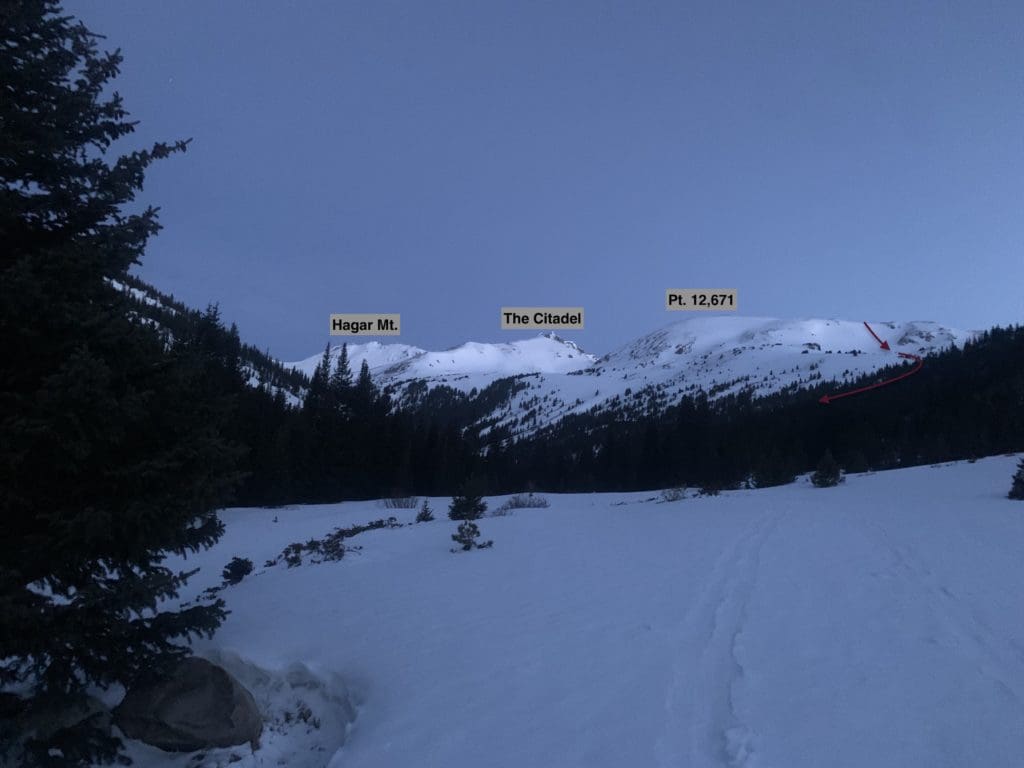
To access Dry Gulch, you can either hike up Herman Gulch and cross the low point of the ridge between Pt. 12671 and the Citadel, or hike up the gulch from the bottom. The latter option is much simpler but requires an additional bit of driving to reach. Use exit 216 off of I-70, following initial signs for Loveland Pass. At the end of the offramp, take a hard right (about 180 degrees) until you see a dirt road paralleling the exit ramp you just came off of. In snowy conditions, park as far as you can without getting stuck. If the road is dry, you can drive to the gate (saves you a few points of a mile) and begin your journey from there. Follow the road into the gulch until it dead ends. Then, head left (northwest) into the gulch.
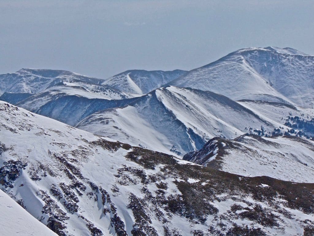
Dry Gulch from Hagar Mt.
- Pt. 12,671 southern slopes
Unnamed and overlooked, Pt. 12,671 nonetheless offers stellar skiing. When this line is skied, it’s usually combined with others in the region. If you’re pressed for time or just want to try something new, consider making this a focus of a half-day outing. The skiing is nice, and the views are superb. Be aware that the southern exposure heats up early on warm spring days but helps the line avoid wind-loading and many of the resulting wind slab avalanche issues. GPS for the bottom of the line (39.70380, -105.88906).
- Essentials: ~0.9 miles, ~1500 vertical feet
- Status: Difficult (the upper part is steep and bumps the rating up, the bottom is more mellow and fits within the moderate distinction)
- Steepest Slope Angle: ~35 degrees for the first 200ish feet.
- Good for: A quick half-day outing when other aspects may be more dangerous. The southern exposure helps consolidate the snowpack faster, although dangers do exist. This line is NOT for beginners.
Southern Slopes of Pt. 12,671 from near the entrance of Dry Gulch.
- The Citadel: Snoopy’s Collar
This line starts at the saddle between the two summits like Snoopys Backside Collar; it just heads down the opposite side. The skiing is aesthetic, consistent and downright delightful. Due to the southern exposure, this line heats up faster on spring days; however, an April-May descent almost guarantees skiing bliss. You definitely want to climb this line before skiing it; there are some basic hazards to identify, including a few rocky areas. GPS point for the bottom of the line (39.70742, -105.91174).
- Essentials: 0.55 miles, ~1100 vertical feet
- Status: Difficult (much steeper up top before opening up into a wider bowl)
- Steepest Slope Angle: 40 degrees
- Good for: Another area classic with aesthetic, big mountain skiing. Rocky hazards exist later in the spring. NOT for beginners.
Snoopy’s Collar from near the head of Dry Gulch.
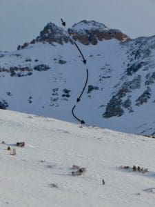
- Hagar Mountain: Boomerang
While Citadel is the dominant skiing mountain in these gulches, Hagar is a close second. The Dry Gulch facing slopes harbor many line varieties and due to their orientation, can be a fantastic place to catch a sunrise. Like the Citadel, this is big mountain skiing and appropriate research and skill are necessary to make the most of what Hagar can offer. The Boomerang is a couloir that starts northeast of Hagar’s summit block and snakes down to a bench where Snoopy’s Collar ends as well. GPS point for the bottom of the line (39.70742, -105.91174).
- Essentials: ~0.5 miles, ~1100 vertical feet
- Status: Very Difficult (this is couloir skiing, so although the slope angle isn’t the steepest around, the demands of couloir skiing elevate the difficulty rating).
- Steepest Slope Angle: 40 degrees
- Good for: Great couloir skiing on a large mountain. Given that it is a fairly defined couloir, you’ll want to be familiar with shorter turn and avalanche hazards. NOT for beginners.
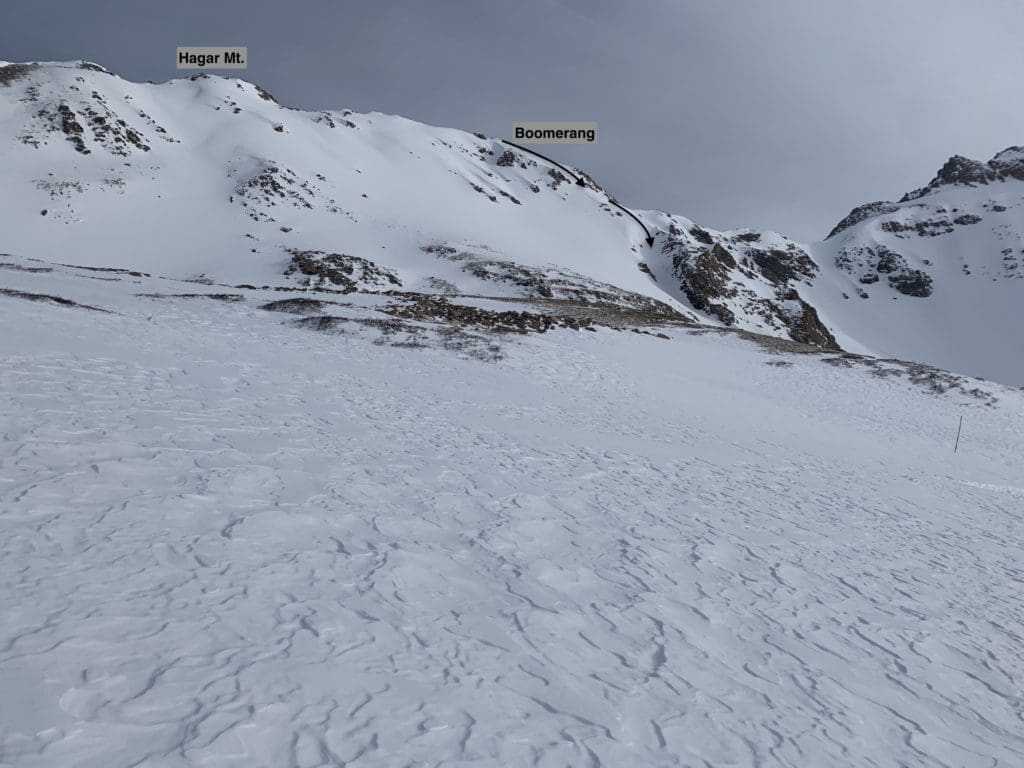
Boomerang ski line seen from Dry Gulch.
- Hagar Mountain: Small Alaska
The snow-saturated Small Alaska face (visible throughout much of Dry Gulch and atop Chet’s Dream Ski Lift at Loveland) is a magnet from afar, and for good reason. The face looks like something plucked from the arctic after a good snowstorm and holds snow well. Like other southerly oriented faces, warm spring days heat up the snow quickly, get there early and after a good freeze to help alleviate wet avalanche concerns. There are multiple ways to ski this face, although the two most logical options are to start from the southern sub-summit or near the actual summit and ski into an obvious gully that descends between the two high points.
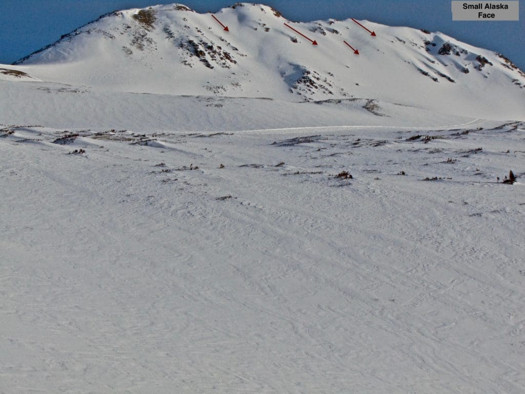
The small Alaska face holds numerous potential ski lines.
- Essentials: 0.55 miles, ~1100 feet (up to nearly 3000 ft. if you connect snow all the way down Dry Gulch)
- Status: Difficult
- Steepest Slope Angle: 38 degrees (brief)
- Good for: Skiing a beautiful mountain with stunning views and consistent snow. Get there early to avoid wet avalanche issues. NOT for beginners.
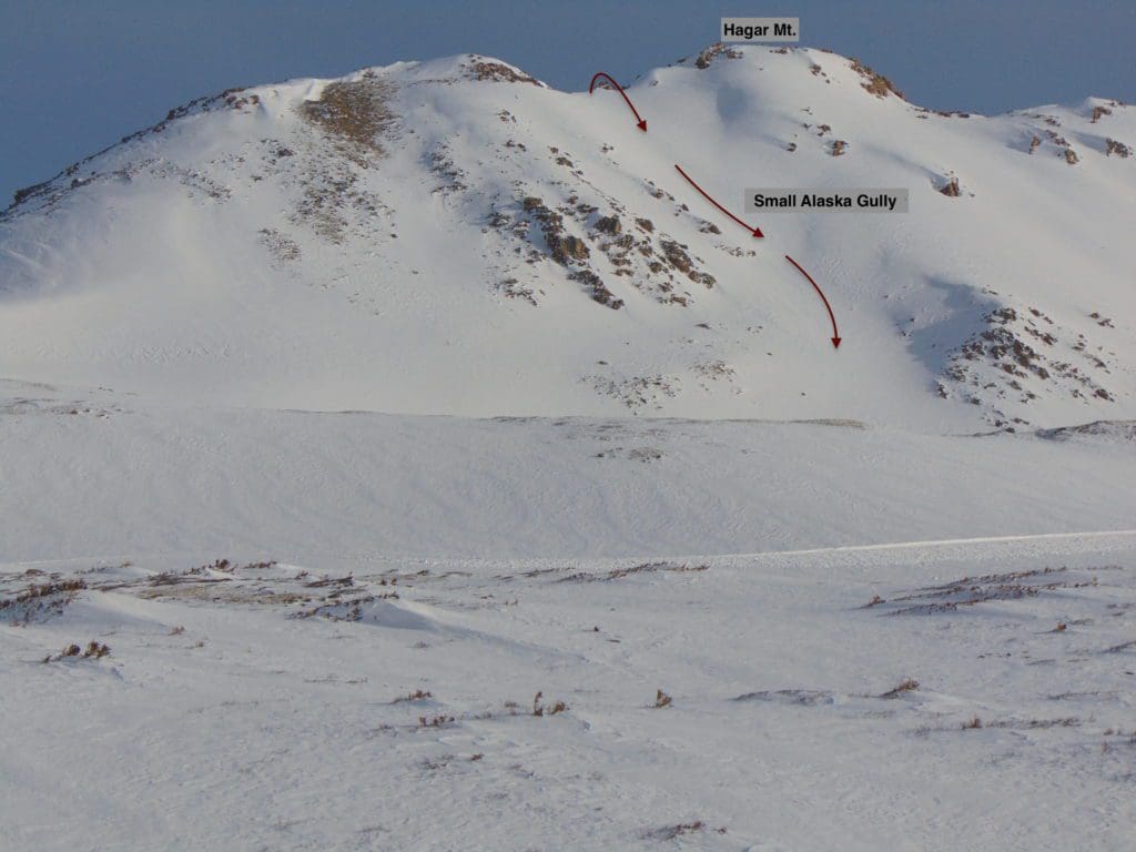
Small Alaska Gully, the most logical descent option.
Maps and Extras
Rounding out the Dry Gulch coverage are Golden Bear and Mt. Trelease. There are solid arguments for including them, and each one features notable alpine ski options and even some quality tree skiing on the lower flanks of Trelease; however, Loveland Ski Resort leases the terrain on and around these mountains. While no fixed lift is in Dry Gulch, and there don’t appear to be any plans to install one, Loveland uses the area for its cat-skiing operations, and it falls under their special use permit from the Forest Service. With that in mind, I’ve decided to omit their inclusion in favor of covering mountains that are all public land and outside ski resort boundaries.
Since this is a fairly complex area with a lot of ski potential, I’ve thrown together a Caltopo map with all lines covered. Use this link to access the map.
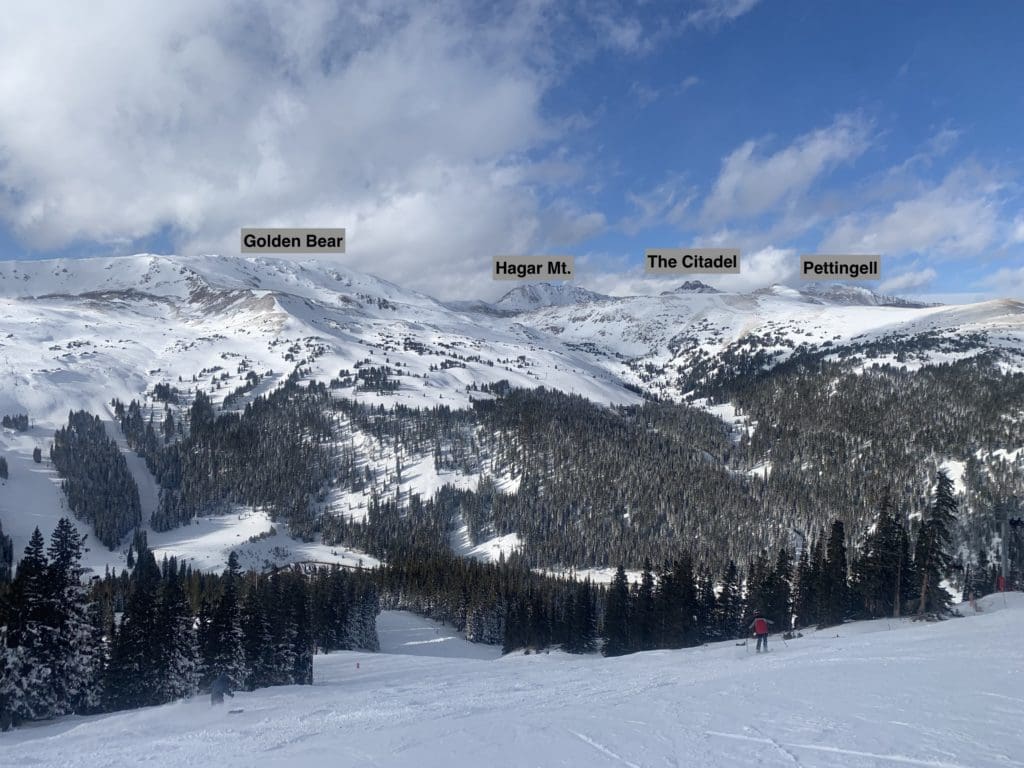
Hagar and the Citadel from Loveland Ski Resort.
Additional Resources
AIARE. (n.d.) Retrieved April, 2022, from https://avtraining.org
CAIC (Colorao Avalanche Information Center). (n.d.) Retrieved April, 2022, from https://www.avalanche.state.co.us/
Front Range Ski Mountaineering. (n.d.). Retrieved April, 2022, from https://www.frontrangeskimo.com/
Gratz, Joel. (2022). Colorado Daily Snow. Opensnow. Retrieved April, 2022, from https://opensnow.com/dailysnow/colorado
Powder Project. (n.d.) Retrieved April, 2022, from https://www.powderproject.com/
Popular Articles:
Backcountry Skiing in Rocky Mountain National Park: Longs Peak Area
Backcountry Skiing in Rocky Mountain National Park: Bear Lake Area
Guide To Backcountry Skiing Near Cameron Pass, Colorado
Guide To Planning A Backcountry Ski Adventure

Skyblue Overland Strongly Recommends That You Enroll With Global Rescue Prior To Embarking On Your Next Adventure.
With more people outside now more than ever, Global Rescue expanded services to include field rescue within 100 miles of home. With Local Field Rescue — automatically included in any travel protection services membership — Global Rescue is there whether you’re hiking, kayaking, snowmobiling, fishing or simply enjoying the outdoors and get ill or injured and you’re unable to get to safety on your own. Purchase a Global Rescue membership for your next adventure and travel with peace of mind. Single trip, annual and family options are available.
Terms of Use: As with each guide published on SKYBLUEOVERLAND.com, should you choose to go backcountry skiing, do so at your own risk. Prior to setting out check current local weather, conditions, and land/road closures. While taking a trail, obey all public and private land use restrictions and rules, carry proper safety and navigational equipment, and of course, follow the #leavenotrace guidelines. The information found herein is simply a planning resource to be used as a point of inspiration in conjunction with your own due-diligence. In spite of the fact that this guide was prepared under diligent research by the specified contributor and/or contributors, the accuracy of such and judgement of the author is not guaranteed. SKYBLUE OVERLAND LLC, its partners, associates, and contributors are in no way liable for personal injury, damage to personal property, or any other such situation that might happen to individuals following this guide.


