


|
Getting your Trinity Audio player ready...
|
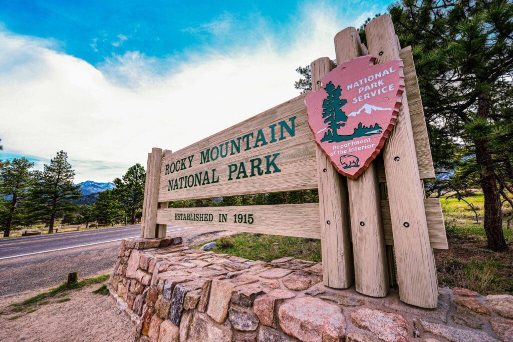
Established in 1915
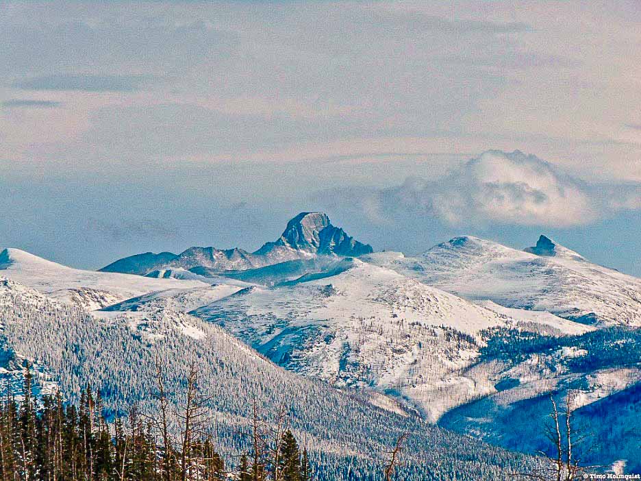
Rocky Mountain National Park: a wonderland of mountains, wildlife, and adventure. Explore 415 sq miles on 300+ mi trails or drive the highest paved road in the US. You’ll see shimmering lakes, lush forests, icy glaciers, tundra and a wide variety of wildlife.

Overview:
Nestled within the Rocky Mountains lies a stunningly beautiful national park, boasting breathtaking vistas, varied wildlife, and endless opportunities for outdoor adventures. Whether you prefer trekking through nature’s paths, casting your fishing line into tranquil waters, or simply basking in the splendor of the scenery, this park has something to offer for everyone.
With over 300 miles of trails spanning 415 square miles, as well as the picturesque Trail Ridge Road – known as the highest paved road in the nation – there are countless ways to explore this natural wonderland. Keep an eye out for elk, bighorn sheep, moose, and other animals as you journey through colorful wildflower fields and witness the changing foliage throughout the seasons. Rocky Mountain National Park is open year-round and promises unforgettable experiences and cherished memories for all who visit.
It takes a little while, beyond numerous pullouts and scenic valley views, before Trail Ridge really starts climbing. Once it does, however, you’ll be hard-pressed to look away. Ascending to an elevation over 12,000 feet, the road not only bisects Rocky Mountain National Park (RMNP) but gives a scintillating preview of what this quarter-million-acre slice of mountain majesty provides.
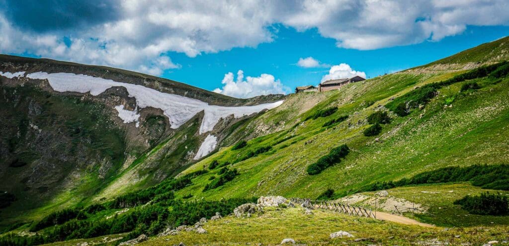
Trail Ridge is undoubtedly one of the highlights of the park, and how could it not be? The road, completed in 1932 and offering over 11 miles of above-treeline views, is a gem. It’s also the highest continuously paved road in North America. If you’re new to the Rocky Mountains, this is the best way to get excited about the park.
However, Rocky Mountain is a hiker’s paradise with over 400 named destinations to visit; Trail Ridge only scratches the surface.
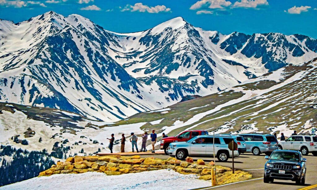
Visitors observe the peaks from Trail Ridge Road in Rocky Mountain National Park, Colorado
Table of Contents
Article Navigation: Click on any of the listed items in the table of contents below to jump to that section of the article. Similarly, clicking on any large, white section header will jump you back to the Table of Contents.
- Overview
- Important Details
- Human History
- Natural History
- Geography
- Fauna
- Wildflowers
- Winter Weather
- Summer Weather
- Best Places to Stay
- Adventures by Region
- Guided Trips
- Conclusion
Important Details
Rocky Mountain national park has a permit and fee system from late spring through mid-autumn. Please visit the links below to get the right passes. The park service is limiting the number of people per day, so it’s very important that you do this before you arrive!
Broken down, you need two items: an entrance pass and a timed entry slot. If you arrive at Bear Lake Road BEFORE 5 am, you don’t need a timed entry, but you always need an entrance pass. If you arrive at other areas of the park before 9 am, you don’t need a timed entry, but again, you always need an entrance pass to enter the park.
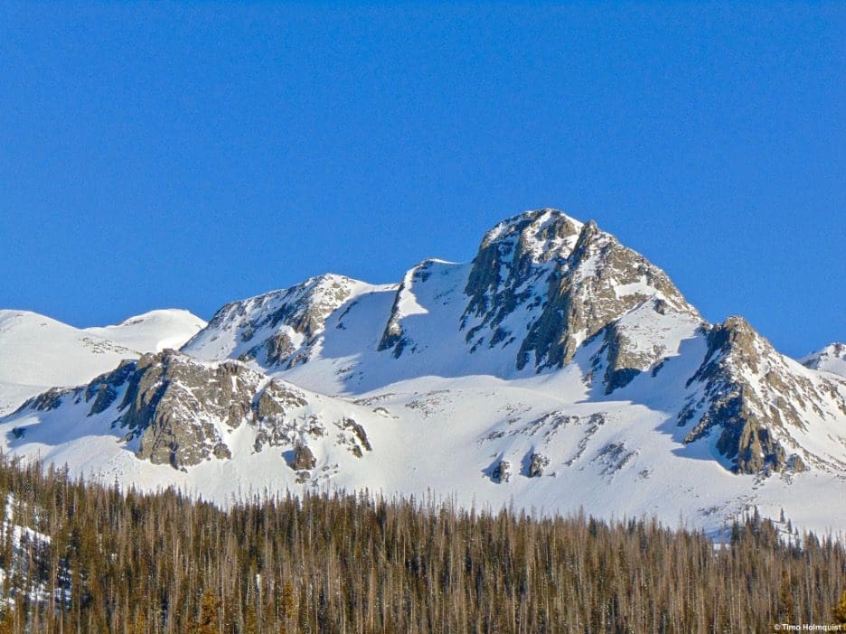
One of many beautiful mountains waiting for you in Rocky Mountain National Park.
Human History
Rocky Mountain National Park was established in 1915 after a decades-long effort to get the area recognized for its scenic beauty. Most of that effort came from people like Enos Mills, a naturalist, nature guide, and lodge owner. Through dogged perseverance, the park was created. Intrepid explorers will find many examples of park features honoring the work of Mills, including Mills Lake in the otherworldly Glacier Gorge region.
Before the creation of the park, homesteaders and loggers had been using the area. Remnants of old logging camps, like Lulu City on the western fringes of the park, offer reminders of the area’s wild past.
Before settlers ventured into the area in the 1860s, the region was dominated by the Ute Native Americans. Due to the rugged terrain and imposing mountains, they preferred the verdant green valleys on either side of the main line of mountains making up the middle of the park. Kawuneeche Valley, the Beaver River Meadows, and Fall River Meadows were areas commonly used by Native Americans to hunt.
Rocky Mountain National Park Entrance at Beaver Meadows near Estes Park, Colorado.
Looking For An Amazing Adventure? Book A Guided Hiking, Rock Climbing or Backcountry Skiing Adventure in Rocky Mountain National Park.
Natural History
The Rocky Mountains formed through a series of building events called orogenies. Three main ones impacted the formation of the range. The most pertinent to Rocky Mountain National Park (and many areas of Colorado) was the Laramide Orogeny.
During the Cretaceous Period (i.e., the time of the T-Rex), this orogeny created much of the topography of the park. It didn’t occur all at once but rather over millions of years. The resulting change was a combination of big mountain blocks and high-elevation basins.
After the dinosaurs died out, various episodes of natural history occurred within the park. The one that’s mentioned most often because of its visible scars on the land is the Ice Age. During this time, massive glaciers formed and advanced all over the park. Evidence of this is plentiful, especially in the U-shaped valleys of Glacier Gorge.
Post Ice Age, the glaciers retreated, and many disappeared. However, remnants remain, some with enough mass to move under their own weight, which means they are still active glaciers. The most accessible are Andrews Glacier, Taylor Glacier, Tyndall Glacier, and Rowe Glacier. Compared to the Columbia Ice Fields in Canada, these remnants are small and often mistaken simply for snowfields; however, they are beautiful features worth visiting (and sometimes recreating on).
After the main glaciers retreated, they left rocky valleys and dramatic cliffs, many of which are visible from Estes Park, the main gateway town on the eastern side of the park.
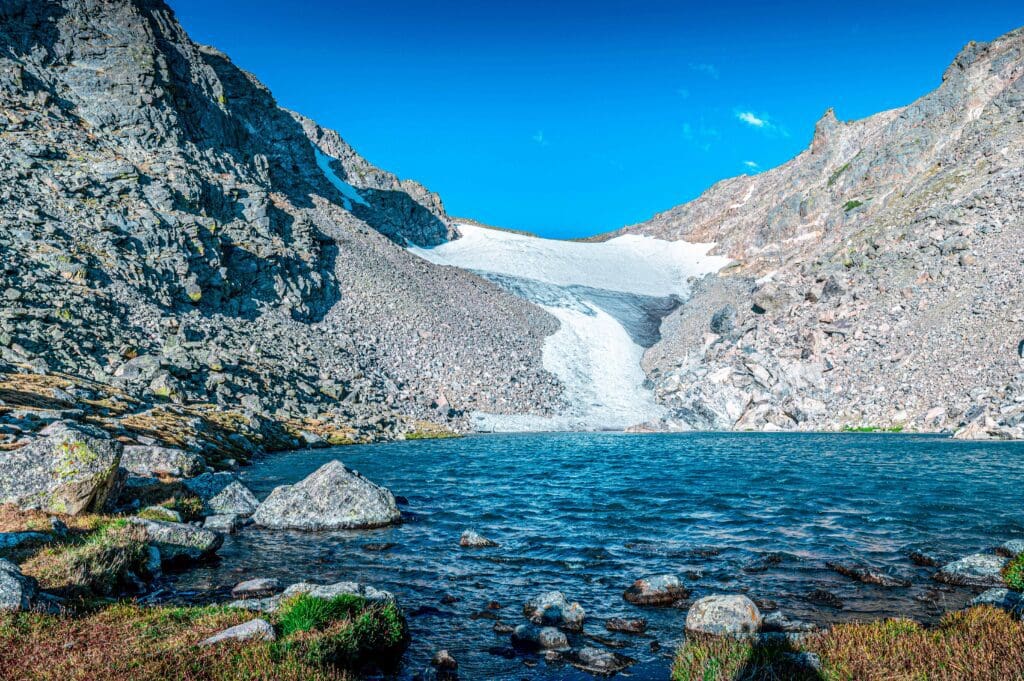
Andrews Tarn and Andrews Glacier in Rocky Mountain National Park, Colorado. Photo by David Spates.
Geography
Rocky Mountain National Park can be divided into several geographic regions. The backbone of the park is a north-south running ridge called the Continental Divide. The divide is an unbroken chain of highlands that separates watersheds. Rain that falls on the eastern side eventually flows into the Atlantic Ocean, while rain falling on the western side eventually flows into the Pacific Ocean.
The Continental Divide forms a natural wall through the park and contains some of Rocky’s most dramatic features, but other mountain bubbles spur off from the main divide. The most dramatic of these is the Longs Peak/Mount Meeker massif. Longs Peak is the highest in the park at 14,259 feet and the farthest north 14,000-foot mountain in the Rocky Mountains.
In between these mountain clusters lie a few valleys and “parks.” A park is a high, flattish mountain basin. Estes Park, the most likely entrance point to the park, sits in an example of one. Beaver Meadows and Fall River are similar, along with the very remote 10-lake park. On the western side of Rocky, the Kawuneeche Valley sits supreme.
A herd of elk in the Kawuneeche Valley on the west side of Rocky Mountain National Park in Colorado. This is a marshy valley near the headwaters of the Colorado River in the Never Summer Mountains.
It’s not just the mountains and valleys that make the park special. The Never Summer Mountains, on the western side of the park, are home to the headwaters of the mighty Colorado River. Already a sizable mountain stream by the time it leaves the park, the river goes on to flow all the way into the Gulf of California, providing water for over 40 million people along the way.
There are also tons of lakes that dot the backcountry areas of the park, providing countless iconic vistas from which to admire the natural splendor of the Rocky Mountains. Elevations in the park range from just under 8,000 to 14,259 feet. With ~6,400 vertical feet of variance, Rocky Mountain National Park features a rich tapestry of ecological landscapes and zones!
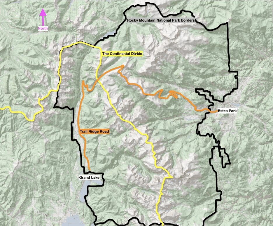
RMNP borders, with the Continental Divide and Trail Ridge Road drawn in. The two gateway towns, Estes Park in the east, and Grand Lake in the west, are also shown.
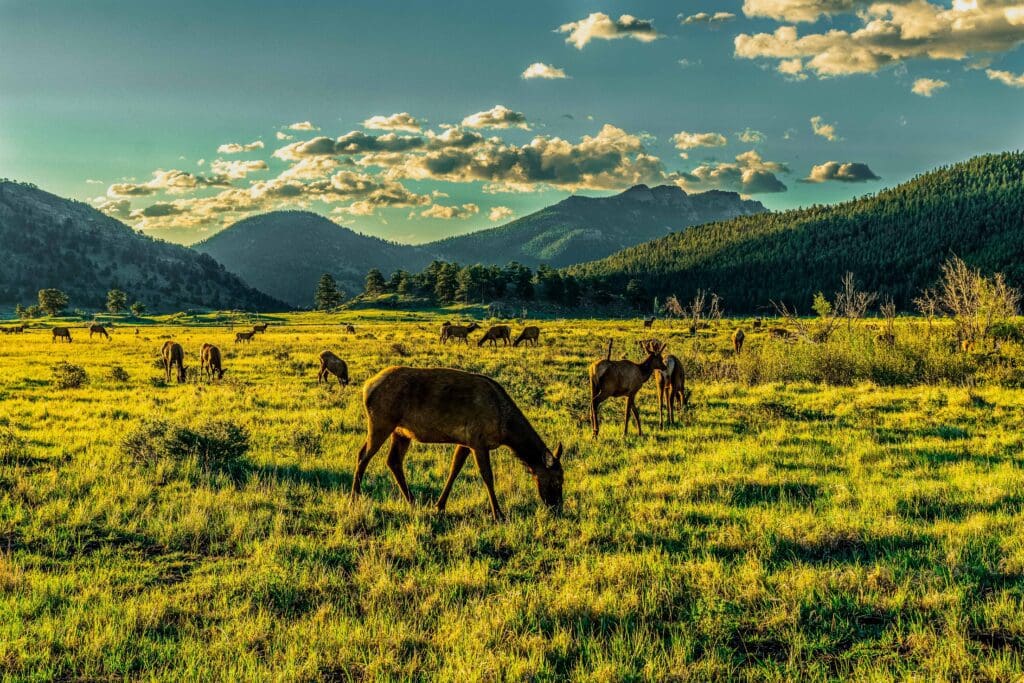
Fauna
One of the joys of visiting Rocky is getting to see some of the animals that call the park home. There are over 70 species! Here’s a simple list of some (not all) that you may find. If you spot one while driving, PLEASE don’t stop in the middle of the road. There are plenty of pull-offs you can use. And do not approach large wildlife! Moose, elk, and bighorn sheep have all been known to charge when they feel threatened.
- Moose
- Elk
- Deer
- Bighorn Sheeps
- Black Bears
- Coyotes
- Bobcats
- Lynx
- Mountain Lions
- Snowshoe Hares
- Ptarmigans
- Pikas
- Marmots
- Squirrels
- Chipmunks
- Fish (Brown, Brook, Rainbow, and Cutthroat Trout)
- Seasonal Raptors (Hawks, Falcons, eagles)
- Foxes
A Coyote near Sundance Mountain.
Wildflowers
From June through July, Rocky Mountain National Park plays host to a fantastic display of wildflowers. Please don’t pick the flowers; that kills them. Here’s a list of what you can find, courtesy of the national park service.
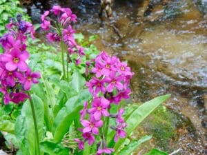
Parry Primrose in Rocky Mountain National Park.
Winter Weather (Nov-April/May)
Rocky Mountain National Park experiences its fair share of wild weather. Snow can fall on top of Longs Peak any month of the year. However, that doesn’t mean you can’t find snow-free hikes in the park. Snowfall in this region follows a general west-to-east trend, with north-south variations. What that means is that the western side of the park and the crest of the Continental Divide often see the highest snowfall numbers.
Snow can and does fall in Estes Park, but it’s not uncommon for it to melt between storms, given a few days of sunshine. Having said that, if the eastern side of the park is in the crosshairs of an Upslope Storm, where the weather flips with precipitation coming in from the east, Estes can get feet of snow.
Logistically, the biggest difference between summer and winter is the closing of certain roads. Fall River and the Wild Basin Road close with the first snowfall, and Trail Ridge shuts down from roughly November to the last week of May. So, while you can still get into either side of the park in the winter, you can’t cross between them.
Longs Peak, seen from the western side of the National Park in the Never Summer Mountains.
Trail Ridge is plowed up to Hidden Valley on the eastern side, meaning you can still see Fall River, Beaver Meadows, Deer Mountain, and the Hidden Valley area (home to the park’s only sledding zone). Long Peak Road and Bear Lake Road are also plowed, with higher priority slotted to Bear Lake.
Likely the busiest corridor in the park, Bear Lake Road provides access to iconic areas like Glacier Gorge, Dream and Emerald Lake, Lake Haiyaha, and Flattop Mountain. On the western side, US34 is open to the Colorado River Trailhead. The hikes here are longer and tougher to get to but provide a solitude-first experience unlike any offered on the eastern side.
Keep in mind that while certain roads are plowed through the winter, if several inches of snow fell the night prior to your visit, expect lengthy delays until crews can safely plow the roads.
Park visitation usually rises in April and May. Weekends here may lull visitors into a false sense of spring because Estes may be snow-free and in the 60s. Don’t be fooled. There’s snow from about 8,800 feet and above through May. Above-average snow years push that through mid-June. If you want to hike in the spring near or above treeline, bring snowshoes and traction devices!
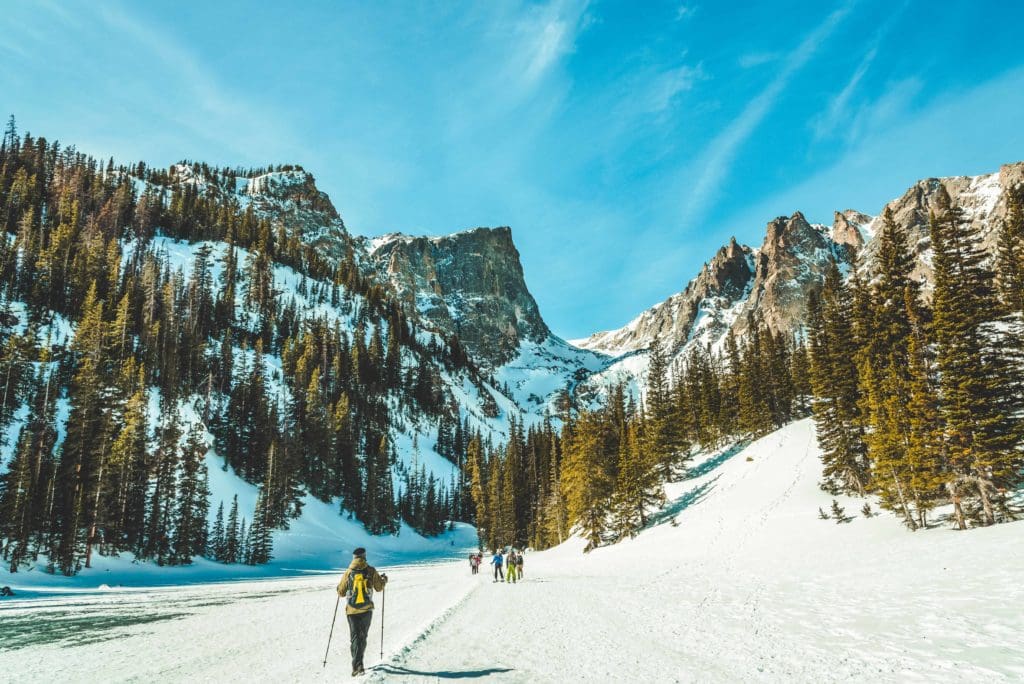
Crossing the frozen surface of Dream Lake, Rocky Mountain National Park, Colorado.
Summer Weather (June-October)
The most popular time to visit Rocky is in the summer. The weather settles, and Trail Ridge opens back up. However, weekends can be absolutely inundated with people. To minimize crowds, the park has instituted a fees and pass system. Make sure you know what you need BEFORE you get to the park!
June is a great month to visit the eastern side of the park, as it is usually snow-free. The area around Estes Park is drier than the western side. However, alpine areas will still have large connected snow patches.
There are two main concerns in Rocky in the summer. The first, and likely most relevant, are afternoon thunderstorms. This region of Colorado is impacted by the NAM (North American Monsoon). Monsoonal rains get pumped northwards through the desert southwest and into Colorado. Sometimes, these plumes of moisture are strong enough to make it to Northern Colorado. The general rule of thumb is to be off of any summit or alpine area by around noon if there’s a chance for thunderstorms. Storms form quickly and can produce damaging hail, lightning, and wind.
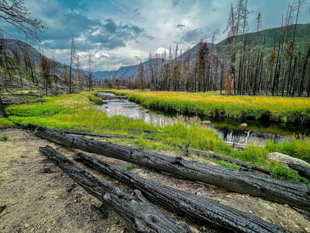
The East Troublesome Fire began on October 14, 2020 in Grand County. A week later, high winds turned it into a 100,000-acre inferno racing northeast into Rocky Mountain National Park. In the photo above taken in September 2021, shows the landscape nearly a year after the East Troublesome Fire roared into the North Inlet Valley in RMNP.
The dry season in August and September brings another danger: wildfires. While not a yearly occurrence, they have impacted the park before. Most recently, the duel threat of the Cameron Peak Fire and the east Troubleoms Fire scorched thousands of acres in the park. ALWAYS HEED FIRE BANS, and note that outside of managed campgrounds, NO CAMPFIRES ARE ALLOWED IN THE BACKCOUNTRY. During this time of year, dry, windy fronts make the area a tinderbox ripe for burning.

Moomaw Glacier from Eagles Beak in the remote and rugged Wild Basin.
Best Places to Stay
Hotels and Lodges
About 80% of National Park visitor traffic funnels through Estes Park, making it the logical place to stay if you’re visiting. The town is a 4-season playground, although it offers a much quieter experience in the winter. You can stay at numerous Airbnbs, motels, and hotels, like the historic (and haunted) Stanley Hotel.
On the other side of the park, the adventure town of Grand Lake awaits. Grand Lake has several accommodations, nearby campgrounds, and the iconic Grand Lake Lodge.
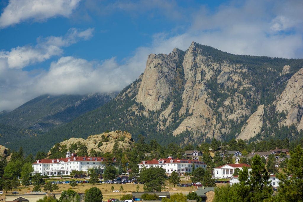
The historic Stanley Hotel in Estes Park, Colorado.
Camping
Camping near Rocky Mountain National Park will cost you. The options for free area camping are limited. On a positive note, there are plenty of options, and the National Park is within driving distance of Fort Collins, Boulder, and Denver.
- Estes Park: Known as the gateway to Rocky Mountain National Park, Estes sees nearly 80% of park traffic as opposed to the much quieter western entrance near Grand Lake. The town has a ton of lodging options.
- Allenspark: A small town near Wild Basin that has a few lodging options, including the Wild Basin Lodgeand the Sunshine Mountain Lodge and Cabins.
- Rocky Mountain National Park Camping
- Moraine Park Campground: $30 per site. $20 in winter. Established campground with perks, facilities, campfire grate, wood for sale in summer, and bear boxes to store food. Only loop B is open in the winter, and it’s first-come, first-serve.
- For summer, a reservation is needed quite a ways in advance to secure a spot.
- Glacier Basin Campground: $30 per site. Established campground with the same perks as Moraine Park. Reservation required.
- Backcountry Campsites: Rocky Mountain National Park has backcountry sites that you can book in advance. Technical orienteering options are possible but you have to move camp every night. Here are the rules.
- Camping near Estes Park
- Estes Park Campground at Mary’s Lake: Established campground, pricey $45-55. Good backup if other campgrounds are full.
- Hermit Park Open Space: $30 for a tent site, price increases if towing a trailer or for group spots.
- Estes Park Koa: Rates dependent on what you’re bringing with you but will run more than $50 a night in the busy season.
- Olive Ridge Campground in Roosevelt National Forest is the closest campground to the Lookout Mt. trail. ~$20 for a standard non-electric site.
- Free or close to free: but a little farther (if you’re willing to drive)
- Ceran St. Vrain Trail Dispersed Camping ($1)
- County Road 47. Users have reported trash and ATV noise at this location, but it is free.
- Meeker Park Overflow Campground
Rocky Mountain Main Attractions
There are enough features in the park to write numerous book-length volumes. Below, I’ve broken down some of the most popular ones to give you a taste of what the park offers. See if you can find the features on the maps below!
- Trail Ridge Road
- Bear Lake
- Dream Lake and Emerald Lake
- Lake Haiyaha
- The Loch
- Sky Pond
- Black Lake
- Lake Nokoni and Nanita
- Longs Peak (the Boulder Field)
- Thunder Lake
- Bluebird Lake
- Ida
- Flattop Mt.
- Chasm Lake
- Gem Lake
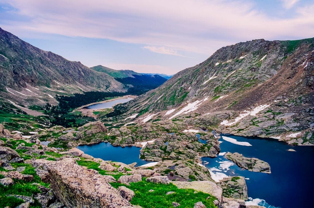
- Spectacle Lake
- Odessa Lake
- Andrews Glacier
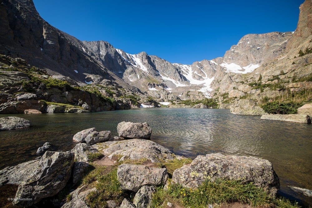
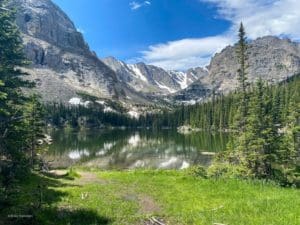
Often called the prettiest lake in Rocky Mountain National Park, Sky Pond is an excellent destination in a beautiful part of the Rockies. Photo by Brian Hamilton.
Adventures By Region
First and foremost, Rocky is a hiker’s park. While Bear Lake Road and Trail Ridge give you a great preview of things to see, you need to hit the trails to get to most of them. More than other parks, Rocky is best for those with an adventurer’s heart and a lot of stamina. Below, I’ve broken down the park by region and detailed the adventures within them.
I’ve also included adventure picks. These are difficult, often off-trail destinations that require a competent outdoors person to tackle. They are listed because the sense of adventure is high, but you need to have prior experience in off-trail navigation, scrambling, and intensive hiking. Always have a plan and tell people where you’re going!
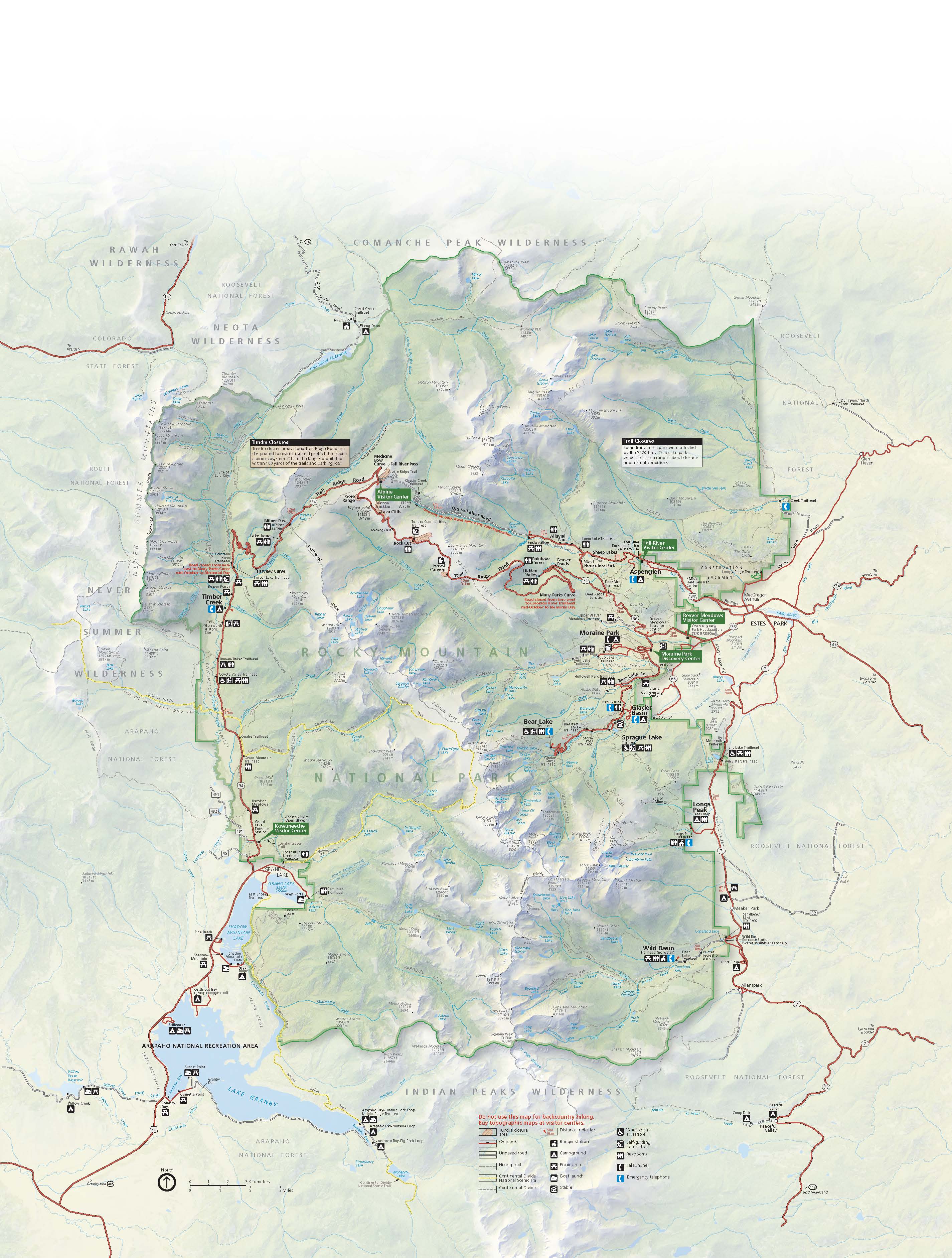
Here is the official Rocky Mountain National Park Official Map. I’ll also include additional maps with labels below for your convenience. Using a combination of them will give you a better sense of where all of these adventures are. All maps in the article are oriented correctly, i.e., up=north, down=south, left=west, right=east.
View of the dramatic glacier carved landscape on the hiking trail to Lake of Glass and Sky Pond in Rocky Mountain National Park, Colorado.
If you’d rather search adventures by activity, visit our companion articles below:
- Best Waterfalls in RMNP
- Best Hiking Trails in RMNP
- Best Alpine Scrambles in RMNP
- Best Lakes in RMNP
- 5 Excellent Backpacking Routes in RMNP
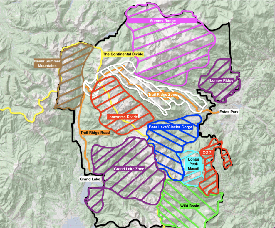
This map has all the various regions drawn in. It doesn’t cover every region but tries to compile the best adventure locations with minimal fire damage. Areas not covered are either in deep wilderness far from any trails or sustained a lot of fire damage from 2020.
Wild Basin
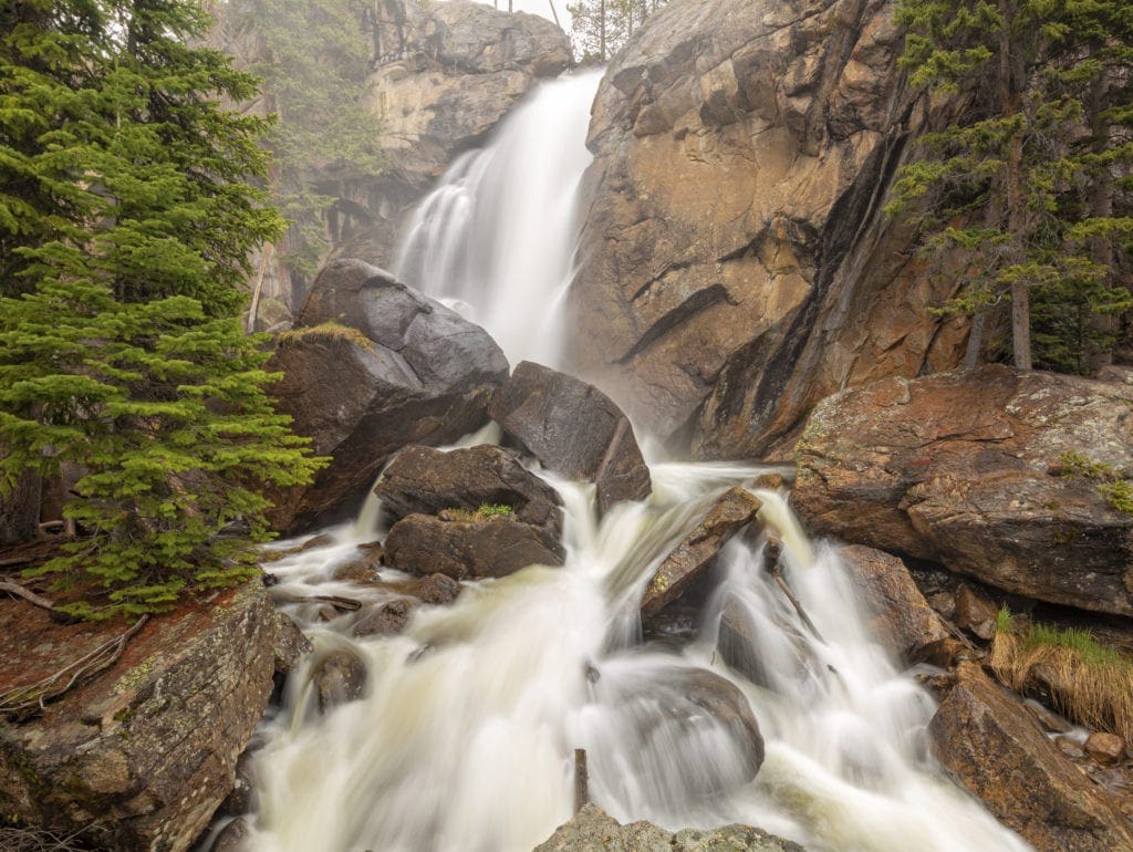
Mist and spray come off Ouzel Falls during high Spring runoff in the Wild Basin area of Rocky Mountain National Park, Allenspark, Colorado.
This enormous basin is one of the crown jewels of the park’s eastern side. Like Glacier Gorge and Longs Peak, it doesn’t surrender its treasurers easily. You’ll be working to get to most of them. In fact, it’s important to note that unless you only plan to see Copeland Falls, Ouzel Falls, and Sandbeach Lake, you’ll be spending more than 10 miles on trails per adventure.
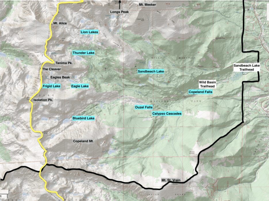
Map of Wild Basin. Yellow Line=Continental Divide. Black Line=National Park Boundary
(Wild Basin. Yellow Line=Continental Divide. Black Line=National Park Boundary)
- Highlights: Beautiful alpine areas, big mountains lakes, stunning mountain vistas, wildflowers, waterfalls, ridge scrambles
- Winter: Snowshoe to Sandbeach Lake (the regular trailhead closes down, Sandbeach is still open, however.)
- Summer: Bluebird Lake, Lion Lakes, Thunder Lake, Mt. Alice, Lake of Many Winds, Mt. St. Vrain, Copeland Falls, Calypso Cascades, Ouzel Falls
- Adventure picks: Mt. Alice via Hourglass Ridge, Tanima and the Cleaver, Eagles Beak
Longs Peak Massif
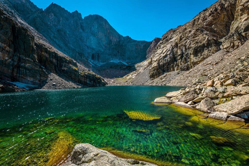
A wide-angle summer afternoon view of Chasm Lake at base of Longs peak, Rocky Mountain National Park, Colorado.
This concentrated area lies on the flanks of the largest mountain in the park. Adventures here are well-documented but can be quite serious. In fact, the easiest way up Longs Peak is a Class 3 scramble. The class rating follows the Yosemite Decimal System, and Class 3 means you’re using all fours to ascend. Dramatic vistas come standard here, especially around Chasm Lake. Think critically about your ability level before attempting a route above what you can handle.
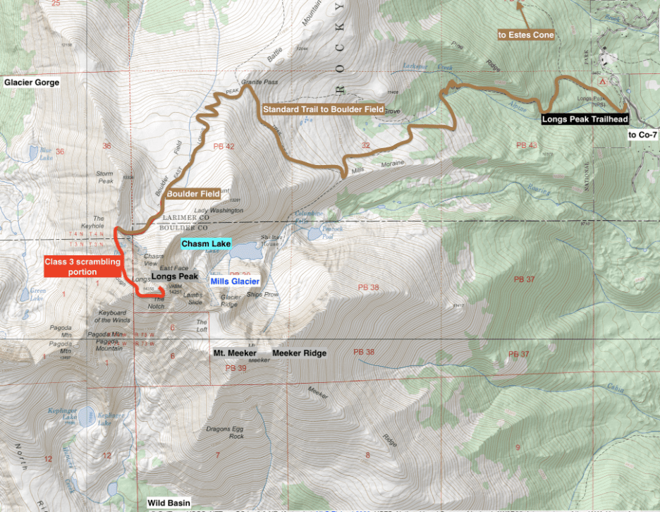
Longs Peak area map.
- Highlights: Enormous mountains, big views, scrambling, streams, and lakes
- Winter: Snowshoeing or cross-country skiing to Chasm Lake, backcountry skiing-Longs Peak Area
- Summer: Boulder Field, Longs Peak via Keyhole, Chasm Lake, Estes Cone, Mills Glacier
- Adventure Picks: Longs Peak via the Keyhole, Mt. Meeker via the Loft, Meeker Ridge
Co-7
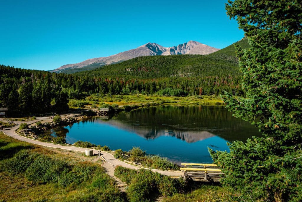
Longs Peak and Mount Meeker reflect off Lily Lake in the early September morning sunshine within Rocky Mountain National Park, Colorado.
This is a strange, linear area north of Wild Basin and just east of the Longs Peak Massif. It’s often overlooked and can provide a quick jaunt into the Park without the commitment of other areas. Having said that, many options exist to turn small hikes into bigger adventures. Plan accordingly.
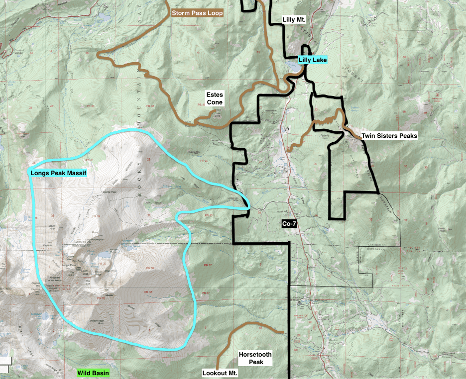
The Colorado 7 section of the park.
- Highlights: Easy access, lakes, views, longer stretches of tree cover (helps in the event of T-storms), streams, scrambling
- Winter: Snowshoe Lily Lake
- Summer: Estes Cone, Lily Lake, Lily Mountain, Storm Pass Loop, Twin Sisters
- Adventure Picks: Lookout Mountain and Horestooth Peak
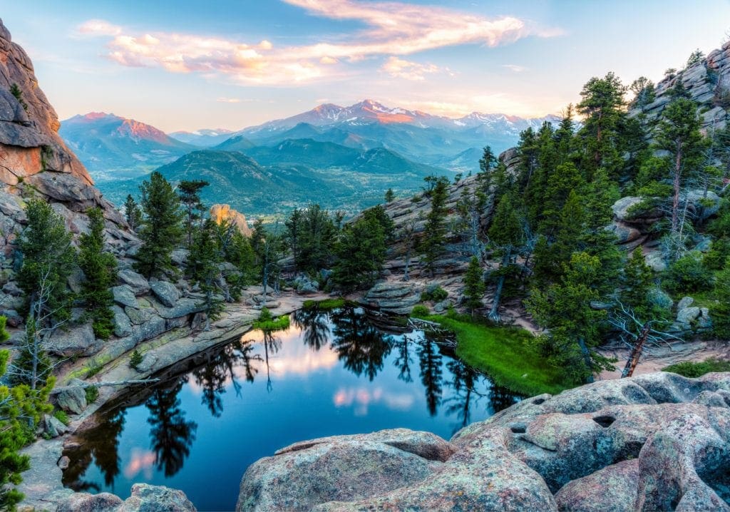
Bear Lake Corridor/Glacier Gorge
Great head-on view of Loch Vale. Thatchtop Mountain to the left, Powell Peak behind. Photo by Brian Hamilton
Likely the most popular part of the park, this concentrated area provides years’ worth of adventure. While many areas are easy to reach, there are several no-joke scrambles and adventures tucked in here that’ll have you whistling under your breath.
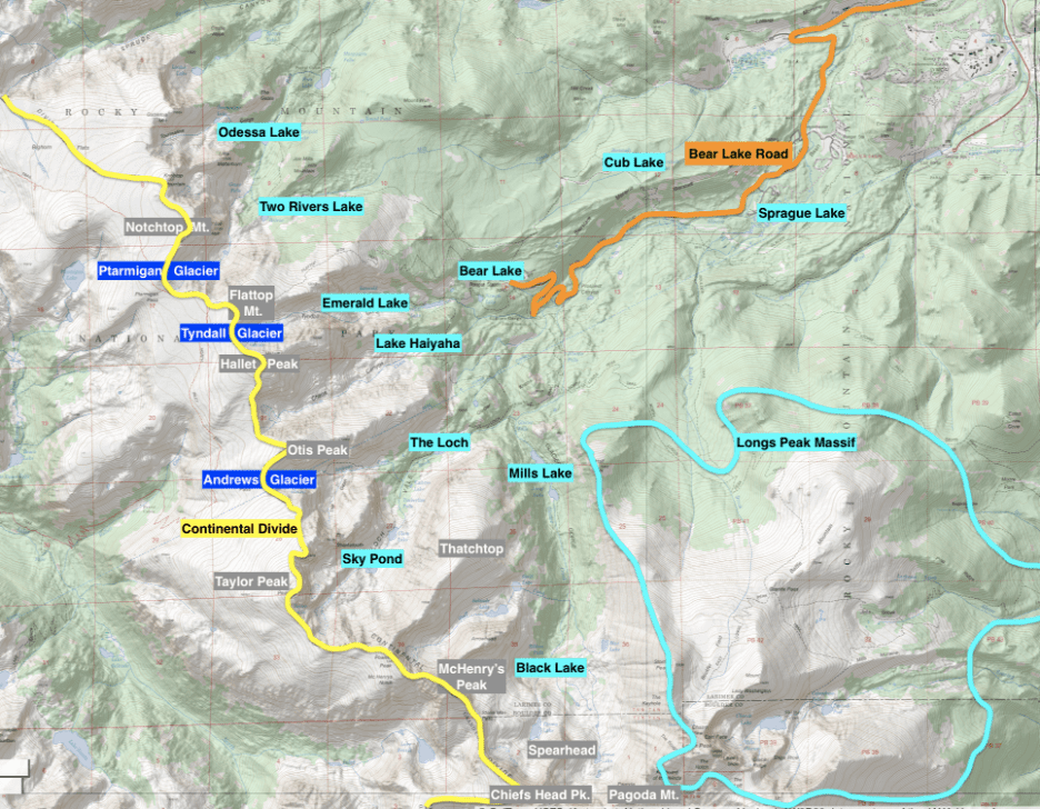
Bear Lake and Glacier Gorge Region.)
- Highlights: National Park-worthy views, alpine lakes, craggy summits, lakes, streams, flora, and fauna
- Winter: Snowshoeing to Emerald Lake, backcountry skiing Bear Lake region
- Summer: Mills Lake, Bear Lake, Emerald Lake, Dream Lake, Lake Haiyaha, Flattop Mountain, Odessa Lake, Black Lake, The Loch, Sky Pond, Andrews Glacier
- Adventure Picks: McHenry’s Peak, the Spearhead, Hallett Peaks East Ridge, Little Matterhorn
Eastern Trail Ridge (to the Alpine Visitor Center)
Old Fall River Road at the Peak of Rocky Mountain National Park, Colorado.
Trail Ridge Road is the perfect introductory area for Rocky Visitors. If you can swing it, get a full day, traverse the road leisurely from east to west, check out the Grand Lake Lodge on the other side (just beyond the western gate), and hang out by the lakes. Then, come back the next day, stopping at all the places you may have missed. If you’re limited by time and a willingness to drive that far (understandable), a logical turnaround point would be the Alpine Visitor Center.
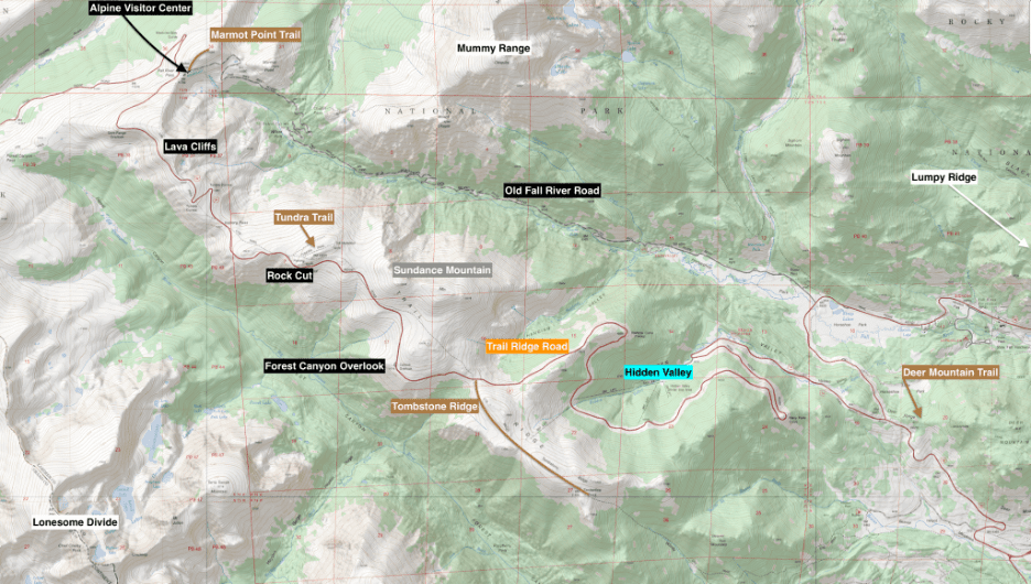
The Trail Ridge Zone.
- Highlights: Dozens of viewpoints and trails off of the highest continuously paved road in America, incredible alpine scenery, chances to see elk, marmots, and bighorn
- Winter: The road closes at Many Parks Curve (east side) and Colorado River Trailhead (west side). However, you can cross-country ski the alpine portion from each trailhead as long as there’s enough snow. You can also access Hidden Valley backcountry skiing or sledding. Deer Mountain is accessible in the winter as well.
- Summer: Tombstone Ridge (Ute Trail), Forest Canyon Overlook, Rock Cut & Tundra Communities Trail (Toll Memorial), Lava Cliffs, Gore Range Overlook, Alpine Visitor Center (another section of the Ute Trail or Marmot Point Trail).
Lumpy Ridge
The last evening sunshine hits Longs Peak and The Crags above Gem Lake in Rocky Mountain National Park, Estes Park, Colorado
Lumpy Ridge is a lumpy ridge just north of Estes Park. The ridge is partially tree covered, with several granite domes poking through the trees. Scrambling and rock climbing routes abound, along with a couple of great introductory area adventures. You’ll use either the Lumpy Ridge Trailhead or Cow Creek Trailhead, which means you won’t enter the park through either of the two main entrances near Estes. This relative isolation can be a blessing on crowded days, although Gem Lake is pretty popular.
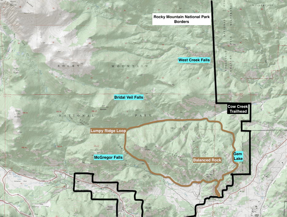
Estes Park is just to the south of this area, and the Mummy Range is to the northwest. You can see a bit of the higher terrain creeping in by the upper lefthand corner.
- Highlights: Different areas of the park, often overlooked, wildflowers
- Winter: snowshoeing to Gem Lake
- Summer: Gem Lake, Bridal Veil Falls, West Creek Falls, Balanced Rock, McGregor Falls
- Adventure Pick: Lumpy Ridge Loop (aka Twin Owls Loop)
The Mummy Range
From The Lawn Lake Trail At Rocky Mountain National Park, Colorado
The Mummy Range is stacked with opportunity and risk. It’s generally a lesser traveled area aside from the few popular spots, so chances for solitude are higher. It’ll take several long adventures to navigate most of what the range can offer.
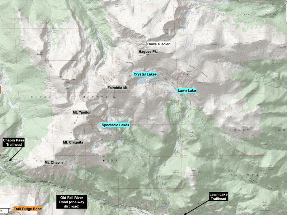
The Mummy Range Region.
- Highlights: Lots of alpine strolling, driving Old Fall River Road (Open July-September), lakes, solitude, streams, wildflowers
- Winter: Backcountry skiing Mummy Range
- Summer: Chapin-Chiquita-Ypsilon, Spectacle Lakes, Crystal Lakes, Ypsilon Mountain, Hagues Peak, Rowe Glacier, Chasm Falls
- Adventure Pick: The Desolations
Lonesome Divide
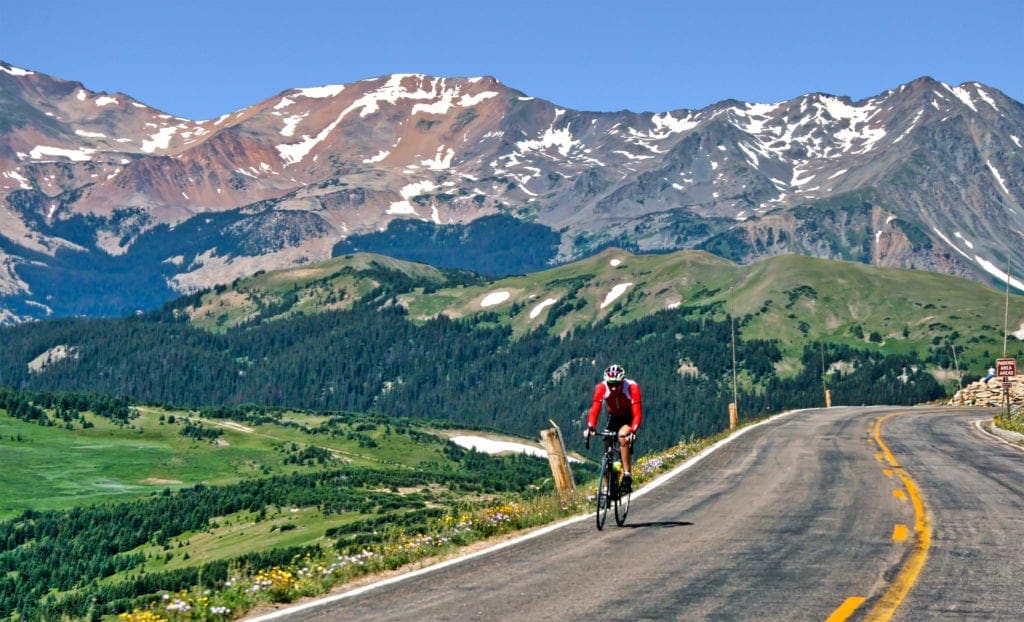
Cyclist on Trail Ridge Road in Colorado’s Rocky Mountain National Park.
High and rugged, this set of NW trending mountains along the Continental Divide is highly visible from many points along Trail Ridge. The kicker is that, despite how gorgeous they look, there aren’t many ways to access them, and each possibility will come with challenges. The best place to get a look at the area is to stop along Forest Canyon Overlook or the Rock Cut and stare south across the enormous Thompson Valley below you.
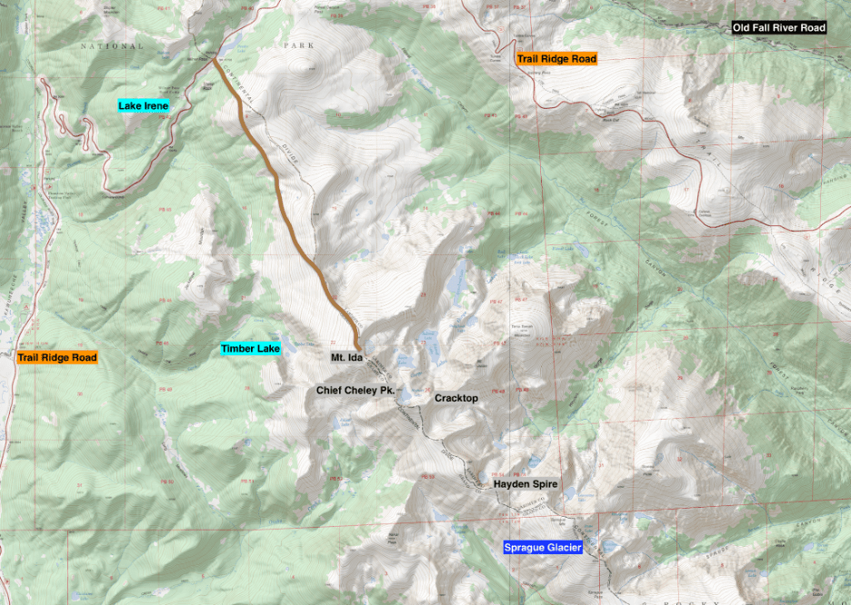
The Lonesome Divide Area.
- Highlights: Rugged alpine, remote, solitude, excellent views, forests, snow travel, primitive backcountry sites
- Winter: Tough, with Trail Ridge closed, the best way to get close to this section is to ascend Ida or Chief Cheley from Timber Lake, a very long day. For most people, this area is inaccessible when winter rolls in.
- Summer: Ida, Timber Lake, Lake Irene, Sprague Mt./Glacier via Bighorn Flats & Flattop Mt.
- Adventure Picks: Hayden Spire, GLR Scramble
The Never Summer Mountains
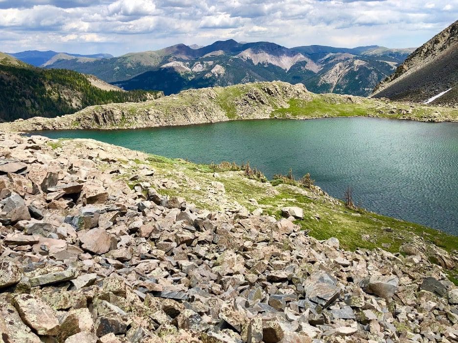
Lake of the Clouds, Never Summer Mountains.
This is a wild and remote area. There are tons of adventures tucked into these dramatic and rugged peaks. However, a lot of the more adventurous outings involve lots of off-trail navigation and a keen sense of geography. The Ditch Road (made to pull water from the Colorado River watershed into areas that hydrate Fort Collins) is a bit of an eyesore but can be connected for various loops. In the winter, the nearly flat road is snow-covered and makes for lovely cross-country skiing.
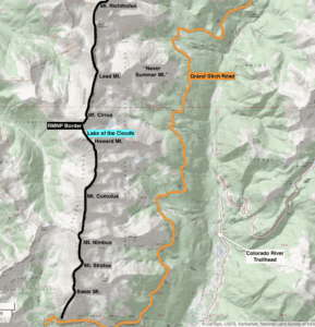
The Never Summer Mountains area.
- Highlights: Solitude, verdant green forests, Colorado River, old logging town ruins
- Winter: Backcountry skiing in the Never Summer Mountains, Cross-Country skiing up to the ditch road from Holzwarth
- Summer: Lake of the Clouds, Colorado River Trail to Lulu City, Thunder Pass, Holzwarth-Ditch Road-Red Mountain Loop
- Adventure Pick: Lead Mountain-Hart Ridge Loop
Grand Lake Region
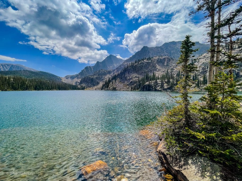
The large and impressive Lake Nanita near Grand Lake.
The trailheads in this region are located outside of the main western gate entrance on US 34 and very close to the town of Grand Lake. They are directly west of Wild Basin once you hop over the Continental Divide and southeast of the Never Summers. They provide access to miles of deep wilderness and several burn scar areas, especially near and north of Summerland Park. However, beyond these are towering mountains, sparkling lakes, and plenty of space to enjoy this quieter slice of the National Park.
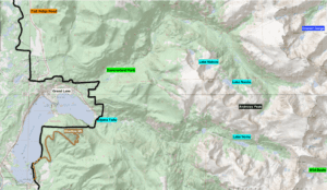
Grand Lake Region.
- Highlights: Solitude, wildlife, streams, waterfalls, beautiful lakes, alpine
- Winter: Adams Falls, Summerland Park snowshoe/cross-country ski, Tonahutu trail snowshoe/cross-country ski
- Summer: Lake Verna, Lake Nokoni/Lake Nanita, Shadow Mountain Trail, sections of the Continental Divide Scenic Trail, backcountry campsites
Guided Trips
If you’d rather have someone show you around, here are some of the best tours of the park.
- Guided Fishing Trips out of Estes Park
- Guided Horseback Riding near Estes
- Aspire Tours
- Explore Estes Park & RMNP
- 57 Hours
- REI Adventures
Conclusion
Whether you’re looking for a scenic drive through the Rocky Mountains, or a long adventure to the summit of Longs Peak, Rocky Mountain National Park is the perfect place to plan a visit. With year round adventure, a wide range of activities, and an immense amount of wildlife, no two trips to the park are likely to be the same. The next time you head to Colorado, don’t forget to add this iconic park to your itinerary.

Skyblue Overland Strongly Recommends That You Enroll With Global Rescue Prior To Embarking On Your Next Adventure.
Purchase a Global Rescue membership for your next adventure and travel with peace of mind. Single trip, annual and family options are available.
Learn More!
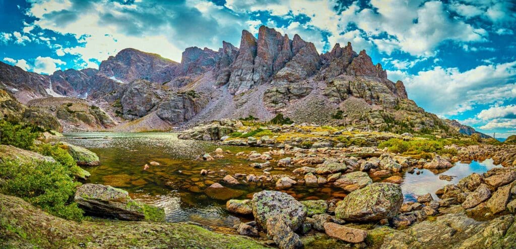
Panorama of Sky Pond and the Sharkstooth in Rocky Mountain National Park, Colorado.


