High Point:
12,400 feet

Total Ascent:
3,360 feet

Difficulty:
Hard

Distance:
12.3 miles

Waypoints:
40.272150, -105.556820

Route Type:
Out and Back
Directions from Estes Park, take CO-7 E/S St Vrain Ave. for 9 miles. Turn right onto Longs Peak Rd. and travel about a mile to the Longs Peak Trailhead parking lot. Suggest arriving early since the parking lot fills up fast on summer weekends. A late arrival will mean parking up to a 1/2 mile down the road. There are no parking signs in specific locations. A valid backcountry permit is required for overnight parking.
The trailhead has restrooms and features a ranger station (with an emergency phone) and a small campground.
Hiking to the Boulder Field via the Longs Peak Trail is a challenging 12.3 mile out and back trail with a 3,360 feet elevation gain near Allenspark, Colorado. The trail offers great views of the east and north faces of Longs Peak, alpine tundra, the Boulder Field, the Agnes Vaille shelter hut and views into Glacier Gorge. This is a rewarding hike for those who do not wish to climb to the Longs Peak summit. There are several other popular hikes on the peak that don’t require climbing including Peacock Pool, Chasm Lake, the Keyhole, or the ridge between Mount Lady Washington and the east face of Longs Peak, which is called Chasm View. The 14,259-foot (4,346 m) Longs Peak is the northernmost “fourteener” in the Rocky Mountains and the highest point in Boulder County and Rocky Mountain National Park. The mountain was named in honor of explorer Stephen Harriman Long.

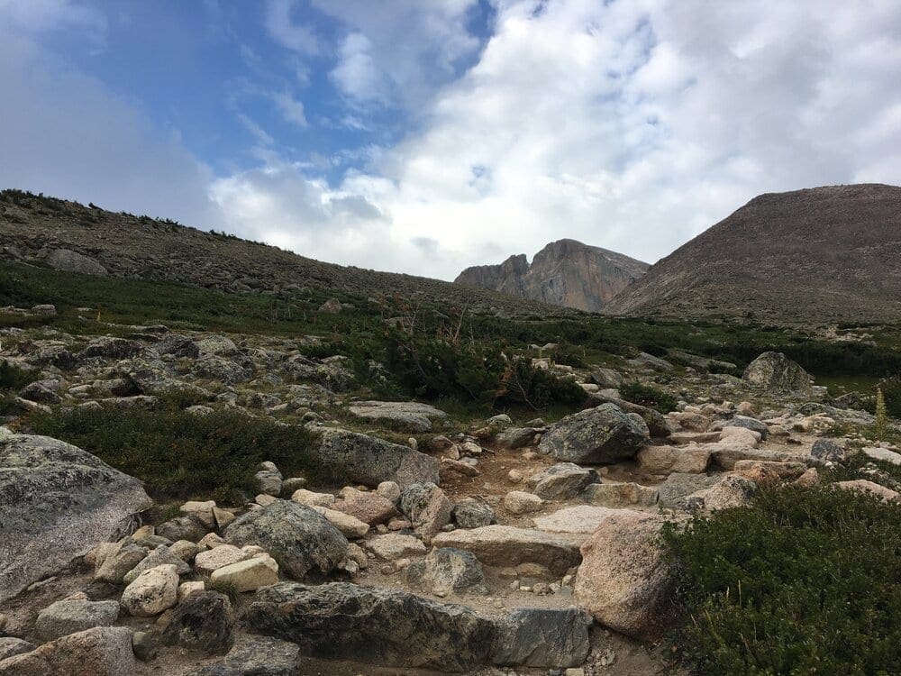
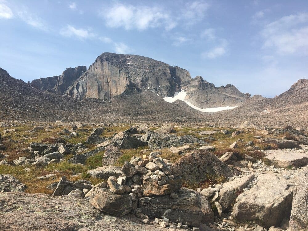
Looking southwest across the Boulder Field towards Longs Peak. The famous Keyhole is seen on the right side of the photograph at the top of the ridge.
View looking east from the Goblins Forest on the Longs Peak Trail. Getting an early 4 AM start allows adventurers to (1) see the best parts of the trail in the morning light, (2) return to the trailhead before the afternoon thunderstorms arrive, (3) find a parking spot at the trailhead somewhere west of the Mississippi River. The parking lot fills up fast!
I started my hike just before 6 AM and on my downhill phase of the hike, an afternoon thunderstorm was blowing into the region. I suggest starting earlier at 4 AM and planning on being off the mountain between noon and 2 PM. Hikers at the higher elevations in the Rockies, including Longs Peak should be especially conscious about the dangers of lightning. According to the National Outdoor Leadership School, lightning density maps show lightning strikes occurring more often at higher elevations in the Rocky Mountains where the air and climate is drier. On average, eleven people die from lightning each year in Colorado.
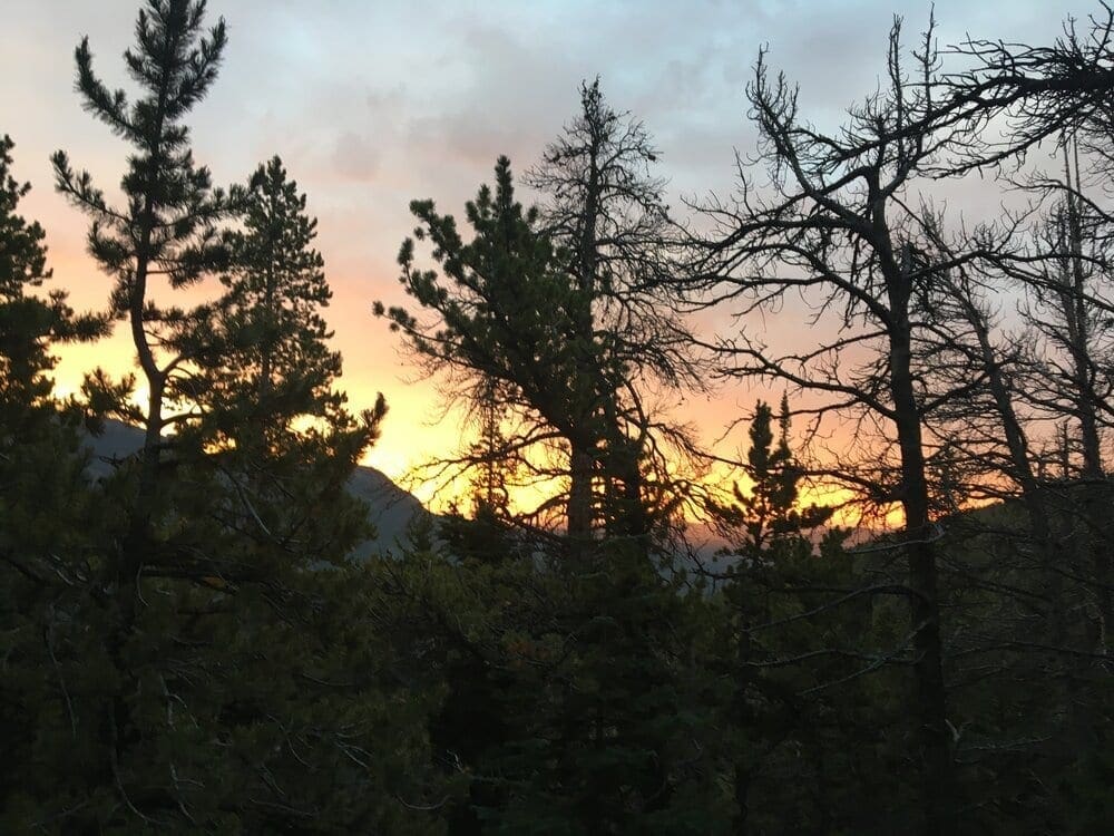
Starting hiking in the early morning darkness, the East Longs Peak Trail starts the climb though the Goblins Forest. This forest has uniform lodgepole pine trees.
Looking east over the Goblins Forest at sunrise from the Longs Peak Trail.
Hike 0.5 miles to a signed trail junction and stay left on the main trail. Continue up through the forest and pass Goblins Forest. Switchback up a hill before crossing Alpine Brook on a log bridge. Since I started at 6 AM, the sun is starting to rise over the hills by the time I get up to the noisy Alpine Brook and Larkspur Creek. Towards the top of the Goblins Forest, there are subalpine fir, limber pine, and Engelmann spruce trees.
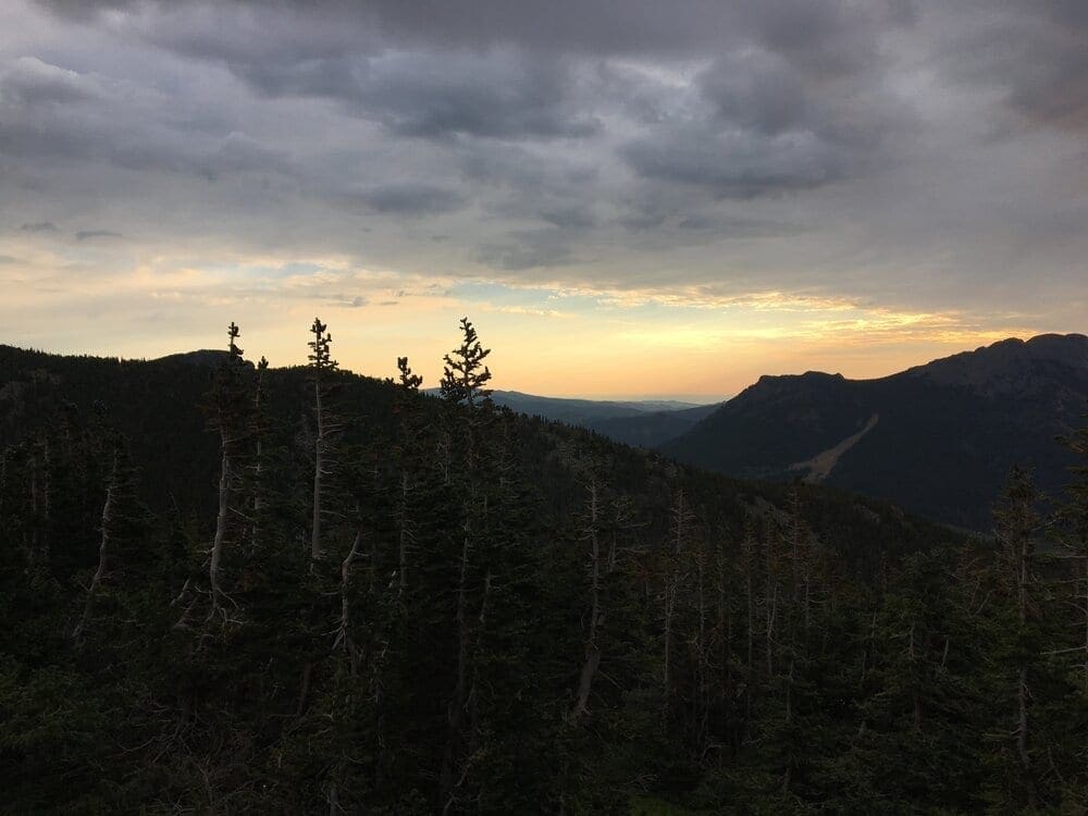
The Longs Peak trail rises above the tree line to an open treeless tundra.
As the trail reaches the tree line, the vegetation turns to crooked, bent and twisted krummholz trees. These trees are a type of stunted, deformed vegetation encountered in the subalpine tree line landscapes. Above the subalpine krummholz landscape lies numerous conifer species in an open treeless tundra.
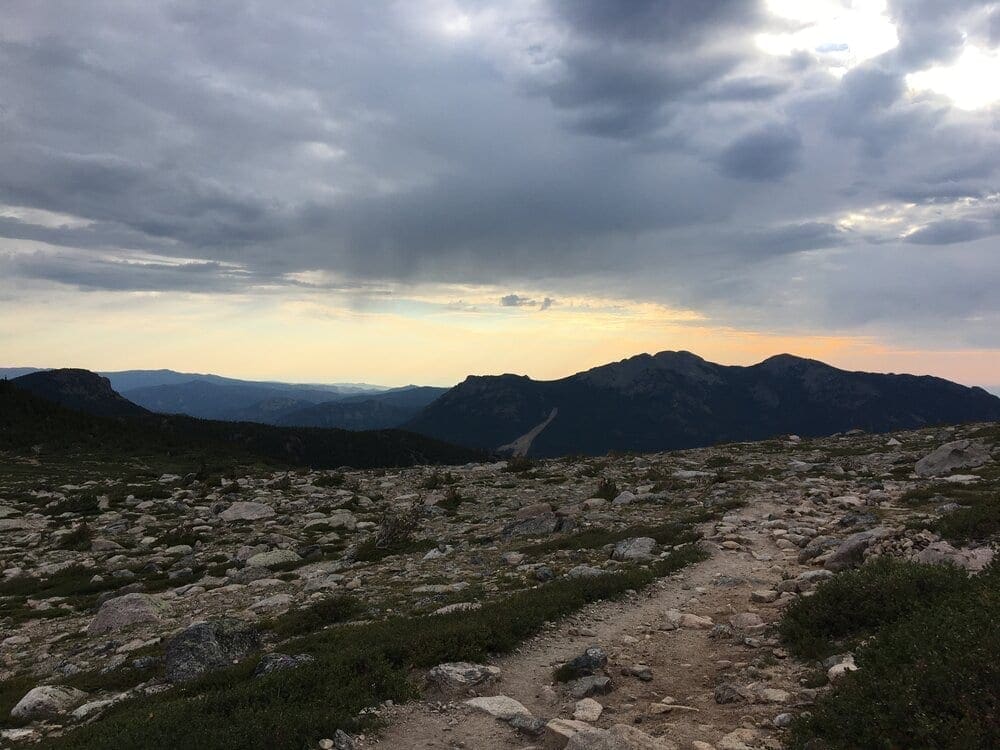
The trail continues to climb towards the Boulder Field.
Leave the heavy forest shortly after the stream crossing and continue up to tree line near 11,000′ (approximately 2.5 miles from the trailhead). Longs Peak is now in view as well as the route past Mt. Lady Washington and to Granite Pass.
Reaching Granite Pass is a significant milestone on the way up the Longs Peak Trail to the Boulder Field.
The traverse is a moderately long 4.2 miles with an elevation gain of 2,680 feet to Granite Pass (Elevation 12,080 feet). From Granite Pass, the view to the north begins to reveal Rocky Mountain National Park. Continue along the switchbacks up to the North Boulder Field. Longs Peak will now be in view as you ascend the mountain.
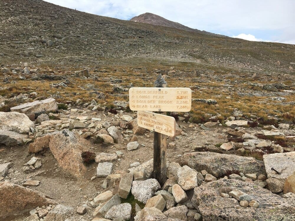
The North Longs Peak Trail heads off to the right. Stay left on the East Longs Peak Trail and switchback up and easy slope to reach the north end of the Boulder Field, near 12,400′. The north and east faces of Longs come into view, as well as Storm Peak (13,326′) ahead. Follow the trail south into the Boulder Field and past some established tent sites in the middle of the field. There is a restroom in this area.
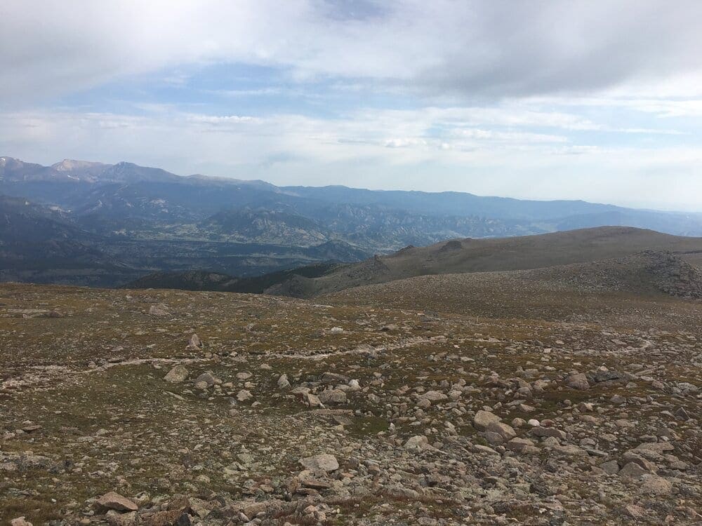
View looking north from the Boulder Field towards Glacier Gorge.
I would rate this hike as difficult with an estimated hiking time of 6 to 8 hours. See my nearby Strava.com file from my hike on August 23, 2017, which took me just under 7 hours (moving time) with my elapsed time taking about 8 hours. I did this hike with a sore meniscus on my left knee and an injured left quad muscle that kept me out of both the 2017 London and New York City marathons. I didn’t start running again until February 2018. Later that fall I finished the New York City Marathon. I was determined to hike up to the Boulder Field nonetheless, despite my knee challenged status. Most of the other hikers on the mountain that day quickly passed me. Trekking poles are a must on the downhill phase even if you don’t have a sore meniscus.
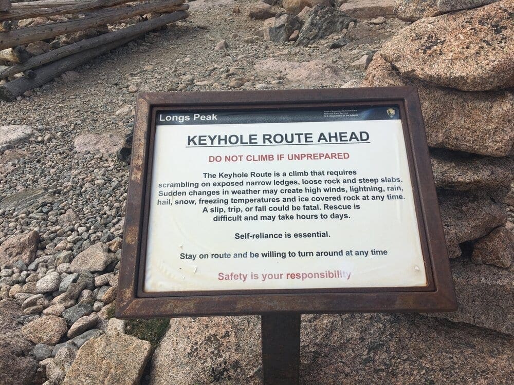
If your next goal is to reach the Keyhole, which is a notch in the rugged ridge between Longs Peak and Storm Peak. The trail finally runs out near 12,800′ on the south end of the Boulder Field but follow cairns up through the rocks to reach the Keyhole. The Keyhole Route to the top of Longs Peak is an Alpine Climbing NCCS Rating of Class III approach that is better suited for more adventurous and experienced hikers.
Camping is available at the Boulder Field and also on the lower portions of the mountain, such as Goblin’s Forest next to the stream at the bottom. It is also possible to camp to the south of the mountain at Sand Beach Lake. Camping is first-come, first-served, limited to 3 consecutive days, and is tents only.
Guidebooks, Maps and References
Rocky Mountain National Park National Geographic Trails Illustrated Map
The Colorado Mountain Club (2018). “Colorado 14ers: The Best Routes ” 180 p. Colorado Mountain Club.
Terms of Use: As with each guide published on SKYBLUEOVERLAND.com, should you choose to this route, do so at your own risk. Prior to setting out check current local weather, conditions, and land/road closures. While taking a trail, obey all public and private land use restrictions and rules, carry proper safety and navigational equipment, and of course, follow the #leavenotrace guidelines. The information found herein is simply a planning resource to be used as a point of inspiration in conjunction with your own due-diligence. In spite of the fact that this route, associated GPS track (GPX and maps), and all route guidelines were prepared under diligent research by the specified contributor and/or contributors, the accuracy of such and judgement of the author is not guaranteed. SKYBLUE OVERLAND LLC, its partners, associates, and contributors are in no way liable for personal injury, damage to personal property, or any other such situation that might happen to individuals following this route.