


|
Getting your Trinity Audio player ready...
|
The Peak-to-Peak Scenic Byway in Colorado passes through silent forests to alpine lakes with breathtaking views of the Front Range. Originally intended to connect Longs Peak and Pikes Peak, the scenic byway leads past Roosevelt National Forest, Brainard Lake Recreation Area and Rocky Mountain National Park.
Rev up your vehicles and get ready to explore the US with our Explorer’s Guides. Get ready for some amazing road trips, from the rainforests of the Olympic Peninsula to the majestic mountain peaks of Colorado’s San Juan Mountains, all the way down to the Front Range and the desert wonderland featuring vibrantly-hued cliffs in Utah’s Capitol Reef country. For more reasons why you should hit the pavement, plus handy tips and interviews, be sure to check out our adventure travel coverage here.
The gold rush may have passed, but Colorado’s Peak-to-Peak Scenic Byway still offers a wealth of wonders as it winds through silent forests to alpine lakes reflecting the soaring mountain peaks of the Continental Divide. With 1,100 peaks higher than 10,000 feet and 55 soaring above 14,000 feet, few places can claim to be closer to heaven than Colorado.
The Peak to Peak Scenic Byway is a 55-mile stretch of road located in the Colorado counties of Gilpin, Boulder, and Larimer. Originally paved in 1918, it offers stunning views of the mountain range that forms the Front Range of the Rocky Mountains. It’s notable as being the very first scenic highway established in Colorado, and its connection with Trail Ridge Road/Beaver Meadow National Scenic Byway at Estes Park further enhances its significance.
The Peak-to-Peak Scenic Byway was originally intended as part of a link between Longs Peak and Pikes Peak (thus the name Peak-to-Peak). As you travel this route, you’ll find yourself passing between spectacular sights, including Roosevelt National Forest, Brainard Lake Recreation Area and Rocky Mountain National Park.
The Peak to Peak byway, threading its way pass the lower edges of the Front Range and Rocky Mountain National Park, leads you along the Continental Divide. While traveling, visitors can view ghost towns, faded grandeur from the Victorian era and majestic Longs Peak.
The byway is passable all year round, but in autumn, its scenery has an extra sparkle with the golden hues of the changing leaves.
Good To Know: Drive safely! When driving on mountain roads, please be cautious and take necessary precautions. It’s always a good idea to have a map downloaded before you start your journey in case you enter areas with no cell service. In the winter, make sure your vehicle is equipped with snow tires or chains. And if you want to take a moment to appreciate the beautiful scenery or check your map, find a safe spot to pull over out of the way of other drivers. The wildlife tends to be very active and the afternoon rains may or may not fall. Dress in layers and pack your binoculars.
Central City
The Central City/Black Hawk Historic District (formerly just the Central City Historic District) is a National Historic Landmark that encompasses both Central City and Black Hawk, Colorado—two adjacent former gold mining camps nestled in the Front Range of the Rocky Mountains in Gilpin County, Colorado.
John H. Gregory discovered gold in hard rock on May 5, 1859, sparking the Pike’s Peak Gold Rush. Mining camps formed near the Gregory Lode, which became Central City and Black Hawk. The area around the lode was dubbed “The Richest Square Mile on Earth.” By 1861, Central City was the largest city in Colorado Territory, though Denver became the state capital.
The Central City/Black Hawk area, with a population of 3,000 at its peak in 1870, was an arc of mining camps and urban development. Placer mining claims quickly gave way to underground mining: Gilpin County produced more gold than any other American West county between 1859-1893. By the end of the 19th century, the mines were largely depleted and the area’s population drastically declined before WWI. It has yet to rebound.
The pursuit of fortune in Central City continues to this day, with the glimmering $5 slot machines drawing in those seeking luck. Though this is nowhere near the surge of success seen during the 1859 gold rush, when an estimated 2 million dollars worth of the precious metal was mined from the hills nearby.
The economic prosperity that ensued funded the construction of many outstanding Victorian buildings still standing today, such as the impressive Teller House, where Ulysses S. Grant had visited, and an opulently renovated opera house once occupied by famous celebs like Oscar Wilde and Buffalo Bill Cody. If you take a quick climb up to the west of Central City, you’ll reach the deserted village of Nevadaville, with a couple of frail dwellings still standing unabated among terrains disfigured by past mining activities.

Central City, Colorado is a former mining town turned Casino and Gambling Hub.
Good To Know: Adventurers, don’t let the chance to take a scenic drive on Oh My God Road slip away. From Idaho Springs to Central City, this route is full of breathtaking views, interesting history, and some exhilaration. Also known as Virginia Canyon Road, it’s hidden in the Colorado mountains and provides an unforgettable experience.
A nice nearby hike is the St. Mary’s Glacier Trail, a moderate, half-day hike near Idaho Springs. It is popular with families for its alpine scenery, summer flowers, lakes, and snowfield. The trail is easy to follow and leads up to a lake after half a mile. It is also great for sledding in winter. Located near Central City in Arapaho National Forest, St. Mary’s Glacier is 2.5 mi southeast of James Peak. See our trail guide for details.
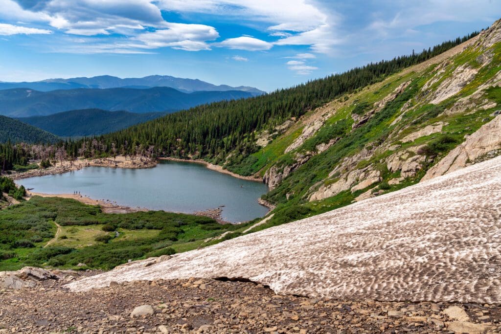
St. Mary’s Glacier, Colorado.
Roosevelt National Forest
Route 119 snakes its way up the steep canyon walls into the Roosevelt National Forest, giving travelers a taste of Mount Evans’ grandeur. The snow-capped mountain reaches an impressive 14,264 feet in the south. The highway then winds through rolling hills and ridges before leading to the entrance of Golden Gate Canyon State Park, where Denver can be seen sparkling in the majestic twilight sky.

Golden Gate Canyon State Park, Colorado
The forest envelops the mountainous terrain of the foothills located east of the Continental Divide in Larimer County and Boulder County. It sprawls over the valleys of the Cache la Poudre and Big Thompson Rivers, as well as alongside Poudre Canyon near Rocky Mountain National Park. Other elements of this woodland can be found reaching into northern Gilpin and extreme northwestern Jefferson counties.
The Roosevelt National Forest contains six wilderness areas that are part of the National Wilderness Preservation System. Four of them span into surrounding national forests, and one of those also reaches land managed by the National Park Service (as listed below). The Cache La Poudre Wilderness spans 14.47 square miles, Comanche Peak Wilderness covers 104.4, Indian Peaks Wilderness is 119.9 (largely in Arapaho NF; part in Rocky Mountain National Park), James Peak Wilderness is 26.59 (partly in Arapaho NF), Neota Wilderness takes up 15.51 (partly in Routt NF), Rawah Wilderness has an area of 119.4 (partly in Routt NF).
For a truly memorable hiking or scrambling experience in Indian Peak Wilderness, check out our helpful travel guides.
Nederland
Nestled in the rugged Front Range mountains is the small, scenic mountain town of Nederland. Although it’s home to only 1,523 people, it lies at a crossroads for many outdoor adventures. It is situated 20 miles from Boulder and half an hour from the Indian Peaks Wilderness. It is also ten minutes away from Eldora Ski Resort and on the Peak-to-Peak Scenic Byway.
Nederland, lovingly known as Ned, is a unique mountain town with an interesting atmosphere. The Arapahoe and Ute Tribes lived there before homesteaders arrived in the early 1800s. The town was named after the Dutch company who bought a nearby mine. It thrived when tungsten was found and later gained hippies looking for an easy-going lifestyle. Today, it’s known for its laid-back vibe and outdoor activities.
If you’re looking for day trips or even a few days away, Nederland offers up plenty of adventure. For more information on all that this destination has to offer, take a look at our helpful travel guide.
Nederland, Colorado.
After traversing through the charming town of Nederland, Route 72 turns and snakes along for nine miles towards Ward. This former mining camp was once quite lively until its gold reserves were depleted. If you follow this route even more westward, you’ll come upon Indian Peaks Wilderness – a paradise made up of tall pine trees and shimmering alpine lakes where snow still remains in the summer months.
The Indian Peaks have a number of nice day hikes, including Isabelle Lake, snowshoe Niwot Mt., and Mt. Irving Hale. Here’s our guides to the 5 best backpacking routes and best scrambling adventures in the Indian Peaks Wilderness.

A man runs over snow on the Isabelle Glacier Trail above Lake Isabelle in Indian Peaks Wilderness near Nederland, Colorado. Apache (left) and Shoshoni Peaks are visible in the background.
Brainard Lake Recreation Area
When you reach Brainard Lake Recreation Area down the byway, two lakes with glass-like surfaces – Red Rock and Brainard – provide stunning trout fishing. If you’re a fan of hiking, there’s a paved path to Long Lake Trailhead, where pristine views of snow-capped mountains are available. However, take caution during winter as the peacefulness of the area is sometimes disrupted by the sound of distant avalanches. If your adventures include backcountry skiing, see our guides to the ski lines in the Brainard Lake Recreation Area, and the St. Vrain Area.

Autumn at Long Lake in the Brainard Lake Recreation Area, Colorado.
Peaceful Valley Campground
Back along Route 72, the byway enters a valley with a winding creek adjacent to Peaceful Valley Campground. It isn’t rare to catch a glimpse of a bear walking close by. The campground is located right next to Middle Saint Vrain Creek in the generally flat, glacial area of Peaceful Valley. The area is home to a variety of coniferous trees and aspens that cover the region.
From the present location, the road begins to dip and winds its way into a canyon-like gap in between granite cliffs before it starts heading west on Route 7.
Wild Basin
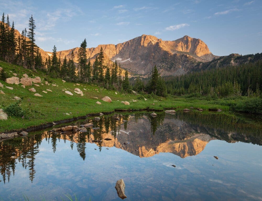
As Route 7 heads toward Allenspark, travelers enjoy a changing landscape of lush valleys, wooded ravines, and meandering creeks. Three miles past the junction is a scenic overlook with an impressive view of Mount Meeker and Wild Basin in Rocky Mountain National Park. This 265,000-acre preserve is the largest national park in Colorado, featuring 114 named peaks that reach heights above 10,000 feet and 78 peaks taller than 12,000 feet.

Views of Mount Meeker during autumn.
Wild Basin is one of the largest protected mountain basins on the eastern side of Rocky Mountain National Park and is, perhaps unsurprisingly, wild. There is only one road that gets into Wild Basin, and even then, it only goes two miles. The rest of the nearly 21,000-acre basin is networked with trails, but many ridges, alpine cirques, and lakes are only accessible via substantial cross-country travel.
Wild Basin is a place of wonder. Its natural allure comes not just from its stunning vistas, but also the numerous waterfalls and cascades that grace the area. For those seeking a long adventure into Wild Basin, combining a trip to Thunder Lake with visits to Copeland Falls, Calypso Cascade, and Ouzel Falls is a great way to explore all that this magnificent destination has to offer. To begin your journey, venture off from the main Wild Basin trailhead located off of US 7, just north of Allenspark. Ensure you’re prepared for this challenging hike by checking our hiking guide beforehand. Two additional great hiking destinations in Wild Basin are St. Vrain Mountain, and Bluebird Lake.
Thunder Lake in Rocky Mountain National Park’s Wild Basin.
Mt. Alice is one of the best scrambling adventures in Colorado. It stands tall at the Continental Divide in Wild Basin. It’s a challenging climb, requiring a 17-mile return journey with 4,810 feet of elevation gain. Another favorite is the Tanima Peak and the Cleaver. These peaks in Wild Basin are seriously fun scrambling destinations.
Longs Peak Trailhead
To the west, 4 miles north of Allenspark looms Longs Peak. Its flat-topped summit is visible for many miles, providing landmarks for those heading West during the frontier days. Being the northernmost fourteener in the Rocky Mountains of Colorado and also the highest point in Boulder County and Rocky Mountain National Park, the mountain was aptly named after explorer Stephen Harriman Long and is featured on the Colorado state quarter. To access the trailhead of Longs Peak, tour one more mile and take a side road to the west. The relentless 15-hour climb to the peak is just for experienced hikers, but it is an incredible experience, with wonderful views from the top of the Central Rockies.
Another great backcountry skiing location is Longs Peak. Here’s our Guide to Backcountry Skiing on Longs Peak.

A close-up view of the steep and rugged east face of Longs Peak, Colorado.
Still on Route 7, if you drive north for another half mile, you’ll reach the Enos Mills monument. It was erected to celebrate Rocky Mountain National Park’s founder. Mill’s tiny cabin is lined with books, photographs, climbing gear, and other mementos. Twin Sister Peaks form a rugged backdrop behind the structure.
Lily Lake
The Lily Lake Loop in Rocky Mountain National Park is a hidden gem for nature lovers. The level, accessible trail covers three-quarters of a mile and is suitable for families with young children or time constraints. To balance your exposure to sunlight, hike clockwise in the morning and counterclockwise in the evening. Or, challenge yourself by continuing along the Lily Ridge Trail, which climbs 350 feet in 0.2 miles.
Located near Estes Park, you can easily reach the trailhead by driving 6.3 miles south on Colorado Highway 7 to the Lily Lake parking area. You can park either at the lake or across the highway at the old Lily Lake Visitor Center. The Lily Lake area was purchased by Rocky Mountain National Park in 1992, and five years later, with funding from the Rocky Mountain Conservancy, the popular handicapped accessible trail was constructed using hard packed gravel.
Whether you go clockwise or counterclockwise, you’re sure to be impressed by the stunning views that surround you throughout this beautiful hike. Here’s my photo essay from my hike on June 2, 2022, which was an incredibly beautiful morning.

Longs Peak and Mount Meeker reflect off Lily Lake in morning sunshine on June 2, 2022 within Rocky Mountain National Park, Colorado. Photo by Brian Hamilton.
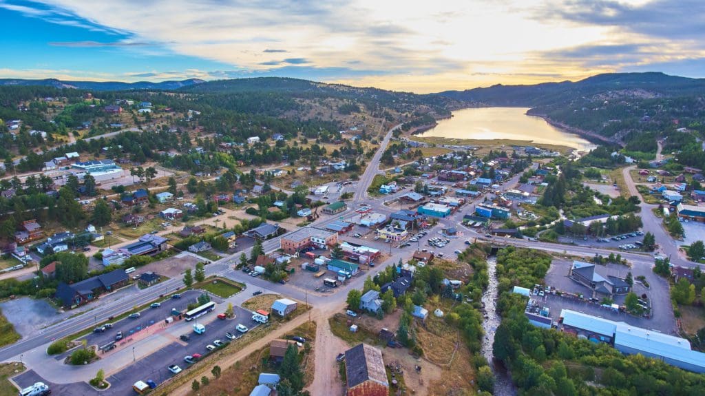
Estes Park
The road winds around Prospect Mountain before descending into Estes Park, the entrance to the Rocky Mountain National. Estes Park, Colorado tempts travelers from around the globe with its breathtaking views and activities. The riverwalk is a popular tourist attraction, as is the town’s resident elk that wander through it. Visitors can also enjoy hiking and picnicking on Lake Estes. Estes Park is the perfect base for exploration of Rocky Mountain National Park and a favorite destination for those seeking a mountain retreat.

View of the town of Estes Park, Colorado from across Lake Estes.
Towering cliffs that encircle the area bring in rock and ice climbers from around the world. Lake Estes is the perfect spot for peaceful boating, while mountain bikers and horseback riders meander through the nearby woods and fields. The Stanley Hotel overlooks it all – a historic site that first opened its doors in 1909.
Good To Know: In October 1974, Stephen King and his wife spent a night at the Stanley Hotel in Estes Park, Colorado. That night King had a scary dream about his son being chased by a firehose. When he woke up, he lit a cigarette, looked out the window – and knew he had to write. “By the time the cigarette was done, I had the bones of the book firmly set in my mind.” The result was King’s novel, The Shining and the 1980 supernatural horror film produced and directed by Stanley Kubrick.
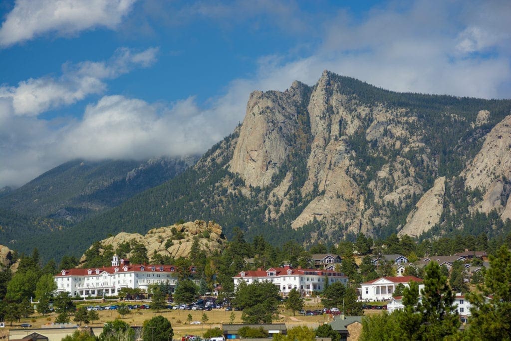
The Stanley Hotel in Estes Park, Colorado.
About 80% of National Park visitor traffic funnels through Estes Park, making it the logical place to stay if you’re visiting. The town is a 4-season playground, although it offers a much quieter experience in the winter.
If you’re searching for a day trip or a spot to stay for a few days, Estes Park offers a variety of exciting activities. To learn more about this destination’s attractions, consult our useful travel guide. If you’d rather search adventures by activity, visit our companion articles below:
- Best Waterfalls in RMNP
- Best Hiking Trails in RMNP
- Best Alpine Scrambles in RMNP
- Best Lakes in RMNP
- 5 Excellent Backpacking Routes in RMNP
Want more Skyblue Overland? Follow us on Instagram and X (formerly Twitter)

Enroll With Global Rescue Prior To Embarking On Your Next Adventure.
When a travel emergency arises, traditional travel insurance may not come to your aid, and a medical evacuation can cost up to $300,000.
The cost when you have a Global Rescue membership? $0. That’s why when the unexpected happens, you want the leader in rescue, evacuation and medical advisory behind you. You want Global Rescue.
Popular Articles:
Guide to the Best Hiking Trails in Rocky Mountain National Park, Colorado
The Dyrt: The 10 Best Campgrounds In Colorado
Top Adventure Sports Towns 2021: Boulder, Colorado
Epic Adventures with the Best Guides In Colorado
The Dyrt: The Best Camping Near North Cascades National Park
Terms of Use:
As with each guide published on SKYBLUEOVERLAND.com, should you choose to explore one of these trails, do so at your own risk. Prior to setting out check current local weather, conditions, and land/road closures. While taking a trail, obey all public and private land use restrictions and rules, carry proper safety and navigational equipment, and of course, follow the #leavenotrace guidelines. The information found herein is simply a planning resource to be used as a point of inspiration in conjunction with your own due-diligence. In spite of the fact that this route, associated GPS track (GPX and maps), and all route guidelines were prepared under diligent research by the specified contributor and/or contributors, the accuracy of such and judgement of the author is not guaranteed. SKYBLUE OVERLAND LLC, its partners, associates, and contributors are in no way liable for personal injury, damage to personal property, or any other such situation that might happen to individuals following this route.


