


|
Getting your Trinity Audio player ready...
|
Established 1999
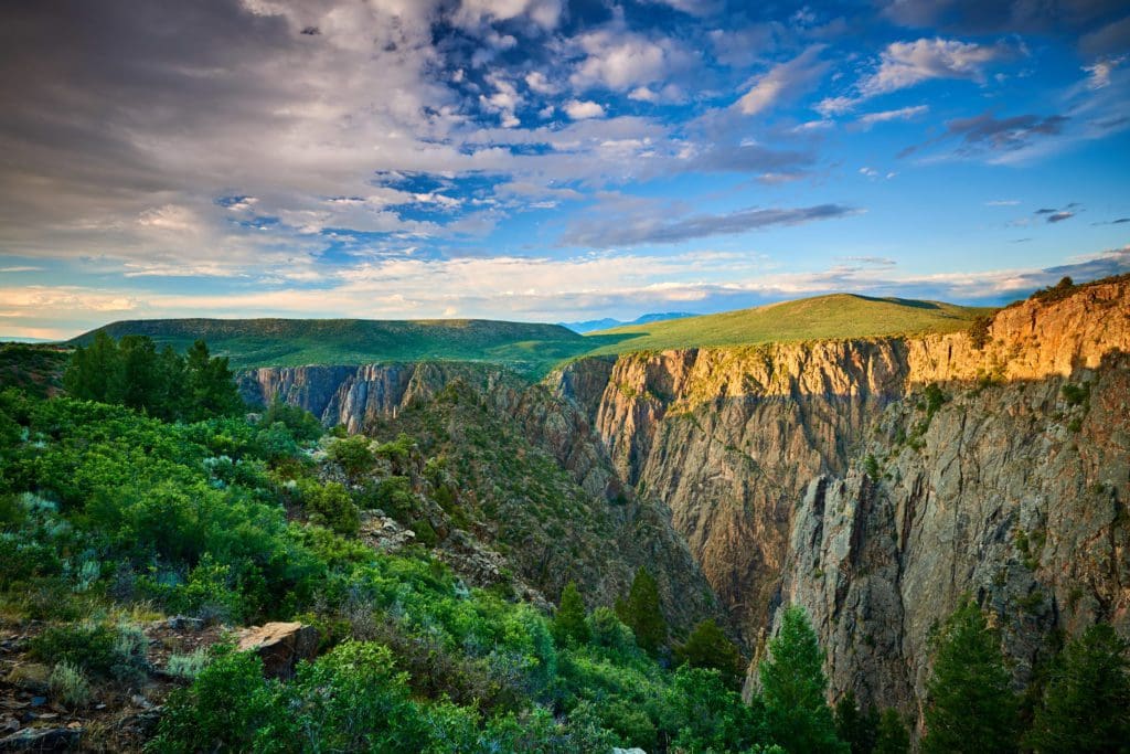
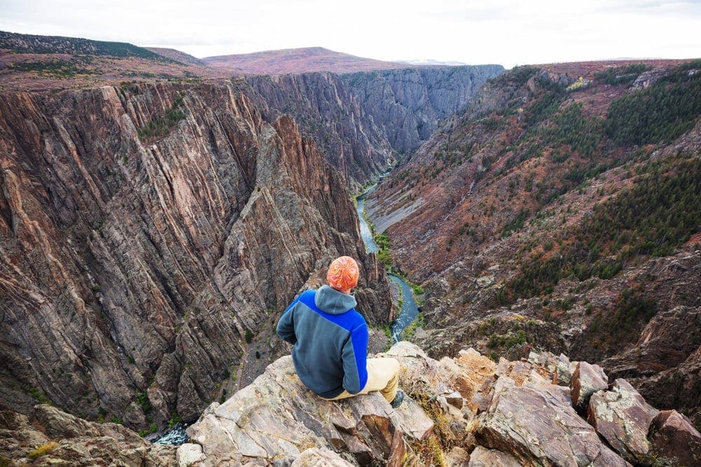
A deep, razor-sharp chasm suddenly appears, known as the Black Canyon. It’s one of North America’s narrowest and steepest gorges, beckoning adventurers to explore its rugged terrain.
Overview
Located in western Colorado, Black Canyon of the Gunnison National Park is a breathtaking natural wonder renowned for its stunning landscape and geological formations. Spanning over 30,750 acres, this national park was established in 1999 and is home to the most thrilling 14 miles of the Gunnison River gorge. The main attraction of the park is its dramatic canyon, which rivals the magnificence and steepness of the Grand Canyon with walls reaching up to 2,700 feet above the rushing waters of the Gunnison River.
Black Canyon of the Gunnison.
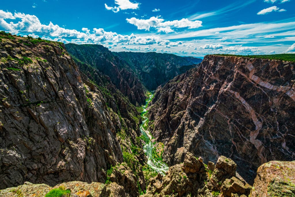
The main attraction of the park is the Black Canyon, a result of the Gunnison River and various weathering processes over a span of two million years. Its steep cliffs, ancient rock formations, and jagged spires make it one of North America’s most unique landscapes. Additionally, the park has been designated as an International Dark Sky Park, ideal for stargazing during new moon phases or when the moon rises late at night.
The park can be explored from either the South Rim or the North Rim. The South Rim is easily reachable and has a selection of viewpoints and brief hiking trails, while the North Rim provides a more peaceful and distant setting, allowing for a more secluded adventure. Various camping and RV options are provided within the park grounds, and visitors can also take advantage of recreational activities at the nearby Curecanti National Recreation Area.
For those seeking adventure, venturing below the rim to reach the Gunnison River is an unparalleled and demanding feat. The park is a sanctuary for various creatures, such as mule deer, black bears, and various bird species. Early autumn is the ideal season to visit when there are fewer visitors and the weather is more suitable for hiking.
To sum up, Black Canyon of the Gunnison National Park is an awe-inspiring natural marvel that offers a mixture of spectacular scenery, challenging trails, and peaceful isolation. Its distinctive geological formations and lack of light pollution make it an essential stop for those who enjoy immersing themselves in nature and outdoor activities.
Black Canyon of The Gunnison National Park
Table of Contents:
Article Navigation: Click on any of the listed items in the table of contents below to jump to that section of the article. Similarly, clicking on any large, white section header will jump you back to the Table of Contents.
- Overview
- Human History
- Ecology
- Geology
- Best Places To Stay
- Enjoying The Park
- Getting to the Black Canyon of the Gunnison National Park
- Conclusion
Human History
Black Canyon of the Gunnison National Park holds a diverse and fascinating human history, beginning with the Ute Indians who resided in the area since recorded time. In the 18th century, Spanish explorers arrived, followed by American expeditions in the 19th and early 20th centuries. While the Ute Indians inhabited the canyon rims surrounding the gorge, they did not live within its depths. The Spanish were the first Europeans to venture into the region, with Juan Rivera in 1765 and Fathers Dominguez and Escalante in 1776, both seeking a route to California. However, they passed by the canyon without thorough exploration. Fur trappers during the early 1800s likely knew of the canyon as they hunted for beaver pelts.
During the mid-19th century, American explorers became interested in surveying the area for various reasons. In 1853, John W. Gunnison led the Gunnison Expedition to explore the region. Subsequent expeditions, such as the Bryant Expedition in 1883, Pelton Expedition in 1900, Torrence & Fellows Expedition in 1901, and Kolb Expedition in 1916, continued to investigate the canyon in search of potential railroad routes, valuable minerals, or sources of water. However, over time, the focus shifted towards recognizing the recreational and scenic value of the canyon.
In 1933, the area was designated as a National Monument due to its one-of-a-kind and breathtaking landscape. Over six decades later, in 1999, it was granted the status of a National Park, expanding its protection and promoting its value for both tourism and conservation efforts. The park is home to a magnificent canyon that rivals the famous Grand Canyon in terms of its steepness and awe-inspiring views, with walls towering over 2,700 feet above the Gunnison River. Aptly named the Black Canyon due to its darkened walls covered in lichen, this natural wonder conveys a sense of mystery and draws visitors from all over.
The Black Canyon of the Gunnison National Park serves as a reminder of both the powerful geological processes that sculpted it over countless years, and the human legacy of adventure, enlightenment, and preservation that has safeguarded this exceptional natural marvel for future generations to appreciate.
Dragon Point Overlook of Painted Wall, Black Canyon of the Gunnison.
Ecology
The diverse ecosystems of the Black Canyon of the Gunnison National Park support a wide range of plant and animal species. The inner canyon is home to mountain animals such as bighorn sheep, as well as various birds like the Peregrine falcon, canyon wren, white-throated swifts, and violet-green swallows. Along the river, narrowleaf forests provide wood for beavers while the American Dipper bird feeds on insects in the shallow waters. Coyotes, black bears, and river otters can also be found in the park.
The park’s vegetation varies from pygmy forests to Oak flats, supporting the abundance of wildlife present. For avid bird watchers, the park offers over 125 different bird species, many of which migrate during the spring and summer months to take advantage of the different habitats.
Designated an International Dark Sky Park in 2015, the Black Canyon ensures that its night skies remain dark and unpolluted for both astronomical viewing and the nocturnal activities of its creatures. This dedication to preserving a dark sky environment safeguards the natural behaviors and habitats of these animals.
With its diverse flora and fauna and unique geological formations, the Black Canyon is a captivating destination for those who appreciate nature and outdoor activities.

Black Canyon of the Gunnison National Park.
Geology
The geology of Black Canyon of the Gunnison National Park is an intriguing exploration of deep geological time, presenting a tale of ancient metamorphic rock and ever-changing processes. This canyon’s history dates back 1.8 billion years ago with the creation of metamorphic and igneous rocks that are now 1.7 billion years old, making up the Precambrian base. These rocks, primarily consisting of gneiss, schist, and granite, were formed through a transformative process caused by the collision of volcanic island arcs from early times with what is now known as Wyoming.
Approximately 60 million years in the past, a small section of land rose up and brought these ancient rocks to higher altitudes as part of the Gunnison Uplift. Later on, there were significant volcanic eruptions on both sides of this uplift, around 30 million years ago, which resulted in the area being covered in layers of volcanic rock.
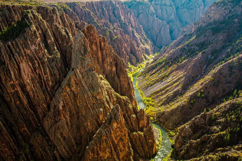
The powerful Gunnison River has carved its way through the landscape for millions of years, gradually eroding the volcanic rock and exposing the underlying metamorphic rock. The river’s steep descent, averaging 43 feet per mile, contributed to the formation of the Black Canyon’s dramatic and narrow gorge that we witness today.
The canyon’s walls, rising over 2,000 feet at certain points, are mainly made of gneiss and schist. The Painted Wall, standing at 2,247 feet as the tallest cliff in Colorado, is comprised of gneiss. The canyon’s overall dark appearance can be attributed to its steep and narrow structure, causing some areas to only receive 33 minutes of sunlight each day.
The geology of Black Canyon of the Gunnison National Park is a tale of rising land, volcanic eruptions, and the constant forces of water that have shaped its breathtaking and distinct topography.
Black Canyon of the Gunnison National Park in Colorado.
Best Places to Stay
Hotels
While there is no lodging inside the park itself, you have several options nearby:
Montrose, Colorado: This town is the closest to the South Rim of the park. Montrose offers a variety of independent hotels as well as well-known chains like Holiday Inn Express and Hampton Inn. If you prefer a more developed camping experience, Montrose has a KOA and a Jellystone campground. Ridgeway State Park, just south of Montrose, is another option with beautiful San Juan Mountains views and water activities.
Crawford, Colorado: The closest town to the North Rim, Crawford, is about 30 minutes away. Here, you’ll find independently owned motels, an RV park, and a campground. Nearby Hotchkiss and Paonia also offer similar accommodations.
Cimarron, Colorado: If you’re looking for a unique experience, consider reserving a campsite in the once bustling railroad town of Cimarron, located about 20 minutes from Black Canyon’s South Rim. Explore the visitor center and railyard while you’re there.
LeRoux Creek Inn and Vineyards (Hotchkiss, CO): For a luxurious wine vacation, stay at the LeRoux Creek Inn and Vineyards. This bed and breakfast is located on a beautiful Colorado vineyard in Hotchkiss.
Camping
There are two major campgrounds with the Black Canyon of the Gunnison National Park:
- The South Rim Campground offers some of the most impressive views within the National Park. Next to it lies the 2,250-foot Painted Wall, which happens to be the highest cliff in the entire state of Colorado.
- The North Rim Campground is much more remote. It can be accessed by the North Rim Road, with the final seven miles being unpaved. Here campers have much more solitude than at the South Rim Campground.
For those looking to camp at the bottom of the canyon, the East Portal Campground sits two miles downstream from the Crystal Dam along the Gunnison River. The nearby dam is part of the Gunnison River Diversion Tunnel. This campground is surrounded by the steep walls of the canyon, making it an ideal location for rock climbers and fishers alike.
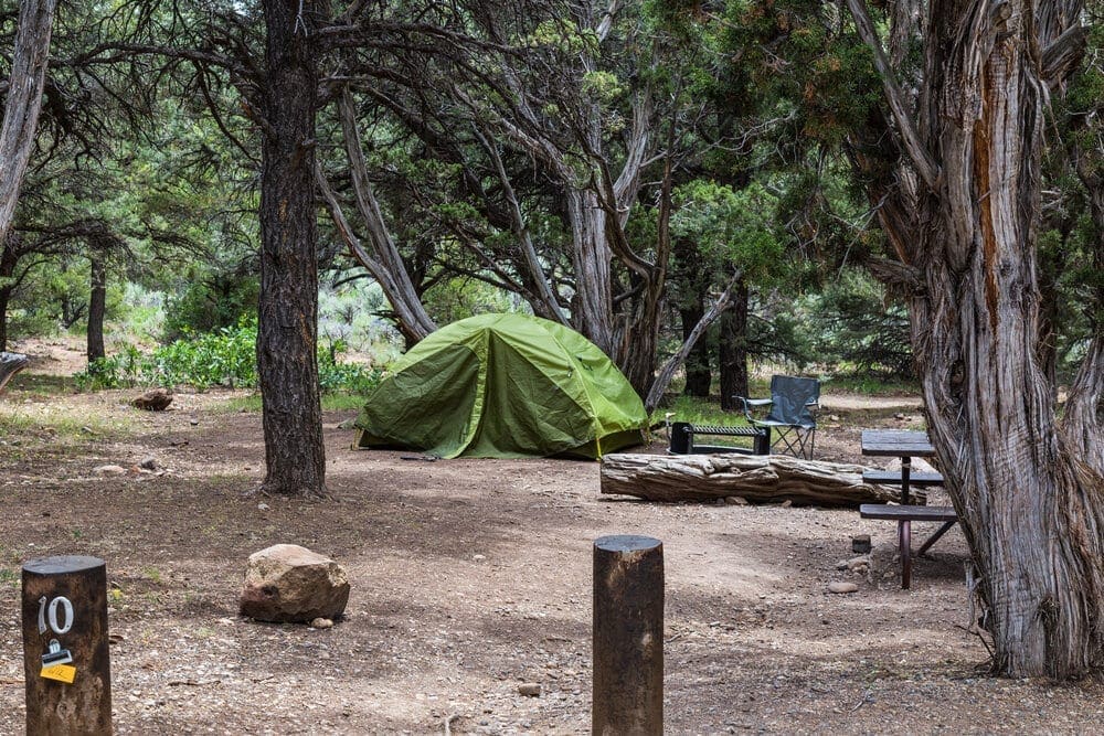
Camping in the beautiful, but remote North Rim Campground in the Black Canyon of the Gunnison National Park, Colorado
The Ten Essentials: How to Equip Yourself for the Backcountry
Enjoying the Park
Scenic Drives
Scenic drives in the Black Canyon National Park in Colorado offer a unique opportunity to explore the natural beauty and dramatic landscapes of the area. The South Rim Drive is a popular choice for visitors, with its easy access to several overlooks that provide breathtaking views of the canyon. The drive is approximately 7 miles long and features 12 overlooks, many of which are just a short walk from the parking lot. This scenic route is perfect for those looking to experience the grandeur of the Black Canyon without having to venture on a strenuous hike.
On the other hand, the North Rim Drive offers a more remote and secluded experience for visitors. This route provides a different perspective of the canyon and is often less crowded than the South Rim. Although it is a bit more challenging to access, the North Rim Drive is well worth the effort for those seeking a unique view of the Black Canyon’s dramatic cliffs and rugged terrain .
Both the South Rim and the North Rim Drives are part of the Black Canyon of the Gunnison National Park, which is known for its stunning landscapes and unique geological features. The park offers a variety of activities for visitors, including scenic drives.
Stargazing
Stargazing at Black Canyon of the Gunnison National Park is a truly enchanting experience. As one of only 115 designated International Dark-Sky Parks, Black Canyon offers unspoiled views of the night sky for star enthusiasts. Here’s what you need to know:
AstroFest: Every year, AstroFest celebrates the dark and pristine night skies of Black Canyon. This event typically occurs in September.
In 2015, the park was officially recognized as an International Dark Sky Park. With minimal light pollution, it is an ideal location for stargazing any time. But during the annual Astronomical Society’s dark-sky celebration, visitors can participate in night sky photography workshops, telescope viewings, and lectures from astronomy experts. There are also kid-friendly programs and guest speakers during the day.
Preserving Dark Skies: National parks like Black Canyon play a crucial role in preserving some of the darkest skies in the country. Light pollution not only affects astronomers but also disrupts the behavior of nocturnal animals and our own sleep patterns.
To maintain its natural dark skies, Black Canyon minimizes artificial lighting by using motion detectors and low-energy bulbs with shields.
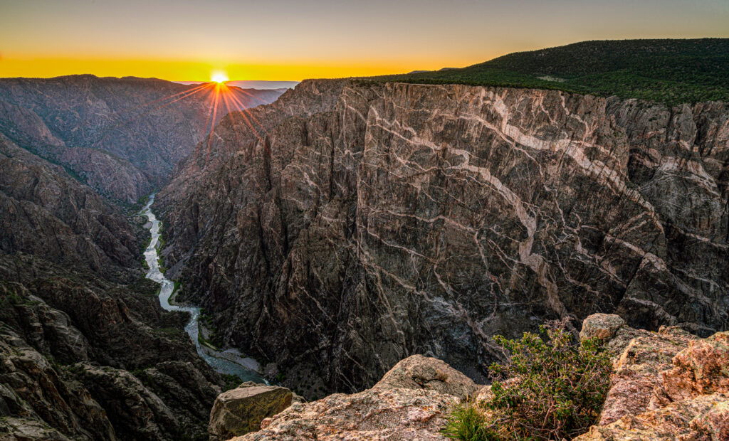
Where to Stargaze: The park is open 24/7, allowing for uninterrupted viewing of the night sky. The best spots for stargazing are overlooks away from roads such as Chasm View, Dragon Point, or Sunset View on the South Rim.
Visitors are welcome to bring their own telescopes or simply enjoy the unobstructed views for astrophotography. Just remember to bundle up and bring your curiosity as you immerse yourself in the cosmic wonders above Black Canyon!
Hiking
According to AllTrails there are several top hiking trails in the Black Canyon of the Gunnison National Park that cater to different interests and skill levels. Upgrading to AllTrails Plus enhances your outdoor adventures with features like 3D maps, offline navigation, real-time information, and safety tools. It connects you to a vast community and supports environmental initiatives.
Here are some of the best hiking trails according to their ratings and popularity:
-
Warner Point Nature Trail: With an average rating of 4.6 stars from 1,453 community reviews, Warner Point Nature Trail is one of the most popular trails in the park. This 1.5-mile moderate trail offers spectacular views of the canyon and the Gunnison River.
-
Oak Flat Loop Trail: This trail is rated as moderate and is 1.4 miles long. It’s a great choice for those looking for a more challenging hike that doesn’t descend all the way to the canyon floor.
-
Rim Rock Nature Trail: Rated as moderate, this 2-mile trail is known for its stunning views into the canyon and down to the river below.
-
Uplands Trail: An easy trail, Uplands is 2.2 miles long and is a good choice for visitors looking for a longer hike without too much elevation change.
-
North Vista Trail to Green Mountain: For a more challenging hike, the North Vista Trail to Green Mountain is a 6.8-mile trail rated as difficult. It offers panoramic views of the surrounding area from the summit of Green Mountain.
-
Gunnison Route: For adventurous hikers, the Gunnison Route is a strenuous 2.7-mile hike that provides a unique experience descending into the inner canyon.
The steep trails that lead from the rim, down to the canyon floor, are not for the faint of heart.
Rock Climbing
Rock climbing routes can be found throughout much of the Black Canyon of the Gunnison National Park. The steep walls offer routes for even the most expert of climbers.
While the Painted Wall stands at 2,250 feet, much of the climbing routes in the park can be found by the North and South Chasm Walls. Here the canyon walls stand at 1,820 feet. There are 145 named routes within the park, with 90 percent of them being trad climbs.
The canyon has a reputation of having loose rock, making for dangerous climbs and a higher fall risk. Almost all of the climbing routes within the canyon are found along the North Rim. Here popular climbs include Maiden Voyage, Scenic Cruise, Comic Relief, and Escape Artists.
The looming Painted Wall attracts some of the rock climbers in the entire world. The cliff is the third tallest in the lower 48. The Southern Arete leads off the left side of the face with 17 pitches throughout the climb.
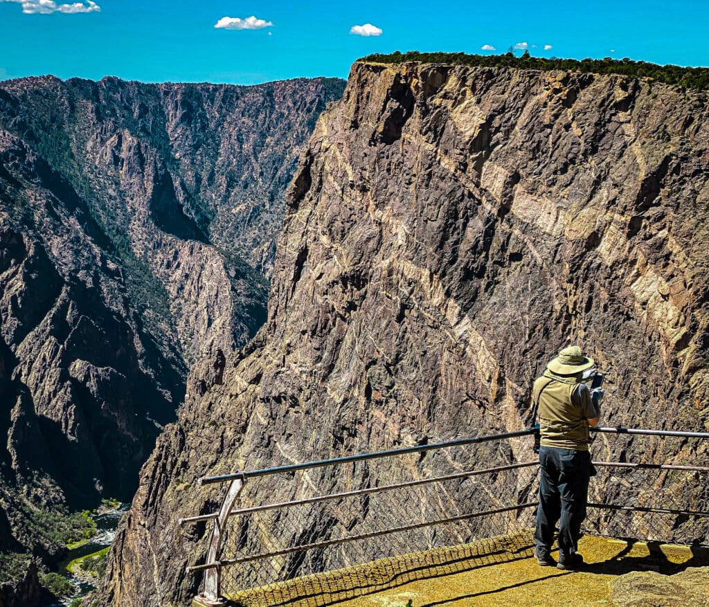
Photographing Painted Wall at Black Canyon of the Gunnison National Park.
Kayaking
While rafting is not possible within the Black Canyon of the Gunnison National Park, expert kayakers can experience the beauty of the canyon from down below. This stretch of the Gunnison River is reserved for expert whitewater kayakers only. Class V rapids, dangerous hydraulics, and cold water temperatures make self-rescue nearly impossible. And watch out for poison ivy that grows up to 5 feet tall along the river. Remember to take all necessary precautions before embarking on this thrilling journey through the stunning beauty of Black Canyon!
Fishing
The Gunnison River is rated as a Gold Medal Water and Wild Trout Water, making it perfect for going fishing in. The Gold Medal for water is given to waterways within the state of Colorado who provide healthy habitats for large trout to flourish. The best place for fishing begins a few hundred yards downstream from the Crystal Dam. The easiest access to the Gunnison River by car is via the East Portal Road, which is closed during the winter. Fishermen are limited to just a few fish so as to not disturb the natural wildlife.
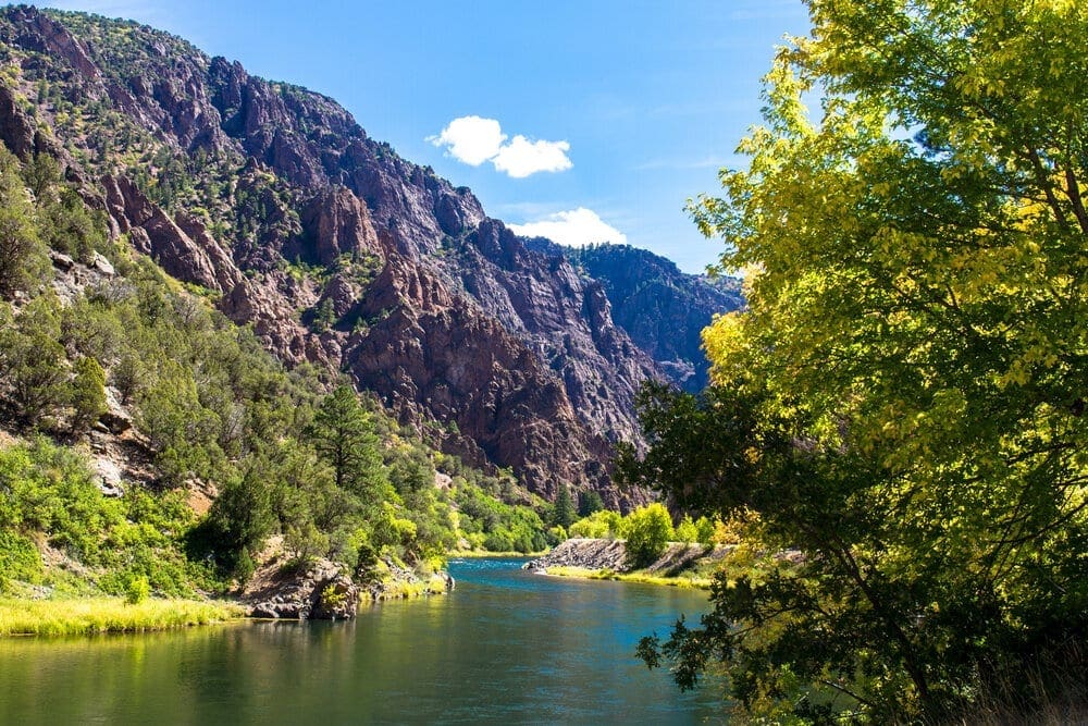
The Gunnison River is rated as a Gold Medal Water and Wild Trout Water, making it perfect for fishing adventures.
Getting to the Black Canyon of the Gunnison National Park
The Black Canyon of the Gunnison National Park is five hours from the city of Denver. Though no major cities surround the region, that helps keep the park a hidden gem of the state. To the southeast lies the city of Gunnison with a population of approximately 6,500. To the northwest of the park lies the small town of Delta, offering local shops, dining, and accommodations for those passing through the area.
To get to the Black Canyon of the Gunnison National Park, follow these directions:
- From the nearest major airport, Grand Junction, head southeast on US 50 until you reach Montrose. This town is the closest to the South Rim of the park and can be reached in just over an hour. To get to the South Rim from Montrose, take US 50 and then turn onto Colo. 3472 for a drive of about 15 miles northeast.
- Traveling from Montrose to the North Rim takes about 80 miles by car. Start off by driving on US 50W, and then make a turn towards Black Canyon Road heading west. Follow the road signs until you reach the park entrance. The last leg of the journey, a 7 mile stretch, is unpaved but will lead you directly to the North Rim.
Getting Around: Unfortunately, there is no public transportation available within the park. The best option for transportation is to use a car.
Conclusion
Tucked away in the state of Colorado lies a hidden gem: The Black Canyon of the Gunnison National Park. This breathtaking park boasts towering cliffs that overlook the river below, including the impressive Painted Wall which stands taller than both the Eiffel Tower and Empire State Building. Its steep and rugged canyon walls make it unlike any other in the country, offering thrill-seeking hikers technical descents and stunning views along the way.
Gazing into the depths of the Black Canyon can trigger a sense of disorientation as the earth seems to sway beneath you. It’s not always easy to see the bottom, hence its name which is derived from the lack of sunlight that reaches the river below. Yet, it is this same river, known as the Gunnison, that has patiently carved out this awe-inspiring canyon from surrounding volcanic rock over countless years.
Take in the abundant wildlife and explore historic remnants of a once treacherous railroad as you journey through this scenic park. Whether you’re admiring the canyon from the south rim or wandering alongside the Gunnison River, it’s sure to leave a lasting impression on even the most experienced adventurers.

Enroll With Global Rescue Prior To Embarking On Your Next Adventure.
When a travel emergency arises, traditional travel insurance may not come to your aid, and a medical evacuation can cost up to $300,000.
The cost when you have a Global Rescue membership? $0. That’s why when the unexpected happens, you want the leader in rescue, evacuation and medical advisory behind you. You want Global Rescue.
Popular Articles:
Southwestern Colorado Road Trip Report
Adventurer’s Guide to Grand Canyon National Park, Arizona
Epic Rim to Rim Grand Canyon Backpacking Tours
Top Adventure Sports Towns: Crested Butte, Colorado
Planning The Ultimate Colorado Road Trip
Terms of Use: As with each guide published on SKYBLUEOVERLAND.com, should you choose to this route, do so at your own risk. Prior to setting out check current local weather, conditions, and land/road closures. While taking a trail, obey all public and private land use restrictions and rules, carry proper safety and navigational equipment, and of course, follow the #leavenotrace guidelines. The information found herein is simply a planning resource to be used as a point of inspiration in conjunction with your own due-diligence. In spite of the fact that this route, associated GPS track (GPX and maps), and all route guidelines were prepared under diligent research by the specified contributor and/or contributors, the accuracy of such and judgement of the author is not guaranteed. SKYBLUE OVERLAND LLC, its partners, associates, and contributors are in no way liable for personal injury, damage to personal property, or any other such situation that might happen to individuals following this route.


