


|
Getting your Trinity Audio player ready...
|
The Olympic Peninsula Loop is a 330-mile route through Washington’s Olympic Peninsula, showcasing rainforests, mountains, coastlines, and National Park attractions like Hoh Rainforest and Ruby Beach. Charming towns and scenic drives make it a perfect journey of discovery.
Rev up your vehicles and get ready to explore the US with our Explorer’s Guides. Get ready for some amazing road trips, from the rainforests of the Olympic Peninsula to the majestic mountain peaks of Colorado’s San Juan Mountains, all the way down to the Front Range and the desert wonderland featuring vibrantly-hued cliffs in Utah’s Capitol Reef country. For more reasons why you should hit the pavement, plus handy tips and interviews, be sure to check out our adventure travel coverage here.
Overview
Spanning approximately 330 miles, the Olympic Peninsula Loop offers a picturesque route that encircles the Olympic Peninsula in Washington State. This journey promises a diverse range of sights and experiences, from lush rainforests to towering mountain peaks, rocky coastlines to abundant waterways, and vibrant tide pools. The loop includes access to the renowned Olympic National Park, where travelers can explore iconic attractions such as the Hoh Rainforest, Lake Crescent, and the Strait of Juan de Fuca.
The Loop is easily accessible via Highway 101, which runs along the coast and through the heart of the Olympic National Park. Along the way, visitors can stop at charming towns like Port Angeles and Forks, take a hike through the verdant Hoh Rainforest, or soak in breathtaking views of the Pacific Ocean. The loop also features popular beaches including Ruby Beach and Rialto Beach, known for their striking rock formations and driftwood-covered shores.
In addition to natural wonders, the Olympic Peninsula Loop provides opportunities to learn about local history and culture. Visitors can explore Native American heritage at the Makah Cultural and Research Center in Neah Bay or visit the Victorian seaport town of Port Townsend, known for its well-preserved 19th-century architecture.
The Olympic Peninsula Loop is a journey of discovery, offering something for everyone, whether you’re a nature enthusiast, a history buff, or simply looking for a scenic drive through one of the most beautiful regions in the USA.
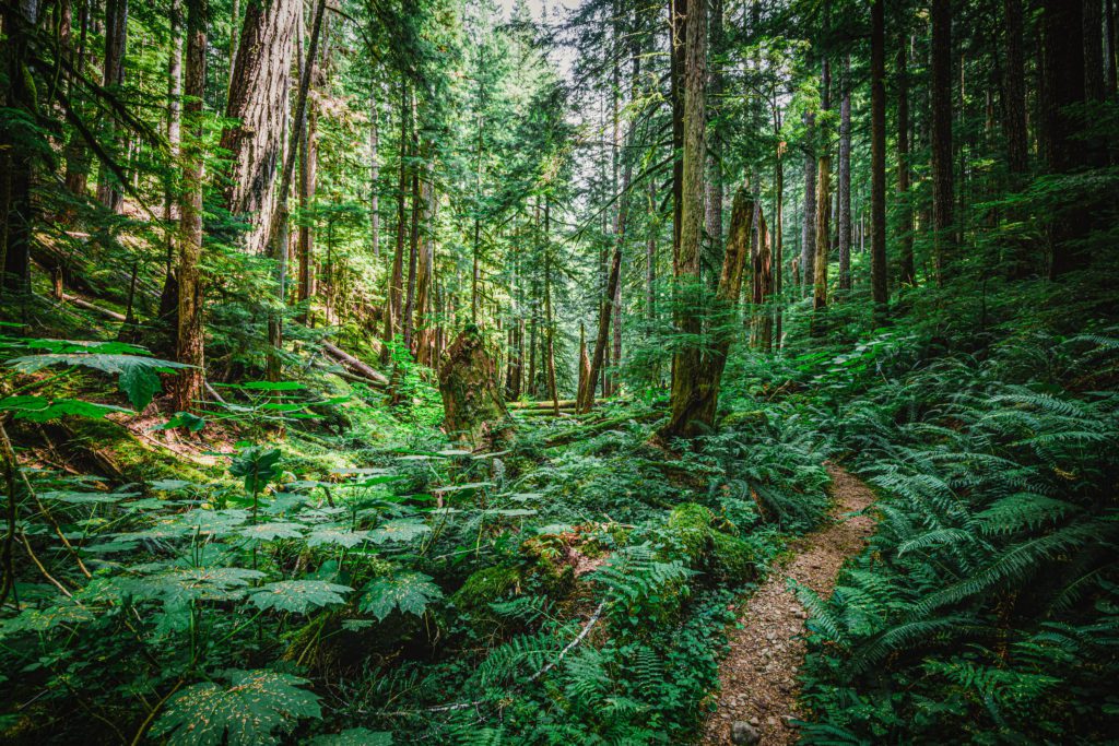
Trail through the temparate Hoh Rainforest in Olympic National Park, WA
You can take in breathtaking sights every few minutes as you traverse flats and subalpine forests, lakes and rivers, majestic Olympic Mountains capped with glaciers, temperate rainforests, and the wild Pacific Ocean. Inhabiting nearly one million acres are the Olympic National Park that offer plenty of recreational opportunities for all skill levels. There is so much to discover that we strongly suggest taking two or more days to truly appreciate the region’s beauty.
The Olympic Peninsula loop road is a popular destination no matter the season, but it’s especially ideal to visit from April through October. An informed traveler should bring along rain apparel for any outdoor activities such as hiking and camping. Additionally, if planning on beach walking, you should refer to a tide chart.
Certain spots around the shoreline can only be traversed during low tide. Be sure to always have a tide chart close at hand—you should be able to grab one from coastal ranger stations and visitor centers. Never guess, always check!
If there is a strong wind or storm, it could change the high tide significantly—and create dangerous conditions. Thus, it’s important to stay aware of your environment and never take the power of the Pacific Ocean lightly.
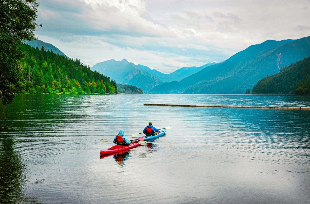
Kayaking on Lake Crescent in Olympic National Park, Washington.
Rent an RV with Outdoorsy: Take an RV on your next road trip to get closer to nature. For more details, check out www.outdoorsy.com
Table of Contents:
Article Navigation: Click on any of the listed items in the table of contents below to jump to that section of the article. Similarly, clicking on any large, white section header will jump you back to the Table of Contents.
- Overview
- Potlatch State Park
- Dosewallips State Park
- Mount Walker Viewpoint
- Port Townsend
- Sequim
- Dungeness National Wildlife Refuge
- Port Angeles
- Hurricane Ridge Road
- Elwha River Valley
- Lake Crescent
- Sol Duc Hot Springs
- La Push
- Bogachiel State Park
- Hoh Rain Forest
- Ruby Beach
- Kalaloch
- Quinault Valley Rainforest
Potlatch State Park
Potlatch State Park is situated in a stunning waterfront location, near the Pacific Ocean, Strait of Juan de Fuca, and Puget Sound. Driving along Route 101 for about thirty miles from Potlatch to Brinnon offers superb views of the wooded banks of Hood Canal, an extension of Puget Sound. The park is 57 acres and derived its name from special celebrations held by local native tribes. It’s ideal for activities such as clamming or oyster picking and an excellent spot for hosting a picnic.
The hidden gem of Potlach State Park can be found nestled among the trees 40 miles from Olympia, along the breathtaking Hood Canal. Recently, the creek in this park was restored to help improve the salmon population. Elk herds are often seen, and pileated woodpeckers can be heard tapping out their song on the trees.
Before you make your way to Potlach, don’t forget to bring your buckets, rubber boots, crab traps, boats and necessary permits. This park is the perfect place for shellfish harvesting! You can find oysters, crabs and clams here that will suit any taste.
If the ocean is exceptionally high or if there’s a windy day, visitors can choose to go wind surfing, fly kites, or simply sit back and take in the spectacle. Potlatch is renowned for its tranquil waters and often attracts divers and kayakers. The park also offers seasonal Junior Ranger and kids’ educational programs, making it an ideal destination for families. For those who enjoy hiking, some of the region’s best trails are located within a half hour drive across four rivers.

Hood Canal with Olympic Mountains in the distance.
Dosewallips State Park
Sitting on both sides of Route 101, this park covers over a thousand acres and is home to the fresh water of the Dosewallips River and the salt water of Hood Canal. The gentle waves of the canal make it an ideal environment for clams and Quilcene oysters, which are named after the town that houses one of the most expansive oyster hatcheries in existence.
Dosewallips State Park, a mere 60 miles away from Olympia, is situated on the eastern edge of the Olympic Peninsula. The area is made up of multiple terrains including forests, mountain ranges, rivers and beaches – all surrounded by sea and sound. It makes an ideal place to take a day trip or to have a weekend getaway. You can stay here while touring the historical forts and little towns north of here; it could also be your first stop if you’re planning on having a grand adventure around the peninsula.

Dosewallips River
The park’s lush forest, blanketed in moss, and a glacial river that slopes down to the shores of Hood Canal make it an amazing experience for people who love clams, fishing, boating, birdwatching, and exploring beaches. There are campsites near the riverside, cabins, and five-person tents set up on platforms for visitors.
Visitors may observe the local elk herds as they leisurely stroll through camp, although it is important to stay at least 100 feet away and never give food to them. Bald eagles can be spotted near the beach, and great blue herons flock around the river.
As the sun begins to set, you may be grilling some freshly caught seafood for dinner before settling down in your cabin or tent. All around you will be enjoying the lush greens of nature and you will drift off to sleep with the soothing sound of the Dosewallips River nearby.
Dosewallips State Park offers year-round camping experiences, complete with five miles of coastline on Hood Canal and the Dosewallips River. All camping grounds are surrounded by lush greenery in a tranquil, rural environment.

Storm rolling in over Dosewallips State Park, Washington.
Mount Walker Viewpoint
Drive a few miles north of Brinnon, take a left onto a bumpy gravel road that winds its way up Mount Walker. Once you reach the peak, you will be treated to the mesmerizing view of over five million acres of land—a space nearly equivalent in size to New Hampshire.
Mt. Walker is blanketed by 100-year-old Douglas-fir trees that sprung up in a section disturbed by a wildfire. Colorful Pacific rhododendrons also line the road and surfaces of both North and South observation points. These vibrant purplish-pink flowers bloom from May to June. It’s the lone peak overlooking Puget Sound that has an access road to its summit. There are two areas with short trails to the lookout point, each with educational signs detailing the area. The southern viewing area additionally has a compressed gravel path leading out to the lookout spot, and it features a bench too.
If you stand at North Viewpoint, looking just west of Buck Mountain, Mt. Jupiter can be seen through the notch in the horizon. This is the closest high peak to Hood Canal and a part of the massive Olympic Mountain range. Mt. Constance is the third highest mountain here with its breathtaking rock faces, while Big Quilcene Canyon is fed by numerous small streams.
The fourth highest peak in Washington state is towering Mt. Baker, whose glacial structure only comes second to Mt. Rainier’s size. On an unusually clear day, this snow-capped mountain can be spotted from far away in the northeast.
Lastly, Buckhorn Mountain holds three peaks near Marmot Pass, and just next to it Quilcene Bay provides a safe haven for boats and houses several oyster farms that are known around the world for their signature Quilcene oysters.
The South Viewpoint offers a breathtaking view of Hood Canal, the large waterway created by the Vashon Glacier during the Ice Age roughly 10,000 years ago. Serving as a bridge between the Olympic and Kitsap Peninsulas is the impressive Hood Canal Floating Bridge.
In the distance sits Mount Rainier, the highest peak in Washington state at 14,410 feet above sea level. It’s an ice-covered volcano that towers over 9,000 feet above the surrounding foothills. Its glaciers are the largest in the contiguous United States.
On a clear day, visitors can make out major metropolitan areas like Everett 33 miles away, Seattle 28 miles away, and Tacoma 39 miles away. With perfect visibility, even Seattle Space Needle can be seen. Many people travel to Mount Walker each year to enjoy its panoramic views of Mount Rainier, Puget Sound, and Seattle from its summit.

Postcard view of the Puget Sound from the top of Mount Walker in Washington.
Port Townsend
Once you make your way down Route 101, take a detour on the nearby Route 20 which will lead you to the town of Port Townsend. Located at the entranceway to Puget Sound, this charming coastal settlement was once a bustling seaport with boats from all corners of the world crowding its port. Today, its main attraction is its collection of 19th century buildings that have been preserved to perfection; some of them have been turned into bed-and-breakfast inns and showcase San Francisco’s iconic gabled Victorian style. Moreover, between May and September visitors can find tours of the area’s most picturesque homes.

Pier at Port Townsend, Washington
Captain George Vancouver christened the bay “Port Townshend” in 1792, naming it after a friend of his, the Marquis of Townshend. It was soon realized that the area provided a safe harbor; however, the southerly winds and poor anchoring grounds can make it difficult for small boats to dock near the town’s waterfront.
Port Townsend hosts several annual events like the Wooden Boat Festival, Kinetic Skulpture Race, Rhododendron Festival, Film Festival and blues and jazz festival. Boating and maritime life are important in this port town with regattas, races and recreational events such as the Race to Alaska and Seventy48. The marine trades industry is an economic anchor for the community, with highly skilled tradespeople. Classic wooden boats find refuge in this port.
Good To Know: For the last 40 years, Port Townsend in Washington has established itself as an essential port for wooden boatbuilding and upkeep on the West Coast. This harbor town is where the wisdom of wooden boat construction is passed down from generation to generation, impacting the lives of those who embark upon the open sea. Read our story, Combining Quality and Passion to Make the Open Sea Possible.
Port Townsend hosts an annual international film festival every September. The Rose Theatre downtown shows American and foreign films, the Uptown Theater shows family films, a drive-in theater is open in summer, and Key City Public Theatre puts on award-winning plays and Shakespeare in the Park.
In August 2019, historic Fort Worden started the “THING” music festival, an eclectic and intimate three-day festival of music and arts. In 2023, Fleet Foxes, led by Port Townsend’s Robin Pecknold, were the headliners.
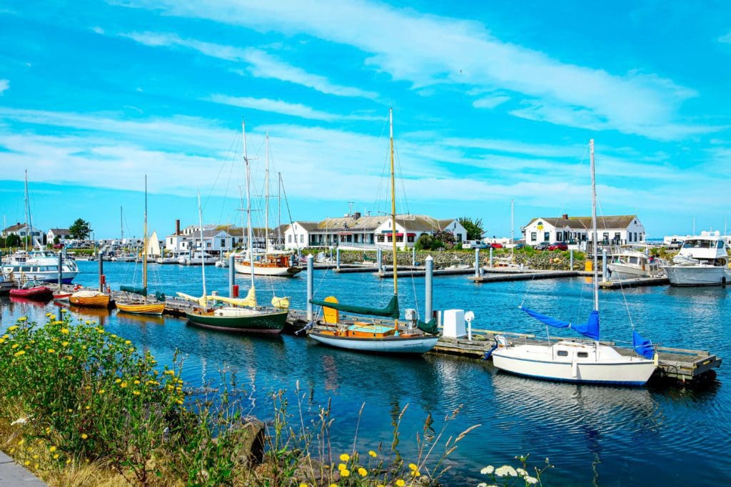
Port Townsend, Washington’s downtown marina with boats and historical buildings.
Sequim
Sequim is nestled between the Olympic Mountains and the Dungeness River. It only receives an average of 16 inches (410 mm) of precipitation each year, making it comparable to Los Angeles in terms of rainfall. Therefore, locals have nicknamed the area ‘Sunny Sequim’. But, despite its arid climate, the city is close to some of the wettest temperate rainforests in all of the continental United States. Sequim is said as one sound, with the e omitted: “skwim”. The name came from the Klallam language.
Sequim, and the nearby region, are widely known for commercial lavender farming, which has earned it the title of “Lavender Capital of North America“. This is a status only France could challenge. Furthermore, Dungeness crab can be found in abundance here too.

Lavender fields near Sequim, Washington.
Traveling east along Highway 101 one will find Sequim Bay, a 4-mile (6.5 km) long body of water connected to the Strait of Juan de Fuca. At the western edge lies the Sequim Bay State Park – an ideal spot for birdwatching.

Scenic view of Dungeness Spit, the longest sand spit in the USA, on a sunny day.
Dungeness National Wildlife Refuge
The Dungeness National Wildlife Refuge encompasses 772.52 acres (312.63 ha) of sand spits, Harbor, and Bay. Dungeness Spit is 6.8 miles (10.9 km) long and has a lighthouse, the New Dungeness Light, built in 1857. Access to it is through a County Park with trails, picnic areas, and a campground. President Woodrow Wilson designated it a National Wildlife Refuge on January 20, 1915. It is part of the Washington Maritime Complex.
The refuge provides habitat for 250 species of birds and 41 land mammals, plus Waterfowl, Wader, Shellfish, Chinook, Coho, pink salmon and chum salmon. Many waterfowl migrate through the area seasonally. Black brant can be seen from late October to early May, peaks in April. Shorebirds and water waders feed along the shoreline, and Harbor seals rest on Dungeness Spit. The tideflats have crabs, clams, and other shellfish.
The Dungeness crab is a species of crab, typically growing to 20 cm across the carapace. It is a popular seafood with a common name derived from Dungeness Spit. Mature crabs can reach 10 inches in width; they are a delicacy in the Pacific Northwest and are celebrated yearly at the Dungeness Crab and Seafood Festival in Port Angeles, Washington.
Dungeness National Wildlife Refuge has been identified as an Important Bird Area by the National Audubon Society. It is internationally significant as it serves as a migration and breeding area for birds from Alaska to South America. Additionally, it is a key spring staging area for black brant and other waterfowl.

Dungeness Spit Lighthouse on largest sandspit in US which is wildlife refuge near Sequim, Washington.
How to Kill, Cook and Eat Dungeness Crab: Fresh Dungeness crab is the best West Coast seafood, and this recipe will be worth the effort. Enjoy fresh crab meat seasoned with butter while your dinner guests get hands-on for a memorable experience. Serve with crusty grilled bread, chilled white wine, and friends who are ready to work for their food. Read more at the Filson Journal.
Port Angeles
In 1791, Spanish explorer Francisco de Eliza christened the shelter of Port Angeles with the moniker Puerto de Nuestra Señora de los Ángeles (Port of Our Lady of the Angels). As time went on, this name was simplified and partially anglicized to Port Angeles Harbor what it is known as today. Port Angeles is not only the biggest city in the Olympic Peninsula, but also serves as the entrance to Olympic National Park which spreads across the peninsula like a majestic centerpiece.

Port Angeles, Washington.
Port Angeles offers a unique combination of seaside and mountain attractions, making it an ideal spot for enjoying all sorts of water activities. You can go paddling, scuba diving, standup paddleboarding, surfing, or kayaking in the Strait of Juan de Fuca, take to the Elwha River, or even explore one of the nearby mountain lakes like Lake Crescent.
Gaze in wonder as the majestic whales swim by. The trail begins along California’s coast, then continues on through Oregon and Washington, ending at the Strait of Juan de Fuca in British Columbia. Depending on the season and where you are, you could catch a glimpse of orcas, minke, gray and humpback whales from shore. For an even better view, join a whale watching cruise departing from Port Angeles Harbor for some up-close whale watching.
Nestled at the foot of one of the most diverse and beautiful National Parks in America, Port Angeles is a true gem. The Olympic National Park has almost 1 million acres for year-round exploring, plus dozens of more outdoor adventures outside the park. There’s no end to the activities you can enjoy, from hiking through lush forests to biking down quiet country roads and combing beaches for hidden treasures.

Port Angeles Harbor at sunrise.
Hurricane Ridge Road
Visitors to Olympic National Park can take a 18-mile journey from Port Angeles to Hurricane Ridge, which gets its name for the 100 mile-per-hour winds that can occur in winter storms. On this drive, you’ll pass through a forest of Douglas firs where deer, marmots, and black bears are often seen. The road is dotted with turnouts presenting stunning views of Strait of Juan de Fuca, Dungeness Spit, Vancouver Island, and sometimes even the northern Cascades across Puget Sound. Upon reaching the ridge top, visitors can marvel at the San Juan Islands and Canadian coast in the north; to the south are rollercoaster-like peaks of the Olympics, topped by Mount Olympus at 7,965 feet.
Standing at a towering height of 5,242 feet (1,598 m), Hurricane Ridge is an all-season destination that sees visitors throughout the year for activities such as hiking, skiing, and snowboarding. It is one of the two most visited places in the national park, just after the Hoh Rainforest.
During summer, hikers flock to the area. In contrast, small crowds gather during winter months at the family-oriented Hurricane Ridge Ski and Snowboard Area where lift-serviced downhill skiing and snowboarding are offered. West of the Hurricane Ridge visitor center, there are several picnic areas and trailheads all along the road. The paved Hurricane Hill trail is about 1.6 miles (2.6 km) long, one-way, with an elevation gain of roughly 700 feet (200 m). It’s typical to find snow on these trails even in July. Many other dirt trails, varying in length and level of difficulty, branch off from the Hurricane Hill trail. Although inaccessible in winter, picnic areas provide access to restrooms, water, and paved tables for summer convenience.
For those who’d like to take in the scenery at Hurricane Ridge, they can either hike along the Big Meadow Nature Trail or drive up Obstruction Point Road, an 8-mile stretch of unpaved road. During wintertime when snow is piled up as high as 20 feet and often sticks around until June, Hurricane Ridge becomes a hub for skiing, sledding, and snowshoeing.
In May 2023, the visitor center was damaged due to a raging fire. This meant that visitors had to stay away from the area for a month while repairs were being done; only when they were finished was it re-opened, but with limited access.

Views of the Olympic Mountains from Hurricane Ridge in Olympic National Park, Washington.
Side Trip: For an unforgettable adventure, take a side trip to Neah Bay. Just a few miles away from Port Angeles take Route 112 along the coast. This 62-mile trek meanders past the Elwah River and through lush wooded hills which gradually give way to breathtaking coastal scenery as you make your way towards Neah Bay.
The Makah Museum there hosts thousands of ancient artifacts, and a nearby path brings visitors to Cape Flattery (1.5 miles round trip with an elevation gain of 200-feet) , the northwesternmost point in the lower 48 states. From this lookout spot, you can get up close views of Tatoosh Island and the entrance to the Strait of Juan de Fuca.

Cape Flattery at Neah Bay, Washington.
Exploring Shi Shi Beach and Point of the Arches will provide breathtaking views of the unspoiled Olympic Coast. The round-trip hike covers 8-miles and can be done in a day, but it also makes for an ideal backpacking experience. Photographers may want to stay for one or two nights to capture a sensational sunset over the vast expanse of rock pillars in the sea.

Shi Shi Beach in Neah Bay, Washington.
Elwha River Valley
The Elwha River Valley is located in the central northern area of Olympic National Park. Located 11 miles west of Port Angeles, the Elwha Valley is reached by the Olympic Hot Springs Road, off of Highway 101. The highway leads to Elwha, where a paved road follows the course of the pristine Elwha River—one of the best streams for fly-fishing. The tall trees cast shadows that block most views of the river, but there are plenty of turnouts so you can capture some picturesque photos. You’ll pass by two campgrounds, a lake and an overlook before reaching a 2-mile trail to Olympic Hot Springs.
The Olympic Hot Springs Road and Whiskey Bend Road offer sightseeing opportunities through the valley’s lowland and montane forests, as well as access to a number of hiking trails. Popular dayhikes in the area include the Boulder Creek trail and the Humes Ranch Loop.
Fishing in the Elwha is catch and release only. Make sure to check out fishing regulations for Olympic National Park before you come.
The Elwha region is currently off-limits to cars that go beyond the parking lot at Madison Falls, the border of the park. The only vehicles allowed here are bicycles and pedestrians. The Olympic Hot Springs Road is accessible in this area for cyclists and walkers, but there aren’t any services available on the other side of the gate at the car park. There is a path around the flooding if you need to get through it but remember that pets must be kept on leashes at all times on the road itself as well as other trails. Be sure to check all conditions before beginning your journey.
Be sure to check road status, weather conditions and trail conditions before your visit.

Elwha River.
Lake Crescent
Lake Crescent can be found deep within Olympic National Park, just 17 miles away from Port Angeles if you take Route 101. It is the second deepest lake in Washington’s waters, reaching depths of up to 624 feet or 190 meters. This size beats out even Lake Chelan, which holds the record as the deepest body of water in the state.
Lake Crescent is renowned for its extraordinary blue hue and crystal-clear depths, attributed to the lake’s low nitrogen levels that hinder algae growth. The area around the lake is a popular recreation spot, with several trails, such as the Spruce Railroad trail, Pyramid Mountain trail, and Barnes Creek trail to Marymere Falls. The Spruce Railroad Trail follows the former railway track along the lake’s shores. A stroll down this path on the north side of Lake Crescent reveals an entrance to an old railroad tunnel as well as ‘Devils Punch Bowl’, a much-loved swimming and diving destination.
Good To Know: Be aware when swimming—watch out for the little ones, and get life jackets for them if they are too young. Even though the waters seem to be deep, cliff jumpers should be wary of possible risks like rock formations that could injure them or any debris in the water.

Devil’s Punch Bowl at Lake Crescent, Washington.
The lake is surrounded by a number of spots to have a picnic. Fairholme, Bovee’s Meadow, La Poel (in the warmer months), and North Shore all have tables available for use.
During the summer and fall, many people come to Lake Crescent for fun on the water. You can find boat launches set up at the east and west sides of the lake, with rowboats available for rent at Lake Crescent Lodge. People come here to kayak, sail, or just relax on the beaches and coastline – it’s a perfect destination for outdoorsy folks looking for a nice day trip.
At the west end of Lake Crescent, adventurers can pitch a tent at the Fairholme campground which has 87 campsites – one of them is wheelchair accessible. For those who want something with more amenities, there is Lake Crescent Lodge or Log Cabin Resort nearby. The former can be found near Barnes Point along Highway 101, and the latter is situated north of the highway on East Beach Road. Usually, these attractions are open from late spring up to early fall. Both locations offer overnight accommodation in rooms and cottages.
Millennia ago, glaciers formed deep valleys that would eventually form Lake Crescent. Before then, the valley flowed into Indian Creek and the Elwha River with anadromous fish like steelhead and coastal cutthroat trout coming up from lower waters.
Approximately 8000 years ago, a great landslide from the Olympic Mountains blocked Indian Creek, causing it to form into two distinct lakes: Lake Crescent and Lake Sutherland. According to Klallum tribe legend, Mount Storm King became angry with warring tribes and threw a boulder that split Lake Sutherland in two. From the top of Pyramid Mountain, this event is still visible today. The water eventually took an alternate route out of the valley and fell into the Lyre River, down the falls at Lyre River, and finally spilling out to the Strait of Juan de Fuca.
The evidence shows that a powerful earthquake, possible measuring up to 9.0 on the Richter scale, caused the massive landslide in the valley and its surrounding river. Although it’s difficult to spot now since the region has returned to normal, anyone climbing Pyramid Peak will get a good view of the large-scale effects of this eight-thousand-year-old incident.

Crescent Lake in Olympic National Park, Washington.
Sol Duc Hot Springs
The peaceful, therapeutic waters of Sol Duc Hot Springs could be the cure for a long day of exploring and venturing. The Sol Duc Hot Springs Resort in Olympic National Park, Washington state, offers hot springs-heated pools and tubs, as well as a swimming pool. Nestled in a valley carved by the Sol Duc River, this is the place to relax and rejuvenate.
Sol Duc Hot Springs Resort lies 12 miles deep into the secluded heart of Olympic National Park. Spend your time here relaxing in pure mineral-rich outdoor hot springs, taking in the lush views of the forested peaks and listening to the soothing sound of water trickling over pebbles and stones in Sol Duc River. Enjoy a delicious lunch at our Deli Cafe, or take a short hike through the grand primeval old-growth rainforest with the rhythm of Sol Duc Falls for accompaniment.
For centuries, the local Native American population had recognized the therapeutic benefits of these springs. It wasn’t until the 1880s that settlers became aware of them. In 1912, a luxurious resort opened up, and it was said to be “the most noted pleasure and health resort on the Pacific Coast” until it burned down in 1916. The resort was reconstructed in the 1920s, but did not match its original grandeur. It operated into the 1970s despite an issue with its thermal spring, but overcame this problem and reopened again in the 1980s where it continues to serve thousands of visitors every year. Additionally, Olympic Hot Springs lies nearby and remains undeveloped.
Sol Duc Valley in Olympic National Park provides stunning sights, from gigantic trees to frothing rapids, glacial lakes to snow-covered mountains and an abundance of wildlife. There are numerous trails in the valley as well as one of its most popular attractions: Sol Duc Falls (1.6 miles, roundtrip with an elevation gain of 200-feet). The area is teeming with lush rainforest foliage, old-growth trees and a roaring cascade.

Scenic view of Sol Duc Falls.
La Push
As you keep going west on Route 101, the drive leads you away from Olympic National Park and towards the town of Forks. A mile away from the village, take a 15-mile side trip to La Push, an ancient Native American settlement which is now home to the Quileute Reservation. This little town’s charcoal-grey beaches are known for the ever-changing driftwood they carry as well as spectacular views of whales in the distance and sea stacks near shore.
The popular Quileute Days take place every July in La Push. The tribal celebration of cultural heritage and modern lifestyle includes a fireworks display, a traditional salmon bake, dancing and songs, a softball tournament, and other field sports, a slow-pitch tournament, a horseshoe tournament, arts and craft display, and food concessions.
The Pacific Northwest National Scenic Trail passes through La Push on the way to its western terminus at Cape Alava. The Pacific Northwest Trail (PNT) is a 1,200-mile (1,900 km) hiking trail running from the Continental Divide in Montana to the Pacific Ocean on Washington’s Olympic Coast. Along the way, the PNT crosses three national parks, seven national forests, and two other national scenic trails. It travels against the grain of several mountain ranges, including the Continental Divide, Whitefish Divide, Purcells, Selkirks, Kettles, Cascades, and Olympics.

Beautiful sea stack at sunset from Second Beach near La Push, Washington.
Bogachiel State Park
Bogachiel State Park lies on the lush river basin of the Bogachiel River and boasts over 127 acres of dense forestry. It is an ideal spot for exploring western Olympic Peninsula, and camping reservations are open between May 15 – September 15.
The Bogachiel River is a perfect illustration of a lowland rainforest habitat, complete with a winding and rugged path that continues to the top of the valley. Unlucky enough not to have been fed by glaciers like the Hoh, Queets, and Quinault rivers, it doesn’t boast their eye-catching turquoise tones or enormous amounts of water. What it does provide is plenty of exploration opportunities and peace and quiet.

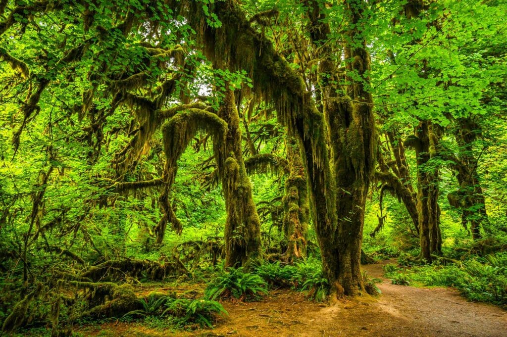
Bogachiel Rainforest.
Hoh Rain Forest
To get to the Hoh Rain Forest, you can drive two hours from Port Angeles or just under an hour from Forks. It’s located along the Upper Hoh Road, which can be accessed by taking Highway 101.
Deep in the heart of the Pacific Northwest, a stretch of rainforest once spanned from southeastern Alaska to the central coast of California. One of the finest examples of this temperate rainforest still thrives within America’s borders – The Hoh Rain Forest. It is a popular destination among nature enthusiasts and visitors alike for its unparalleled beauty and ecological importance.
The Hoh River originates in Mount Olympus, flowing swiftly towards the Pacific Coast and earning its name from a Native American language. It is believed that the word “Hoh” may be derived from the Quileute word for “fast moving water,” or “snow water.” Others believe it comes from the Quinault word meaning “boundary,” since the river creates a striking divide across the terrain. There is even an old legend that claims the name refers to a man with quarreling wives. In any case, the true source of the title remains uncertain.
No matter what you call it, the draw of the rainforest is undeniable – luring visitors back year after year. During the cooler months, rainfall in the Hoh Rain Forest is greater than average at 140 inches (3.55 meters). This abundance of precipitation causes a magnificent panoply of evergreen and deciduous trees to thrive, along with thick carpets of mosses and ferns that add to its mesmerizing charm.
Hall of Mosses trail at the Hoh rainforest in Olympic National Park, Washington.
The Hoh Rain Forest provides camping all year round, with 72 campsites tucked away among the ancient trees and situated close to the river. During peak times it is necessary to reserve a spot in advance by using recreation.gov; reservations can be made up to six months prior.
The trailhead is found at the end of the Upper Hoh Road near the Hoh Rainforest Visitor Center, which has lots of useful information for visitors. The staff there can offer advice and provide details about the area’s unique features. During summertime, the center is open daily but from January to early March, it usually only operates on Fridays, Saturdays and Sundays (opening times may change depending on the season).The trails are split into two loops that start and finish close to the Visitor Center and a single path that begins and ends in the same spot near the site.
Trail through the temparate Hoh rainforest in Olympic National Park, Washington.
The Hall of Mosses Trail (.8 miles/ 1.2 km) is a classic loop that takes you through an area of ancient trees covered in club moss. The Spruce Nature Trail (1.2 miles/ 1.9 km) passes though both mature and new growth forests, following the Taft Creek to the Hoh River. The Hoh River Trail is the main pathway in the region. It’s an out-and-back trail that one can follow for as far as they want – 18.5 miles/ 30 km until you reach Glacier Meadows and the Blue Glacier at Mt. Olympus. There is also a detour off the Hoh River Trail past the ranger station to Bogachiel Peak between the Hoh and Sol Duc Valleys. For those only looking for a day hike, there are several popular stopping points along the path.

View of Mount Olympus and the Blue Glacier from Hurricane Ridge in Olympic National Park.
Ruby Beach
After leaving the misty rainforest, our drive takes us to Ruby Beach, wedged between the Kalaloch Strip. Not far from the highway lie several pathways leading to this 11-mile stretch of Olympic National Park’s seashore untouched by time. One difference one can spot from here is the garnet crystals that give the sand its pinkish hue – hence the name Ruby Beach. Offshore sea stacks are a reminder of days long gone, when these massive blocks were still part of the main land.

Ruby Beach, Olympic National Park.
Kalaloch
A short drive south of Ruby Beach leads to Kalaloch, the largest coastal beach campground on the Olympic Peninsula. From its lofty bluff, you can observe jaw-dropping views of the ocean, especially during wild weather days. Clamming, surf fishing and beach walking is a pleasure here but at low tide, the amusement goes up a notch as people explore the pools filled with sea urchins, hermit crabs, anemones and other aquatic life forms.
If you’re looking for birds, Kalaloch is the spot! You can find western gulls, bald eagles, and other coastal wildlife nesting and feeding along the beach. Beach 4 is a great location to get up close and personal with sea stars and anemones that come out during low tide. When you go on your hike, be sure to check out the current tide chart at the Information Station. Some areas may become impassable during high tides, so it’s best to be aware of alternate trails if needed.
If you are looking for a place to camp on the southern coast of Olympic National Park, your best bets are Kalaloch and South Beach. Of the 175 campsites at Kalaloch, four are wheelchair accessible and sites fill up fast; book early to avoid disappointment. South Beach is slightly smaller with 50 campsites, and is open from Memorial Day to late September. Kalaloch Lodge, located right on the beach, has rooms and cabins available upon reservation. You can see the view from the Kalaloch Lodge by viewing their webcam!

Rock-strewn Kalaloch Beach on Washington’s Pacific Coast.
Quinault Valley Rainforest
The Quinault Valley is a passage to pristine meadows, glistening lakes, and snow-covered summits. For those looking for a briefer experience, the valley offers travelers a loop drive with picturesque views plus trails through lush rainforest in both Olympic National Park and Olympic National Forest.
The Quinault Valley has two campgrounds – North Fork Campground with nine sites, pit toilet, picnic tables, and fire rings, and Graves Creek Campground which offers 30 sites, restrooms (only in summer), picnic tables, and fire rings. No potable water is available there year-round, only an accessible vault toilet. North Shore Road is too skinny for trailers or large RVs. There are also three Olympic National Forest campgrounds on the south side of the lake.
The Quinault Rainforest Ranger Station is the perfect spot to begin your hiking journey. Start with the 1.3-mile loop that leads to the Kestner homestead, or take a stroll through the groves of bigleaf maples nearby. If you’re feeling adventurous, go on a longer hike through the Olympic Wilderness towards the North Fork Quinault River to Low Divide, or head eastward along the East Fork Quinault River and discover the historic Enchanted Chalet.
If you’re lucky, you may spot the largest land mammal in Olympic National Park: Roosevelt elk. These animals tend to be darker and bigger than Rocky Mountain elk, with males weighing up to one thousand pounds. The bulls grow new antlers annually, shedding their old ones in the spring before regrowing them throughout the summer.
Throughout the year, you’ll find herds of cows, calves and young bulls foraging in abandoned homesteads. In the fall mating season, bulls compete to form bands of up to thirty cows with which to mate. Their loud, shrill cries can be heard echoing through the valley as they vie for power over one another.
Elk munch on shrubs and plants that populate the understory of the woods, creating an open park-like atmosphere for visitors. The valleys of the west side are teeming with these animals, their populations more robust and less migratory than those to be found on the other side of the range.
The elk of this area have made it through countless changes. In the late 1800s, they were nearly extinct due to overhunting. In an effort to save them, President Theodore Roosevelt formed the Mount Olympus National Monument in 1909. By 1938, when the park was officially opened, the elk numbers had been restored.
At this time, approximately 3-4,000 elk are protected within Olympic National Park. Elsewhere, they face risks from hunting and a changing environment. Inside the park, though, they can roam freely across the landscape as they have for ages, modifying it with their presence and being influenced by its features. With ongoing caretaking and attention, these majestic animals should be able to continue their lives in the forest and give joy to onlookers for many years to come.

The Quinault river flowing through Enchanted Valley in Olympic National Park.
Lake Quinault is a beautiful lake surrounded by temperate rainforest. The water comes from glacial runoff in the Olympic Mountains and the Quinault River, giving it that clear, fresh look.
It’s located in the Quinault Valley, which was carved by a glacier long ago. This area of Washington state is owned by the Quinault Nation, a group of Native Americans who were originally called kʷínayɬ. They’ve lived on this reservation since 1856, when they signed the Quinault Treaty.

Sunset over Lake Quinault, Washington.
Lake Quinault Lodge is a beautiful, historical hotel built in 1926 with all the classic features. You can relax and take in the scenery or go explore the outdoors through activities like hiking, biking, boating, fishing, and more. The main lobby of Lake Quinault has a roaring fireplace and plenty of comfortable seating. Inside you’ll find the Roosevelt Dining Room that serves up breakfast, lunch, and dinner with stunning views over Lake Quinault.

Exterior view of the historic Lake Quinault Lodge in Olympic National Park. MelissaMN – stock.adobe.com
Want more Skyblue Overland? Follow us on Instagram and Twitter
Popular Articles:
Adventurer’s Guide To Olympic National Park, Washington.
Adventurer’s Guide to Glacier National Park, Montana


